background image

Welcome

9

Copyright 2010 by AirNav Systems

1.4

The RadarBox Community

The RadarBox Community

The popularity of RadarBox has resulted in a highly committed group of users, who through their
enthusiasm, have helped with the development of this application.  By sharing their data and making
suggestions for additional features, the users have contributed to the success of Radarbox.  AirNav
Systems remains totally committed to working closely with the RadarBox community and looks
forward to continued development.

AirNav Systems would particularly like to thank the radarbox.gofreeserve.com website and its
contributors and also contributors to the AirNav Systems Forum, in allowing airline logos and airport
layouts created by them to be added to the official release version of this application.

2

Getting Started

2.1

Installation

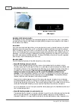
AirNav RadarBox Installation

DO NOT CONNECT THE HARDWARE USB CABLE TO YOUR COMPUTER BEFORE INSTALLING
THE SOFTWARE
If you need any help during the installation process visit AirNav Systems support page

The AirNav RadarBox system is made up of two parts.

·

The hardware - consisting of the receiver, antenna and USB cable

·

The software - delivered on CD or downloaded as an update from the AirNav website

You must install the software first. Once the software installation is complete, you can
then install the hardware. RadarBox uses a device driver supplied on the CD. It is vital
that this driver is installed and that Windows is not allowed to install a random driver
form the Internet, otherwise RadarBox will not function. Failure of the RadarBox software
to connect to the hardware receiver is almost always due to failure to install the correct
driver. Follow the below steps to correctly install RadarBox and start tracking flights in
real-time on your computer. For help in troubleshooting the driver installation, see the 
Troubleshooting section.  Please note that if you change the RadarBox USB connecting
cable to a different USB port, then you will have to install the driver again for that port. 
This is a limitation of the way that MS Windows manages USB ports and not an issue with
Radarbox.

1. Run the setup.exe file located on the root folder of the provided CD. Follow registration
instructions paying special attention to the User Agreement.

Summary of Contents for RadarBox

Page 1: ...Copyright 2010 by AirNav Systems AirNav RadarBox Manual...

Page 2: ...24 2 Aircraft Details Autopopulate 25 3 Aircraft Route Autopopulate 26 4 Creating Alerts 28 5 MyLog Database 31 6 Creating Reports 33 7 Viewing Aircraft Photos 34 8 Using Filters 35 9 SmartView 37 10...

Page 3: ...pecial Country Flags 82 3 Custom Outline Maps 83 4 Data Output on Port 7879 85 5 Timeout Settings Part VI Troubleshooting 86 86 1 Hardware Connection 88 2 Network Connection 89 3 RadarBox Without an I...

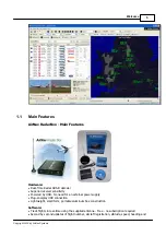
Page 4: ...utions AirNav Systems AirNav RadarBox is equipped to be used in locations all over the world 3D multi window maps with worldwide coverage contain more than 200 thousand geographic points included Airp...

Page 5: ...ceiver sensitivity Powered by USB No need for an external power supply Plug and play USB connection Lightweight small form portable aluminum box construction Software Track flights in real time using...

Page 6: ...ction is fully interactive with all menus operational Comprehensive callsign and route database Autopopulate of aircraft route and phot database Internet connection required Maps High definition world...

Page 7: ...tainous terrain where there is no radar coverage or where radar coverage is limited The outback of Australia is one such area where ADS B will provide surveillance where previously none existed ADS B...

Page 8: ...ing ADS B position information However it is still possible to see the identity and type of the aircraft and their altitude The last 2 aircraft are transmitting full position information shown by the...

Page 9: ...AirNav RadarBox system is made up of two parts The hardware consisting of the receiver antenna and USB cable The software delivered on CD or downloaded as an update from the AirNav website You must in...

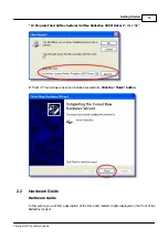
Page 10: ...oftware installation is complete connect the USB cable from the hardware to your computer Windows will detect that AirNav RadarBox is connected 3 When the below windows appears under Can Windows conne...

Page 11: ...t 2010 by AirNav Systems 4 Under What do you want the wizard to do select Install from a list or specific location Advanced Click Next 5 Select Search for the best driver in these locations and then s...

Page 12: ...that is inside the folder where AirNav RadarBox software has been installed The standard location of the AirNav drivers is C Program Files AirNav Systems AirNav RadarBox 2009 Drivers Click Next 5 Driv...

Page 13: ...s AirNav RadarBox 2009 Drivers Click OK 7 That s it The hardware has been installed successfully Click the Finish button 2 2 Hardware Guide Hardware Guide In this section you will find a description o...

Page 14: ...puter but there is no valid data connection between the software and the hardware receiver This could indicate the USB driver is not installed correctly or that there is a problem with your USB cable...

Page 15: ...coverage the following points should be noted The supplied RadarBox antenna is not intended to be mounted permanently outdoors The antenna should ideally be positioned with a clear view of the sky and...

Page 16: ...y AirNav Systems Above Select Polar Diagram display Leave RadarBox running for at least 30 minutes to allow the polar diagram to build up Coverage is good in all directions except for the west and nor...

Page 17: ...oftware using the windows Shortcut created on your Start Menu or Desktop 2 The Welcome Window will be shown Enter your Username and Password then click the Start button You can tick the Remember passw...

Page 18: ...ation Data and entering your position directly in the Latitude and Longitude Boxes Note that lat lon should be entered in DECIMAL DEGREES in the form 51 0504 2 554 In this example the position is N51...

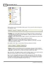
Page 19: ...of the main window You can also right mouse click over any map to access map functions in a faster way including setting you home location On these menus there are several map layers that you can cho...

Page 20: ...s received by your decoder Other types of alerts are available 9 In addition to the 5 tabs you can also access the MyLog and Reporter functions MyLog a collection of all live flights received by your...

Page 21: ...red in a queue for upload to the AirNav server Data is then uploaded 5 minutes after it has been received On our server we have a powerful application called AirNav Network Server which processes up t...

Page 22: ...AirNav RadarBox Manual 22 Copyright 2010 by AirNav Systems Above RadarBox Live data being displayed...

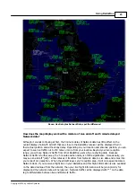
Page 23: ...Beyond your live reception range you will see Network traffic from other RadarBox users who are sharing data Because Network traffic is further away the 5 minute position delay is of little significan...

Page 24: ...AirNav RadarBox network you need to have your RadarBox hardware receiver connected to your computer by the USB cable Run the RadarBox software if it not already open go to the Network tab and check th...

Page 25: ...but the Mode S codes are correctly detected by RadarBox as 40107A 401229 and 401294 When you left click on one of these unpopulated aircraft lines RadarBox will connect to the online database and if...

Page 26: ...ert function You can program the software to trigger alerts for a number of circumstances see below for more details For example you can have the program to automatically send an email message when Br...

Page 27: ...ypes of conditions to trigger an alert Mode S when an aircraft with a specific mode s has been received an alert is triggered Registration when a specific registration is received Range when a flight...

Page 28: ...the registration condition all the British registered aircraft registrations start with a G On the bottom of the Alert tab you will also see the alert log box This will keep a log of the alerts Examp...

Page 29: ...etected First date and time the aircraft was detected in the format 200712011255 Year month day hour minute seconds Last date and time the aircraft was detected Comments entered by user When the aircr...

Page 30: ...e BaseStation sqb file Export to CSV Exports to a comma delineated file for import into MS Excel or MS Access Populate Checks both the the online AirNav database and the internal Radarbox database and...

Page 31: ...ime order Above Report creator window How to send a report 1 Select Data to include in the report First you need to specify the data range for the report the choices are today s entries or yesterday s...

Page 32: ...801 EGLL GMMN GMMX CN ROR B738 Royal Air Maroc 2009 07 01 17 38 29 4910C7 NJE982K EGWU LIPX CS DFG F2TX Untitled NetJets 2009 07 01 16 08 09 49124A NJE889 CS DRJ H25X Untitled NetJets 2009 07 01 17 38...

Page 33: ...Ryanair 2009 07 01 17 29 02 4CA202 RYR16EW EPWR EGNX EI DCC B738 Ryanair 2009 07 01 17 39 16 New Aircraft entries have the symbol End of Report Note If you require more specific data use MyLog and th...

Page 34: ...he map by using the filters utility It can be accessed on the filter toolbar at the top of the application main screen Advanced filters are also available by clicking the Advanced filter tool button T...

Page 35: ...filters are those that show all aircraft not including the ones that match your negative filter See the example below Note that if you do not know the airline airport or aircraft codes to specify on f...

Page 36: ...aircraft registrations or airline ID can be entered with being used as a wildcard to allow groups of aircraft to be seen Click Apply Changes to activate When the SmartView tab is selected see above o...

Page 37: ...window is the Select Airport option This allows weather for a specific airfield to be displayed and for the map to be centered on that airfield The QNH atmospheric pressure at airfield level adjusted...

Page 38: ...nnss Mode S HEX Code Callsign Altitude in feet Groundspeed Track Vertical Rate in feet per minute Airspeed Latitude Longitude Examples PTA 20070516163432224 40056E TOM287Q PTA 20070516163432739 C076F0...

Page 39: ...how red 3 If at anytime you want to monitor all the airspace again click the Airport button to uncheck it 4 The Origin and Destination buttons can be used in the same way to view specific flights to a...

Page 40: ...rk in conjunction with AirNav ACARS Decoder Decoder is a separate program available from AirNav This way you will be able see ACARS messages for the flights you are tracking AirNav RadarBox is the fir...

Page 41: ...it will detect if AirNav ACARS Decoder is running and if that is the case connect to it automatically If ACARS Decoder was started after RadarBox then Select Connect to AirNav ACARS Decoder in the Rad...

Page 42: ...ion With ACARS such routine items as departure reports arrival reports passenger loads fuel data engine performance data and much more can be requested by the company and retrieved from the aircraft a...

Page 43: ...e we see a downlink response to an uplinked weather report sent by crew request or automatically by the flight operations ACARS mode 2 Aircraft reg N651UA Message label H1 Block id 3 Msg no D89A Fligh...

Page 44: ...RA IAD 2214 2249 887A SWANN 2259 37 849 BROSS 2301 37 839 OOD 2307 37 815 RBV 2312 37 801 ACK 2337 37 757 WHALE 2354 37 728 BANCS 0108 37 23 07 1997 22 51 Waypoints are shown in the left hand column j...

Page 45: ...21 28214 958 TS2155 16 100897B166 10 08 1997 21 55 This is a good example of a position report along the aircraft s flight route In this case United flight 970 is a North latitude 39 09 2 and West lon...

Page 46: ...t to the right Set map to Resize map to full window extents Zoom in Zoom out Zoom Back Zoom Forward Pre defined Map Colors you can define them in the preferences window Satellite Layer download save a...

Page 47: ...use button 2 Move your mouse to resize the map as desired See Custom Outline Maps in the Advanced Users section for information on displaying custom maps Avoid Label Overlap You can avoid aircraft lab...

Page 48: ...e Map Type KMIA airport ICAO code for Miami on the locate white box and click Locate 4 1 4 Weather Toolbar Weather Toolbar This feature enables you to quickly find airport weather conditions Informati...

Page 49: ...Menus Windows and Toolbars 49 Copyright 2010 by AirNav Systems METAR for EGLL TAF for EGLL Decoded Metar for EGLL 4 1 5 Filters Toolbar Filters Toolbar...

Page 50: ...The filters toolbar allow you to select what flights are shown on the map By default all the flights will be shown For more information on how to use filters please go to Using Filters section 4 2 Rad...

Page 51: ...ortant areas of the software after the map display Here you can view detailed information on each flight being received The MyFlights Tab shows local flights received by your hardware The Network Tab...

Page 52: ...in feet minute Company Airline Name Route Origin Via Destination in ICAO 4 letter code Flying Over Region the flight is overflying Latitude Longitude You can choose which columns are seen on the grid...

Page 53: ...Information received using the DDE connection is shown Note that on the MyFlight and Network Grids a small ACARS Symbol will appear on a flight if ACARS information is being received for that flight...

Page 54: ...to Folder button opens the folder where aircraft photos are stored in Windows Explorer The Aircraft Grid columns show Mode S Aircraft Type Registration ACARS Mode Aircraft Type ICAO Code Aircraft Name...

Page 55: ...o pictures of the selected are shown on the right dependant on Preference settings 4 2 4 Alerts Alerts Tab One of the most useful features of AirNav RadarBox is the ability to send an email message re...

Page 56: ...entries and then click the Generate button Then you can opt to save your report by copying it to the Windows clipboard or by saving it to a file A Draft of the generated report is shown on the Report...

Page 57: ...the bottom left of the Database Explorer Window the total number of records on the current active table is shown The aircraft section of the database is automatically populated when new aircraft are...

Page 58: ...llows the automatic FTP upload of a jpg screen shot to a location of your choice The upload is delayed by 5 minutes in order to meet international restrictions on the display of live air traffic data...

Page 59: ...Menus Windows and Toolbars 59 Copyright 2010 by AirNav Systems Folder Folder for FTP picture on web domain e g dcroot radarbox RadarBox...

Page 60: ...aircraft routes will be auto populated from the Internet database Timeout for MyFlight set how long aircraft will be displayed after the signal is lost Timeout flights will be shown in a different col...

Page 61: ...right 2010 by AirNav Systems Home Location so when you click the Go to Home button on the main window this is properly centered Station Data details of your station which will be included on the Repor...

Page 62: ...0 by AirNav Systems Customize the way maps are drawn Left click on the color panel to change a map color If you wish to save your color settings for later use use Export to save the settings file in t...

Page 63: ...ws and Toolbars 63 Copyright 2010 by AirNav Systems Your custom color settings will then appear in the Map Toolbar drop down list Note that you can share your settings with a friend by sending them th...

Page 64: ...AirNav RadarBox Manual 64 Copyright 2010 by AirNav Systems Examples of custom color settings...

Page 65: ...Menus Windows and Toolbars 65 Copyright 2010 by AirNav Systems...

Page 66: ...AirNav RadarBox Manual 66 Copyright 2010 by AirNav Systems 4 3 Menus 4 3 1 File File Menu...

Page 67: ...Menus Windows and Toolbars 67 Copyright 2010 by AirNav Systems Screen Shot Create Save Share and Explore Screen Shots...

Page 68: ...v Systems Above Screenshot created by RadarBox Play Recorded File See the Recorder Replay section Database Explorer See the Database Explorer section Preferences Opens the preferences window Click her...

Page 69: ...ase read the Using Filters section New Filter Clears the filter being used and creates a new one Open Filter Reads a Filter file saved in a file and loads it into the active view Save Filter Saves the...

Page 70: ...ad a previously downloaded satellite image The satellite layer works in just the same way as the normal map window except that the area covered by the satellite picture only covers the current area of...

Page 71: ...Menus Windows and Toolbars 71 Copyright 2010 by AirNav Systems All the usual map overlays are available although you may wish to create and save a new colour scheme for use with satellite overlays...

Page 72: ...ircraft lists or menu bars Press the Esc key to return to the normal view All other map functions are self explanatory More than 500 thousand map features are available aviation and non aviation relat...

Page 73: ...etwork aircraft list SmartView View the SmartView tab to access the Fleet Watch and auto QNH settings ACARS View ACARS information Requires additional AirNav ACARS Decoder software Alerts View the Ale...

Page 74: ...s all the open windows to be tiled horizontally vertically map or vertical tracking windows Cascade Rearranges all opened windows map and vertical tracking in AirNav RadarBox 2009 so they overlap Arra...

Page 75: ...0 by AirNav Systems Contents Opens Help File Contents Online Support Get support in less than 24 hours using our online support ticketing system Forum Join the online AirNav community to discuss Radar...

Page 76: ...am updates and news Check for Updates If you are connected to the Internet click here to download program patches updates Welcome Opens the AirNav RadarBox 2009 Welcome Window About Opens the program...

Page 77: ...craft Military aircraft do not normally transmit position information however they do sometimes show up in the MyFlights aircraft list In this example two military aircraft are being picked up but are...

Page 78: ...RadarBox systems files Changes you make might prevent RadarBox from functioning correctly or might stop it from working altogether In the worst case be prepared to uninstall and reinstall RadarBox to...

Page 79: ...er Hex code with wildcards for the UK All UK Mode S codes start with Bin 010000 a sweeping generalization but you get the idea When RadarBox detects a Mode S Binary 010000 then it shows the UK BMP in...

Page 80: ...file not the one you have just saved as a copy and you will see that the file is in this format but has many more lines AF Afghanistan 011100000000 AL Albania 01010000000100 DZ Algeria 000010100 AO An...

Page 81: ...saved as a txt file so don t use Word or Wordpad any other program and it must be named D008 dat and NOT D008 dat txt which might happen if you use Save as Look at the file in Explorer to make sure th...

Page 82: ...files are used to draw maps on the RadarBox map screen Maps can consist of airways airpace or airfields Above Detailed airspace outline map around London Heathrow Airport Once you have downloaded or...

Page 83: ...ound in Preferences Colors To hide Outlines go the RadarBox Map Menu and untick Outlines or delete the specific outline file from the Outlines folder Above Detailed airport outline map London Heathrow...

Page 84: ...eue 3 There is a timer permanently checking the queue for messages older than 4 minutes 59 seconds If there are messages in this condition they are deleted from the queue and added to the output port...

Page 85: ...is at the edge of reception cover sometimes it will not be detected when the screen refresh is due If the aircraft is not detected then it will be marked for timeout after the set time expires The ai...

Page 86: ...s shown that the figures in the diagram above work well 30 seconds and 60 seconds for MyFlights and 35 seconds and 60 seconds for Network Flights 6 Troubleshooting 6 1 Hardware Connection Hardware Con...

Page 87: ...Control Panel System menu Under Universal Serial Bus Controllers look for the AirNav RadarBox driver If the driver is not present you will need to reinstall the driver AirNav RadarBox USB Driver pres...

Page 88: ...ed to your computer and your computer must have an Internet connection Open the RadarBox Interface if not already open and go to the Network tab and make sure that the Get flights from RadarBox Networ...

Page 89: ...flights without an internet connection but only flights within line of sight of the RadarBox antenna will be detected The maximum detection range for live flights is approximately 200 nautical miles R...

Page 90: ...7 1 How to Order How to Order To buy AirNav RadarBox 2009 please visit AirNav Systems web site at http www airnavsystems com and click on the Buy Now link on the top There are several ways to order f...

Page 91: ...emonstration of the program capabilities by clicking the Start Demo button For information on how to order AirNav RadarBox 2009 please go to How to Order 8 RadarBox 3D RadarBox 3D AirNav RadarBox 3D i...

Page 92: ...AirNav RadarBox Manual 92 Copyright 2010 by AirNav Systems Above Traffic leaving the UK heading out across the Atlantic Above RadarBox 3D Full Screen View British Airways B744...

Page 93: ...ays BAW295 Boeing B772 8 1 RadarBox 3D Menu Options Menu Options The RadarBox 3D view settings are accessible via the 3D View button on the main menu bar Above The 3D View settings Menu View options f...

Page 94: ...lable by right clicking on the aircraft in the MyFlights and Network aircraft lists Above Right click on an aircraft in the list to see 3D view options Left Clicking on an aircraft in the 3D view will...

Page 95: ...av Systems Above Left click on an aircraft in the 3D view to see more details You can display both the 2D and 3D views at the same time by using the RadarBox main menu buttons Above Click on the Split...

Page 96: ...AirNav RadarBox Manual 96 Copyright 2010 by AirNav Systems Above 2D and 3D views can be zoomed and panned independently...

Page 97: ...RadarBox 3D 97 Copyright 2010 by AirNav Systems Above use the External KML Manager to load Google Earth overlay files...

Page 98: ...opyright 2010 by AirNav Systems Above A Google Earth kml file of UK airspace being displayed in the 3D view 8 2 3D View Settings 3D View Settings Access the RadarBox 3D View settings via the 3D View m...

Page 99: ...RadarBox 3D 99 Copyright 2010 by AirNav Systems The 3D View tab in the Preferences window gives access to the 3D Viewing options...

Page 100: ...processing power and will require a high specification PC The Medium and Minimum settings allows less powerful PC s to display the 3D window Selecting Maximum Minimum or Medium settings will automatic...

Page 101: ...RadarBox 3D 101 Copyright 2010 by AirNav Systems Above At Medium setting 2D aircraft models are displayed...

Page 102: ...AirNav RadarBox Manual 102 Copyright 2010 by AirNav Systems Above With Minimum selected aircraft icons are shown rather than 2D 3D models...

Page 103: ...le Earth view 3 Use 3D Aircraft Models if available If this is selected RadarBox 3D will display aircraft as detailed 3D models If it is left unticked then 2D aircraft symbols will be used Note that u...

Page 104: ...hen an aircraft is selected a trail behind the aircraft and down to ground level is displayed Normally when a new aircraft is selected the trail transfers to the new aircraft If this option is ticked...

Page 105: ...tmospheric pressure difference Experiment with this setting to achieve the desired effect 2 Apply Offset This activates the Hardware Altitude Offset function 3 Scale Model Icon Proportionally to Altit...

Page 106: ...ight Search 50 FTP Auto Upload 57 Full Screen Mode 45 H Hardware Lights 13 Help 74 Help Menu 74 I Internet Connection 89 L Location Toolbar 47 Logon Window 90 M Maps Menu 69 Maps Toolbar 46 Military A...

Page 107: ......

Reviews: