


D
: The status of the internal oscillator of the GPS receiver.
DH
: not related to the user.
1
: DMS/DMD identifier. Letters for DMS, numbers for DMD.
0
: Parity. [0] for o, [E] for 1.
<CR><LF> end of the data
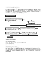
5-4-2 SMATC
This format is used for SONY’s car-navigation system “Columbus”. The GPS receiver by itself is
not yet available. Accordingly no further information is available, and NO DATA IS AVAILABLE
FROM SONY TO THE PUBLIC. DO NOT CONTACT SONY FOR DETAILS. The string with SMATC
and ends with <CR><LF>, fixed 130 bite fixed data. Similar information to “SONY” format would
likely be contained.
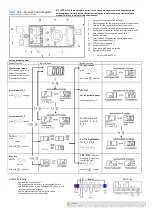
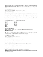
5-4-3 $GPGGA
This is one of NMEA-0183 compatible formats. The EJ-41U can analyze and re-structure this
format.
It starts with $GPGGA followed by the numbers. They indicate:
GPGGA - Global Positioning System Fix Data
String: $GPGGA,123519,4807.038,N,01131.324,E,1,08,0.9,545.4,M,46.9,M, , *42
123519 Fix taken at 12:35:19 UTC
4807.038,N Latitude 48 deg 07.038' N
01131.324,E Longitude 11 deg 31.324' E
1 Fix quality: 0 = invalid
1 = GPS fix
2 = DGPS fix
08 Number of satellites being tracked
0.9 Horizontal dilution of position
545.4,M Altitude, Meters, above mean sea level
46.9,M Height of geoid (mean sea level) above WGS84
ellipsoid
(empty field) time in seconds since last DGPS update
(empty field) DGPS station ID number
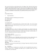
5-4-4 $GPVTG
One of the NMEA-0183 formats. Only the speed and direction can be detected. The EJ-41U can
analyze and re-structure this format.
The data contains the following information: