User manual
© Amberg Technologies, 2018
Page 63 of 68
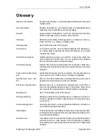
Glossary
Absolute coordinates
Position described by a coordinate triple of Easting, Northing and
Height values
Axis coordinates
Position described by a coordinate triple of Chainage/Heading
stationing, Horizontal offset and Vertical offset.
Azimuth
Angle between cartographic north and measurement direction
defined clockwise. Zero is equal to north direction.
Chainage
Stationing value along a chainage axis as a reference of the fin-
ished structure, e.g. railway or highway axis
Chainage axis
Axis in Structure view of the project
Construction
Top node for all sites, tube and shaft headings with heading ax-
es, design data, measurement data and analyses of a project
(Construction view)
Construction progress
Heading stationing value up to which a construction stage has
been finished at a certain time, e.g. the position of the heading
face for the Excavation construction stage
Construction stage
Design of the tunnel at a certain stage of construction, holds theo-
retical profiles, theoretical sections and optional transverse slope
definition
Cross section based anal-
ysis
Geotechnical analysis type for evaluation of measurements per
cross section. Each cross section is analysed separately
Geotechnical cross sec-
tion
Place in the tunnel defined by a heading stationing value where
geotechnical measurement points are installed
Erroneous measurement
Measurement of a geotechnical measurement point that is
known to be probably wrong but kept in the system. Flag can be
set to ignore the measurement in all calculations and display
Heading axis
Axis in Construction view of the project
Heading stationing
Stationing value along a heading axis as a reference during con-
struction, usually zero at the tunnel portal and increasing in head-
ing direction.
Horizontal alignment
Geometry of an axis in a horizontal plane defined by straight, arc
and clothoid elements (Situation)
Interpolation
Theoretical section with different start and end theoretical profile.
Intermediate theoretical profiles are generated depending on the
input theoretical profiles
Location code
User defined code to describe the location of a geotechnical mea-
surement point in a cross section. Used for labeling in graphics
and selecting the appropriate measurement points in longitudinal
analysis
Summary of Contents for Tunnel 2.0 - Tunnelscan
Page 2: ......
Page 6: ...Page 6 of 68 ...
Page 10: ...Page 10 of 68 ...
Page 12: ...Page 12 of 68 ...
Page 26: ...Page 26 of 68 ...
Page 62: ...Page 62 of 68 ...
Page 66: ...Page 66 of 68 ...
Page 67: ......


