126
|
Chapter 6
Using Reports to Query and Update Data Sources
Setting Up the Report in Autodesk MapGuide Author
We’ll start by specifying the report information in Autodesk MapGuide
Author. Our report will be called Incidents (ASP), and it will pass the lat/lon
coordinates of a user-specified point to server page whose URL is
http://www.yourserver.com/asp/getpoints.asp
.
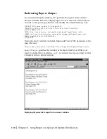
Dialog box specifications for Incidents (ASP) report
The following show how we used the options on the Reports tab:
■
Report
—Specifies the name of the report as it appears in the Autodesk
MapGuide Viewer. Our report is named Incidents (ASP).
■
URL
—Specifies the name and location of the report script, in this case
getpoint.asp
on
www.yourserver.com
.
■
Data
—We left this field blank but could have used it to pass additional
URL parameters to
getpoint.asp
.
■
Type
—Specifies whether the report is based on the keys of selected
features, or on the coordinates of a point the user clicks. We chose the
second option: Digitize a point and send point.
■
Prompt
—Specifies the text to be displayed in a message box prompting
users to specify a point. If this field is left blank, no message box is displayed.
When a user runs the Incidents (ASP) report, Autodesk MapGuide prompts
the user to specify a point, then invokes
getpoint.asp
, passing the point’s
lat/lon coordinates as URL parameters (more specifically, the coordinates are
sent as form data via the HTTP
POST
method). For example, if the user spec-
ified a point with coordinate values of 37.721,-121.943, the URL would be:
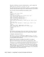
http://www.yourserver.com/getpoint.asp?LAT=37.721&LON=-121.943
Summary of Contents for 15606-011408-9300 - MAP R6.3 UPG
Page 1: ...15306 010000 5060 October 2001 Autodesk MapGuide Release 6 Developer s Guide ...
Page 6: ...vi ...
Page 16: ...16 ...
Page 30: ...30 ...
Page 84: ...84 ...
Page 134: ...134 ...
Page 202: ...202 ...


