Datalink (Optional)
Avidyne EX500/EX600 MFD
-96-
600-00078-001 Rev 05
Iridium Coverage Areas
If the aircraft is equipped with the MLX770 Iridium transceiver,
METARs and TAFs are available worldwide. See http://
www.avidyne.com/products/mlx/coverage/ for the latest coverage
information for all other 2-Way Datalink products.
ORBCOMM Coverage Areas
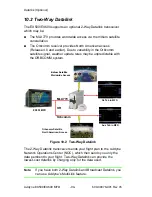
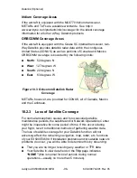
If the aircraft is equipped with the Quake SC internal transceiver, two-
Way Datalink provides datalink radar data within the contiguous
United States (CONUS) as well as portions of Canada and Mexico.
ORBCOMM coverage is bounded by the following limits:
●
North
: 52 degrees N
●
West
: 127 degrees W
●
South
: 22 degrees N
●
East
: 63 degrees W
Figure 10.3 Orbcomm Datalink Radar
Coverage
METARs, however, are provided for CONUS, all of Canada, Mexico
and the Caribbean.
10.2.3
Loss of Satellite Coverage
For normal atmospheric causes and for occasional satellite
maintenance periods, the satellite and/or Network Operations Center
might be inoperative for some period of time. If this occurs during
your flight, revert to traditional methods of gathering weather data.
The loss of satellite coverage for your Datalink function will not
adversely affect the remaining navigation, map, radar, etc. functions
of your EX500/EX600. If installation problems and/or satellite network
problems do occur, you will be able to determine this by observing:
●
That you are no longer receiving any weather or TFR data.
●
Your Satellite in view data field on the
Trip
page indicates
“NONE”
(this is normal for brief periods during normal
operations—usually no more than 5 minutes).
Summary of Contents for FlightMax EX500
Page 1: ...600 00078 001 Rev 05 Multi Function Display Pilot s Guide Software Release 4 or Later ...
Page 2: ......
Page 38: ...Map Page Avidyne EX500 EX600 MFD 26 600 00078 001 Rev 05 THIS PAGE INTENTIONALLY LEFT BLANK ...
Page 90: ...Trip Page Avidyne EX500 EX600 MFD 78 600 00078 001 Rev 05 THIS PAGE INTENTIONALLY LEFT BLANK ...
Page 183: ......


