IFD400 Series Pilot Guide
4-60 Aux Subsystem
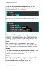
When the item is expanded and the layer is
“On”, the set of
conditions for that layer are shown. However, if the layer is off,
none of the other conditions are shown.
Once the layer is turned “On”, the set of conditions applicable to
that layer are revealed.
Like the airport filter, the layout and wording of conditions within a
map layer is designed to make the set of conditions read like a
sentence. The sentence is structured to clearly specify the set of
conditions that must be met in order for items in the layer to be
shown. Each of the possible criteria is described in the sections
below.
Map layers have several possible default settings either
corresponding to the intended mission or “factory” default. See
the “Presets” section for a discussion of those default settings.
Labels
The labels criterion specifies whether items are displayed on the
map with an associated label. The label generally contains the
identifier of the item being displayed.
Range
The range criterion specifies the maximum map range at which
items in the layer will be displayed. At or below that range, items
will be displayed. Above that range, they will not.
Summary of Contents for IFD410 FMS/GPS
Page 1: ......
Page 8: ......
Page 56: ......
Page 100: ...IFD400 Series Pilot Guide 2 44 FMS Subsystem Info Tab Nearby Navaids ...
Page 160: ......
Page 250: ...IFD400 Series Pilot Guide 4 90 Aux Subsystem ADS B Unavailable Products Page ...
Page 252: ......
Page 378: ......

