IFD500 Series Pilot Guide
Map Subsystem
4-5
NOTE
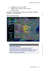
Heading vs. Track Depictions
In configurations in which aircraft heading information is
unavailable, the map display will orient the aircraft
ownship symbol and other map data to the aircraft
ground track and continue to display intruder aircraft
oriented to heading.
TIPS AND TECHNIQUES
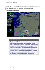
Heading/Track Digital Display Can Be Removed
The Setup Page provides a means to remove the
heading/track digital readout box from the top of the
map. This is intended to provide a method to increase
usable map space, especially on dual IFD installations
where cleaner maps are desired.
NOTE
Map Orientation Without GPS
The map orientation will auto-switch from track-up
orientation to north-up orientation when GPS is lost.
Pilots who leave the map orientation in track-up during
shutdown may notice the map will start up in north-up
until a GPS position fix is available, at which time the
map will auto-switch to track-up.
NOTE
Terrain Resolution
The IFD uses either 3 or 9 arc-second terrain data for
the map. There are however, some locations where the
terrain database fills in missing terrain cell data and the
map terrain will visually appear to be a lower resolution
background in those locales.
Summary of Contents for IFD510
Page 1: ......
Page 140: ...IFD500 Series Pilot Guide 3 50 FMS Subsystem Weather Data on Info Tab Info Tab Nearby Navaids ...
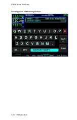
Page 150: ...IFD500 Series Pilot Guide 3 60 FMS Subsystem User Waypoint Airfield Naming Example ...
Page 156: ......
Page 180: ...IFD500 Series Pilot Guide 4 24 Map Subsystem ADS B Lightning Coverage Area Shadow ...
Page 252: ...IFD500 Series Pilot Guide 5 16 Aux Subsystem Trip Statistics Calculator ...
Page 460: ...IFD500 Series Pilot Guide 7 82 General Bluetooth pairing pairing code ...

