IFD500 Series Pilot Guide
Map Subsystem 4-43
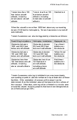
Terrain less than 100
feet below aircraft
altitude, including
terrain above aircraft
altitude
Terrain less than 100
feet below aircraft
altitude, including
terrain above aircraft
altitude
Hatched red
When the aircraft is more than 3000 feet above any surrounding
terrain (1500 feet for helicopters), Terrain Awareness is turned off
automatically.
Terrain Awareness can also be triggered by obstacles as follows:
Fixed Wing Installation
Helicopter Installation
Displayed As
Obstacles between
1000 and 2000 feet
below aircraft altitude
Obstacles between
500 and 2000 feet
below aircraft altitude
Cyan threat
bubble over
the obstacle
Obstacles between
100 and 1000 feet
below aircraft altitude
Obstacles between
100 and 500 feet
below aircraft altitude
Yellow threat
bubble over
the obstacle
Obstacles less than
100 feet below aircraft
altitude, including
above aircraft altitude
Obstacles less than
100 feet below
aircraft altitude,
including above
aircraft altitude
Red threat
bubble over
the obstacle
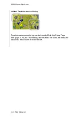
Terrain Awareness coloring is inhibited in an area immediately
surrounding airports to allow for enhanced visual distinction of those
facilities. If the orientation of runways at the airport can be
determined, then the inhibited area will be based on the outlines of
the runways. Otherwise, coloring will be inhibited in a circular area
around the airport, including airports that have been designated as
an airfield (see page 3-59).
Summary of Contents for IFD510
Page 1: ......
Page 140: ...IFD500 Series Pilot Guide 3 50 FMS Subsystem Weather Data on Info Tab Info Tab Nearby Navaids ...
Page 150: ...IFD500 Series Pilot Guide 3 60 FMS Subsystem User Waypoint Airfield Naming Example ...
Page 156: ......
Page 180: ...IFD500 Series Pilot Guide 4 24 Map Subsystem ADS B Lightning Coverage Area Shadow ...
Page 252: ...IFD500 Series Pilot Guide 5 16 Aux Subsystem Trip Statistics Calculator ...
Page 460: ...IFD500 Series Pilot Guide 7 82 General Bluetooth pairing pairing code ...

