


IFD500 Series Pilot Guide
Map Subsystem 4-59
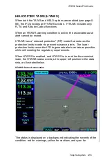
Map SVS
– Terrain Awareness and FLTA Coloring
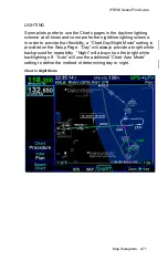
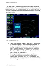
FLIGHT PLAN DISPLAY
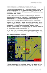
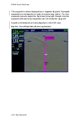
The display of the flight plan on the Map SVS view is controlled by an
LSK titled “FPL”. When the FPL selection is “Off”, the flight plan legs
will not be overlayed on the Map SVS view.
When the FPL selection is “On”, the FMS flight plan will be overlayed
on the Map SVS view. The flight plan legs are displayed
approximately 300 meters below the aircraft altitude and will also
cast a conformal shadow across the terrain immediately below the
flight plan. Any part of a flight plan leg that would be drawn below
ground level, will not be shown. As a result, the flight plan may
appear to go underground when descending or over variable terrain.
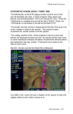
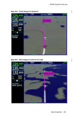
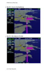
When the FPL selection is “Shadow”, only the conformal shadow will
be shown.
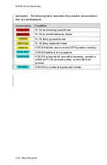
Flight plan legs are depicted using the same styles as on the 2D map
view. That is, the active leg is depicted in solid magenta, the next leg
is a candy-striped magenta/white depiction, downpath legs are
depicted in white, and inactive missed approach legs are shown in
dashed white.
Summary of Contents for IFD510
Page 1: ......
Page 140: ...IFD500 Series Pilot Guide 3 50 FMS Subsystem Weather Data on Info Tab Info Tab Nearby Navaids ...
Page 150: ...IFD500 Series Pilot Guide 3 60 FMS Subsystem User Waypoint Airfield Naming Example ...
Page 156: ......
Page 180: ...IFD500 Series Pilot Guide 4 24 Map Subsystem ADS B Lightning Coverage Area Shadow ...
Page 252: ...IFD500 Series Pilot Guide 5 16 Aux Subsystem Trip Statistics Calculator ...
Page 460: ...IFD500 Series Pilot Guide 7 82 General Bluetooth pairing pairing code ...