IFD500 Series Pilot Guide
Map Subsystem 4-69
CHART VIEWS
If the currently displayed chart is not the desired one, use the “Select
Chart” LSK to jump back to the Directory List where the desired
airport/chart can be selected.
Once a chart is displayed, the left-hand LSKs provide means to alter
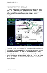
the view or presentation of the chart. A “Chart” LSK is provided to
select Airport or Procedure t
ype charts. The “View” LSK provides a
set of views to choose from based on which option was selected in
the “Chart” LSK. For example, if Procedure was picked, then one of
five chart views can be selected (Plan, Header, Profile, Minimums,
All). If Airport was selected, then a slightly different set of chart views
could be selected (Plan, Header, Runways, Departure, All). The
chart can be zoomed in and out, as desired, by using the right-hand
knob on the IFD or via a pinch-zoom touch method.
Summary of Contents for IFD510
Page 1: ......
Page 140: ...IFD500 Series Pilot Guide 3 50 FMS Subsystem Weather Data on Info Tab Info Tab Nearby Navaids ...
Page 150: ...IFD500 Series Pilot Guide 3 60 FMS Subsystem User Waypoint Airfield Naming Example ...
Page 156: ......
Page 180: ...IFD500 Series Pilot Guide 4 24 Map Subsystem ADS B Lightning Coverage Area Shadow ...
Page 252: ...IFD500 Series Pilot Guide 5 16 Aux Subsystem Trip Statistics Calculator ...
Page 460: ...IFD500 Series Pilot Guide 7 82 General Bluetooth pairing pairing code ...

