IFD500 Series Pilot Guide
5-44 Aux Subsystem
Datablock Item Title
and Image
Content
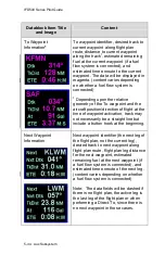
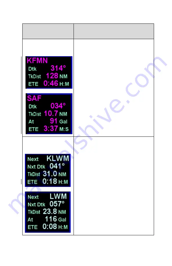
To Waypoint
Information
*
To waypoint identifier, desired track to
current waypoint along flight plan
route, distance to current waypoint
along the track
1
, estimated remaining
fuel at the current waypoint (if a fuel
flow system is connected), and
estimated time enroute to the current
waypoint. The data will be displayed in
magenta. (content varies depending
on whether a fuel flow system is
connected)
1
Depending upon the relative
geometry of the To waypoint and the
aircraft position/direction of flight at the
time of waypoint activation, track may
not necessarily be a straight line but
include a button hook at the beginning.
Next Waypoint
Information
Next waypoint identifier (the next leg of
the flight plan, not the current leg),
desired track to next waypoint along
flight plan route, flight plan leg distance
for the next waypoint, estimated
remaining fuel at the next waypoint (if
a fuel flow system is connected), and
estimated time enroute of the next leg.
(content varies depending on whether
a fuel flow system is connected)
Note: The data fields will be dashed if
there is no flight plan, the active leg is
the last leg of the flight plan or when
performing a Direct-To, since there is
no next waypoint in those cases.
Summary of Contents for IFD510
Page 1: ......
Page 140: ...IFD500 Series Pilot Guide 3 50 FMS Subsystem Weather Data on Info Tab Info Tab Nearby Navaids ...
Page 150: ...IFD500 Series Pilot Guide 3 60 FMS Subsystem User Waypoint Airfield Naming Example ...
Page 156: ......
Page 180: ...IFD500 Series Pilot Guide 4 24 Map Subsystem ADS B Lightning Coverage Area Shadow ...
Page 252: ...IFD500 Series Pilot Guide 5 16 Aux Subsystem Trip Statistics Calculator ...
Page 460: ...IFD500 Series Pilot Guide 7 82 General Bluetooth pairing pairing code ...


