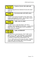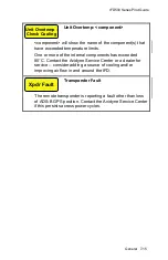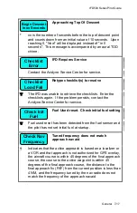
IFD500 Series Pilot Guide
7-14 General
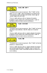
Traffic 4NM -200FT
*
The above alert is just an example. After "Traffic" will be
either "Low" or "High", then the distance in nautical miles.
The long text omits Low/High and instead shows signed
relative target altitude in feet.
This is a traffic advisory with no bearing information.
Establish visual contact with conflicting traffic in order to
facilitate avoidance maneuvers as necessary.
Traffic 12:00 3NM
*
The above alert is just an example. After "Traffic" will be the
bearing in clock direction, then the distance in nautical
miles.
This is a traffic advisory with no relative altitude information.
Establish visual contact with conflicting traffic in order to
facilitate avoidance maneuvers as necessary.
Traffic 2NM
*
The above alert is just an example. After "Traffic" will be the
distance in nautical miles.
This is a traffic advisory with no relative altitude information
and no bearing information. Establish visual contact with
conflicting traffic in order to facilitate avoidance maneuvers
as necessary.
Traffic 2NM
Traffic
12:00 3NM
Traffic
Low 4NM
Summary of Contents for IFD510
Page 1: ......
Page 140: ...IFD500 Series Pilot Guide 3 50 FMS Subsystem Weather Data on Info Tab Info Tab Nearby Navaids ...
Page 150: ...IFD500 Series Pilot Guide 3 60 FMS Subsystem User Waypoint Airfield Naming Example ...
Page 156: ......
Page 180: ...IFD500 Series Pilot Guide 4 24 Map Subsystem ADS B Lightning Coverage Area Shadow ...
Page 252: ...IFD500 Series Pilot Guide 5 16 Aux Subsystem Trip Statistics Calculator ...
Page 460: ...IFD500 Series Pilot Guide 7 82 General Bluetooth pairing pairing code ...


