IFD500 Series Pilot Guide
2-24 SVS Subsystem
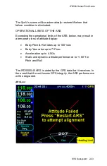
If the ARS data (mark pitch, roll and heading) becomes invalid,
the ARS page will display a red "X". Once the aircraft has
returned to straight and level flight, press the “Restart ARS”
button or soft key and maintain straight and level flight for at least
30 seconds.
NOTE
SynVis Unavailable During GPS Acquisition
SynVis depictions will not be available until the GPS
has reached SBAS or FDE state.
NOTE
Flight Plan Depictions
The depiction of the flight plan in any SynVis display
is placed 1000 feet below aircraft altitude. This
means that it will not be visible when flying under
1000 feet AGL during takeoff, enroute and approach
phases, nor will it be visible during ground
operations or may appear to go underground when
descending or when low over variable terrain.
Summary of Contents for IFD510
Page 1: ......
Page 140: ...IFD500 Series Pilot Guide 3 50 FMS Subsystem Weather Data on Info Tab Info Tab Nearby Navaids ...
Page 150: ...IFD500 Series Pilot Guide 3 60 FMS Subsystem User Waypoint Airfield Naming Example ...
Page 156: ......
Page 180: ...IFD500 Series Pilot Guide 4 24 Map Subsystem ADS B Lightning Coverage Area Shadow ...
Page 252: ...IFD500 Series Pilot Guide 5 16 Aux Subsystem Trip Statistics Calculator ...
Page 460: ...IFD500 Series Pilot Guide 7 82 General Bluetooth pairing pairing code ...

