BARTINGTON INSTRUMENTS
Page 10 of 61 OM1800/26
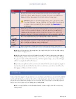
Mode
Function
Grid
The instrument can be used:
•
as a survey tool, where data is logged while covering the site in parallel
or zigzag paths. Data is saved in Grids of 10x10, 20x20, 30x30 or 40x40m.
The magnetic gradient is measured along a series of lines spaced at
0.25, 0.5 or 1m depending on the resolution required. Measurements are
taken at intervals of 0.125 to 1m along each traverse.
•
in scan mode, where the unit is used as a search tool with an audible
output for locating and tracing pipes, cables etc. without data logging.
See
Grid Mode
.
NMEA
NMEA Mode is designed for use with GPS hardware and features an NMEA
output. The Grid settings are not present and the logger will only run in scan
mode, called Run mode in NMEA Mode (see
Scan Mode (Grid Mode)
). NMEA
Mode has been added to data loggers with firmware version 7.1 and above,
and is purchasable as an upgrade to previous data logger versions if the
data logger is returned to Bartington Instruments.
In this mode data is not recorded but can be streamed to another device in
NMEA format, and is intended to be combined with a suitable GPS device
and logger. In this way the exact location of each reading can be recorded
against the data, removing the need to walk in Grids.
See
NMEA Mode
.


