background image


Mavic & Me Flight Planning  

© 2018-2019 BLACK CAT MEDIA / MAVIC & ME                                                                                   PAGE 5 


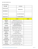
On-Site Survey: 

Job Number 


Date 


Client/Contact No. 


Wind Speed 


Remote Pilot 


Temp °C 


Observer 


Location 


CONTACT 

NUMBERS 

NOTES 

LOCAL ATC 


LOCAL POLICE 


LOCAL HOSPITAL 


OBSERVER 


PILOT 


ITEM 

CHECK 

FINDING 

OBSTRUCTIONS 

MASTS, WIRES, BUILDINGS, TREES, 

RIVERS, CANALS, INDUSTRIAL 


VIEW LIMITATIONS 

Anything that may impair VLOS? 


PEOPLE 

Crowd control Required? 


LIVESTOCK 

Animals, Wildlife 


TERRAIN 

Flat, Sloped, Rough, Wet, Icy 


PUBLIC 

Public Access? Signage Required? 


AIR TRAFFIC 

Clearance Required/Gained? 


PROXIMITY 

Adequate Separation from buildings, 

obstructions etc. 


TAKE OFF AREA 

Where is the safest convenient position 


LANDING AREA 

Where is the safest convenient position 


EMERGENCY AREA 

Where is the safest convenient position 


HOLDING AREA 

Where is the safest convenient position 


PERMISSION 

Landowner’s permission confirmed? 


BRIEF/ 

COMMUNICATION 

Brief Crew and Client(s). Issue Radios if 

Required 


Summary of Contents for MAVIC & ME

Page 1: ...Mavic Me Flight Planning V1 0...

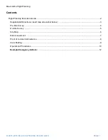
Page 2: ...1 Contents Flight Planning Execution Guide 2 Hospital A E Directions insert map screenshot below 3 Pre Site Survey 4 On Site Survey 5 Site Map 6 Risk Assessment 7 Proof of commercial insurance 8 Crew...

Page 3: ...Mavic Me Flight Planning 2018 2019 BLACK CAT MEDIA MAVIC ME PAGE 2 Flight Planning Guide The following pack has been created to help plan brief and execute UAV operations...

Page 4: ...Mavic Me Flight Planning 2018 2019 BLACK CAT MEDIA MAVIC ME PAGE 3 Hospital A E Directions insert map screenshot below...

Page 5: ...i Pads etc HAZARDS Live Firing High Intensity Radio Transmissions Gas Venting etc RESTRICTIONS Nuclear Power Stations Prisons etc SENSITIVITIES Recreational areas Local By Laws OBSTRUCTIONS Wires Buil...

Page 6: ...ir VLOS PEOPLE Crowd control Required LIVESTOCK Animals Wildlife TERRAIN Flat Sloped Rough Wet Icy PUBLIC Public Access Signage Required AIR TRAFFIC Clearance Required Gained PROXIMITY Adequate Separa...

Page 7: ...Mavic Me Flight Planning 2018 2019 BLACK CAT MEDIA MAVIC ME PAGE 6 Site Map...

Page 8: ...Mavic Me Flight Planning 2018 2019 BLACK CAT MEDIA MAVIC ME PAGE 7 Risk Assessment...

Page 9: ...Mavic Me Flight Planning 2018 2019 BLACK CAT MEDIA MAVIC ME PAGE 8 Proof of commercial insurance...

Page 10: ...ous Please do not approach the aircraft during take off or landing While the aircraft is in the air please be aware of it at all times If you hear me shout UAV FAIL at any time please find the aircraf...

Page 11: ...rate This is to be conducted prior to and after each flight and is to be documented each time in the aircraft logbook Start This is defined as the moment the RP takes the SUAS to the TOLP for the purp...

Page 12: ...f the landing procedure the Flight Crew are to ensure that any 3rd parties are moved to a minimum safe distance clear of the RP and the cordon area ideally behind the RP When conducting the landing pr...

Page 13: ...do so If the RP is unable to move the aircraft to a safe distance the RP should land the SUAS Low Battery Voltage Power Loss in Flight The control systems utilized in most SUAS means that a loss of ba...

Reviews: