TM
GE60 Installation Manual
580-00505, rev 0.4
9 of 30
PRELIMINARY
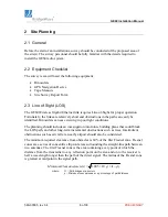
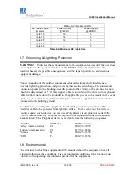
Path Length
(meters)
Minimum Clearance
(meters)
250 0.56
500 0.79
750 0.97
1000 1.12
Table 2-1: Minimum Clearance at Link Midpoint for various Path Lengths
2.4 Link Distance
Measurement of the link distance is important in estimating the link availability and
calculating expected Receive Signal Level (RSL). This measurement can be performed
using the Latitude and Longitude readings from a Global Positioning System (GPS)
device, which is placed near the proposed locations of the antennas, or using a range
finder device.
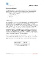
Table 2-2 below lists the maximum link distance with respect to desired availability and
ITU rain zone (ITU-R Recommendation PN.837). The map (Figure 2-1) following the
chart shows where the rain zones fit across North America and Asia for various
availabilities and most ITU rain zones.
Rain
Zone
Availability
A B C D E F K M N
99.7000% 837 817 807 787 812 787 787 727 697
99.9000% 817 802 782 752 772 752 717 652 592
99.9700% 782 772 742 712 717 697 647 572 497
99.9900% 752 717 697 672 652 622 567 502 437
99.9950% 717 677 647 632 592 552 502 452 392
99.9970% 702 657 587 617 567 527 487 437 377
99.9990% 652 602 567 567 487 467 427 402 337
Table 2-2: Maximum Link Distances (meters) for various Availabilities and Rain Zones


