Section 4 - MultiLogger Configuration
MLGPS-P
User's Guide
63
Satellite Tracking
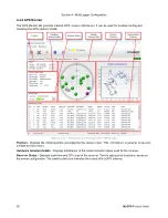
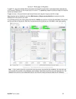
Chart
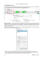
- Shows available satellites in the sky, their azimuth, elevation from horizon and
constellation status. The chart is synchronized with the Status column of the Channel Status Tracking table at
the bottom of the Monitor. The user can click a satellite in the chart and the corresponding record in the table
will be selected, and vice versa. Four Constellation Status icon colors may display in the chart:
green
,
grey
,
magenta
and
olive
. Only the green icon represents usable data for positioning. The icon will have the
associated satellite PRN as displayed in the Channel Status Tracking table.
▪
Green Constellation Status icon
‒ Indicates that the satellite is found, and time and frequency are
locked, or re-locking is in progress. Data is usable for positioning.
▪
Grey Constellation Status icon
‒ Indicates that the satellite's approximate location is known, but no
signal is received, or the satellite belongs to a different constellation and is not usable for positioning.
▪
Magenta Constellation Status icon
‒ Indicates that the received frequency is out of range or data is
otherwise unusable (e.g. almanac is out of date) for positioning.
▪
Olive Constellation Status icon
‒ Indicates that the satellite is in steering or frequency lock loop, so data
is not usable for positioning.
Position Tracking
tracks the position calculated by the receiver. Faded color is used for indication of earlier
data. A pink dot represents the current position. A light green triangle represents the Station Initial Position
defined within the Settings tab.
Channel Status Tracking
displays the receiver channels' statuses. Each channel is assigned for tracking one
satellite.
The maximum number of channels for the standard MLGPS unit is 14. Each column is explained as
follows:
▪
PRN
‒ This stands for the unique "pseudo-random noise" sequence transmitted by each satellite that
allows it to be differentiated from other satellites.
▪
Ch
‒ The channel number of the receiver that is receiving signal from the associated tracked satellite.
▪
GNSS
‒ The Global Navigation Satellite System that the satellite belongs to. The MLGPS is capable of
tracking L1 frequencies from two GNSS's; the American GPS and the Russian GLONASS.
▪
Elevation
‒ The tracked satellite's elevation above the horizon, from the unit's location.
▪
Azimuth
‒ The angle between the satellite and the North, from the unit's location. This is measured
clockwise.
▪
Signal Type
‒ The signal type being received from the tracked satellite. L1 C/A is the only signal that the
GPS receiver will use. L1 is the
carrier signal
. It is broadcast at 1575.42 MHz. C/A is the Course
Acquisition Code, which is one of the signals being broadcast on the L1 frequency. It is used to determine
pseudorange.
▪
Carrier/Noise
‒ The ratio of the signal strength of the carrier signal to the signal's noise.
▪
Pseudorange
‒ The pseudo distance between the satellite and the receiver, meaning it is a prediction that
will not be entirely correct due to a variety of errors which make a 100% correct calculation impossible.
▪
Doppler
‒ The difference in Hertz of the frequency received versus calculated, due to Doppler effects
(changes in frequency due to changes in distance between receiver and satellite). The processing engine
will provide corrections to the data based on the Doppler effects.
▪
Residual
‒ The difference between the calculated pseudorange measurements (using the position
solution) and actual measurements.
▪
Lock Time
‒ The number of hours of continuous tracking, without cycle slipping. Longer lock times allow
for better accuracy.
▪
Health
‒ Shows the health of the satellite's signal, as indicated by the NAV message.
▪
Status
‒ Shows the status of the reception of signal between the receiver and the satellite. This column is
synchronized with the Satellites Tracking Chart.

