57
12.13 Display All Routes
Select this option from the Routes Side Menu and the screen
zooms out far enough to temporarily display all routes that are
entered (unless the zoom limit is reached before they can all
be seen). The maximum chart scale is 500 nm.
12.14 Clear All Routes
Select this option only if you wish to delete all six routes.
When the
SELECT
key is pressed you will be asked to confirm
the instruction and given the chance to cancel.
12.15 Editing Waypoint Information
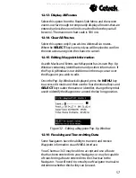
As with Marks and Events each Waypoint has its own Pop-Up
Window containing identification and position information. If
the Pop-Up Window is not visible move the map cursor over
the Waypoint you wish to edit.
Once the Pop-Up Window is displayed, press the
MENU
key
to access edit mode and then use the four directional keys and
SELECT
key to alter the name or identifier, change the symbol
used to identify the Waypoint or amend the lat/long position.
Figure 32 - Editing a Waypoint Pop-Up Window
12.16 Receiving and Transmitting Data
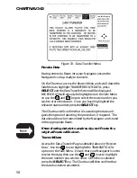
Some Navigators have the ability to transmit and receive
Waypoint information via an NMEA interface.
Your Chartnav 343 may be able to accept and use a Route
that has been entered into your Navigator, or may be capable
of transferring a Route entered into the Chartnav to the
Navigator. You will need to consult your Navigator manual to
determine whether this facility can be used.
All manuals and user guides at all-guides.com

