background image

Alto-G12 GPS 

Operating Instructions 

 
Introduction 

 
The units we have purchased are manufactured by Corvallis Microtechnology, Inc., a subsidiary 

of Hewlett-Packard.  The unit model is the “Alto-G12”.  If the units are used with the 
backpack, we can collect real-time differential data (no post processing).  If the units are used 

without the backpack, the data can be differentially post-processed later for sub-meter 
accuracy (using the base station data at http://www.uwsp.edu/cnr/acl ), or can be used as is 

with an accuracy of about 5m. 


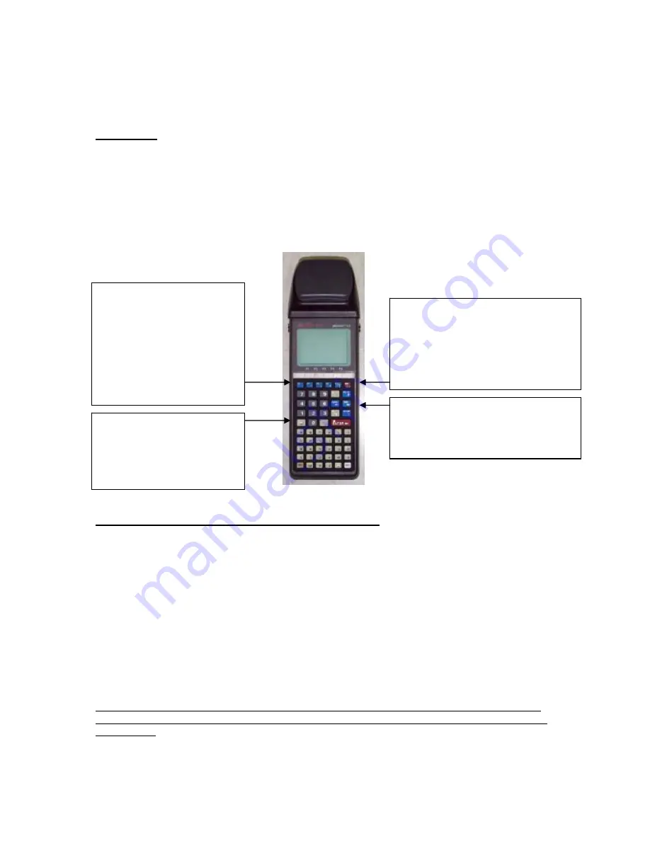
ON button.  If the unit is already on, 

press is again from any other screen 
to get to the Status report screen 

(info on current location, satellites, 
PDOP, battery charge status, etc).  

Press the ESC button to leave this 
screen. 

The ESC key moves you back 

one screen.  If you keep 
pressing it you will always 

end up at the main options 
screen. 

F1, F2, F3, F4, F5 function 

keys.  At the bottom of the 
display, you are often 

presented with a series of 
commands.  The position of 

the command corresponds 
to a function key.  Press the 

function key to use the 
command. 


ARROW keys.   Use the up and down 

arrows to move between 
options/fields.  Use the left and 
right arrows to change the option. 


Explanation of the Status codes in the upper right corner 
 

It is important to observe the status messages in the upper right of the screen. 
 

WAIT  The unit is busy and will not respond immediately to your commands. 
ACQ 

The receiver is acquiring signals from one or more satellites. 

TRK 

The receiver is tracking at least one satellite. 


For the following 4 digit codes, the fourth number (#) always represents the current PDOP.  A 
PDOP of 4.4 will appear as the number 5 (it rounds up). 
N2D#  The receiver is collecting data from 

 3 satellites, and can provide a 2D coordinate. 

N3D#  The receiver is collecting data from 

 4 satellites, and can provide a 3D coordinate. 

F2D#  The receiver is logging feature data to a file in 2D mode. 
F3D#  The receiver is logging feature data to a file in 3D mode. 

 
The D will become a C when the receiver is detecting the RTCM beacon signal that it uses for 

real-time differential.  If the code does not say N3C# or F3C#, then you are not collecting sub-
meter data.   Also, if the PDOP is greater than 6, the receiver will not log sub-meter data. 


1

Summary of Contents for ALTO-G12

Page 1: ...ion key Press the function key to use the command ARROW keys Use the up and down arrows to move between options fields Use the left and right arrows to change the option Explanation of the Status codes in the upper right corner It is important to observe the status messages in the upper right of the screen WAIT The unit is busy and will not respond immediately to your commands ACQ The receiver is ...

Page 2: ... The symptom of a low backpack battery is that the units will not detect any satellites and the status indicator in the top right of the screen will just say ACQ The battery should be fully charged before you check it out If you are just using one or two units I recommend checking out a spare backpack battery too we have 10 spare If the battery is connected it is being drained BE CERTAIN THAT THE ...

Page 3: ...er cable black must be plugged into a battery Unzip the backpack to access this cable Antenna cable black must be attached to white antenna Raise the antenna pole so that it is above the level of your head Three cables emerge from the top of the backpack two of which come over your left shoulder For real time sub meter locations attach the COM port cable to COM2 and the antenna cable to the connec...

Page 4: ...you may manually enter as many ATTRIBUTES and corresponding VALUES for your features as you wish A reasonable ATTRIBUTE for TREES may be SPECIES with a VALUE of OAK for instance 7 On the FEATURING screen press F4 STORE to begin collecting data For Points the screen will automatically return to the FEATURING screen after the point has been collected and stored Move to your next point change any att...

Page 5: ...ata collector in Automatic mode Use this procedure to transfer Job files FTR RAW DEF Feature List files FBR Route files PAT Waypoint files WPT Base files DIF Almanac files ALM or User defined Coordinate System files USER_COR SYS and USER_DAT SYS from a CMT GPS data collector in Automatic mode Please Note PC Mapper does not make use of Waypoint Files On the CMT GPS data collector 1 Connect your dat...

Page 6: ...ftr that you just transferred If you have multiple features contained in a single job file as will usually be the case the software will load them as separate themes 2 Select your coordinate system The bottom right of the screen will show you what the current coordinate system is i e the coordinate system the data was collected in Most Wisconsin data is in the WTM83 91 coordinate system so if you ...

Page 7: ...mmodate or you are measuring precise numbers you just leave the Values field blank and the user can type in the value manually at the time of collection Click on a blue box and start typing to fill in a field Remember to keep your words short e g 20 letters max Use the Insert button to add more lines you must fill in the first line before it will allow you to insert more See pages 66 69 in the PC ...

Page 8: ... File Name press Enter 4 Use the keys to select the feature type from the list Press Enter 5 Fill in the Value field for each of the attributes in the list If you are presented with a list of options use the keys to select the correct option and press Enter If there is no list use the keypad to type in the attribute value and press Enter 6 When you have completed all the attributes you will be abl...

Reviews: