Discrepancies that invalidate a procedure must be reported to Garmin
International. The affected procedure is prohibited from being flown using data
from the Navigation database until a new Navigation database is installed in the
airplane and verified that the discrepancy has been corrected.
Contact information to report Navigation database discrepancies can be found at
www.Garmin.com>Support>Contact Garmin Support>Aviation. Pilots and
operators can view navigation data base alerts at www.Garmin.com>In the
Air>NavData Alerts.
RNP APCH including “GPS”, “or GPS”, “RNAV (GPS)” and “RNAV (GNSS)”
instrument approaches using the Garmin integrated flight deck are prohibited
unless the pilot verifies and uses the current Navigation database. GPS based
instrument approaches must be flown in accordance with an approved instrument
approach procedure that is loaded from the Navigation database into the flight
plan by its name.
Not all published Instrument Approach Procedures (IAP) are in the Navigation
database.
Manual entry of waypoints using latitude/longitude or place/bearing is prohibited
for published RNP and RNAV routes.
Whenever possible, RNP and RNAV routes including Standard Instrument
Departures (SIDs) and Obstacle Departure Procedures (ODPs), Standard
Terminal Arrival (STAR), and enroute RNAV Q and RNAV T routes should be
loaded into the flight plan from the database in their entirety, rather than loading
route waypoints from the database into the flight plan individually. Selecting and
inserting individual named fixes from the database is permitted, provided all fixes
along the published route to be flown are inserted.
GNSS integrity limitations
For flight planning purposes, in areas where SBAS coverage is not available, the
pilot must check RAIM availability. The availability of GPS integrity RAIM shall be
confirmed for the intended route of flight.
In the event of a predicted continuous loss of RAIM of more than five minutes for
any part of the intended route of flight, the flight should be delayed, cancelled, or
re-routed on a track where RAIM requirements can be met.
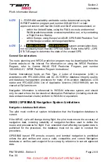
For flight planning purposes, in Remote Continental and Oceanic areas, the pilot
must check FDE availability. Refer to
, to check maximum authorized
FDE unavailability and WFDE Prediction program references.
Approach operations limitations
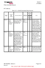
LNAV+V feature is a standard LNAV approach with advisory vertical guidance
provided for assistance in maintaining a constant vertical glidepath similar to an
Pilot's Information Manual
Section 2
Limitations
PIM TBM 960 - Edition 0
Rev. 00
Page 2.6.7
PIM - DO NOT USE FOR FLIGHT OPERATIONS

