l
Adding blocks to the flight, page 41
l
Viewing the flight summary, page 42
l
Simulating the flight, page 43
To remove a flight that is no longer required, select the flight and then click
below the list.
Note –
This removes the flight data stored on the tablet for this flight.
To rename a flight, select the flight in the list and then click the flight name. You can now edit the name.
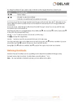
A flight can have the following status:
l
No icon: Not flown
l
Flown and settings frozen
l
Flown, log files downloaded and settings frozen
Note –
Flights with the status icon
or
cannot be renamed, changed, or removed. However, you can
copy the flight and then edit the copy.
Managing flight settings
To define the flight settings, in the flight menu tap
.
Rover and sensor
Select the type of aerial imaging rover and sensor you will use to fly.
Note –
This user guide is specifically for use with the UX5 HP aerial imaging rover. To use a different rover,
refer to the appropriate user guide.
The rover and sensor selection filters the blocks that can be added to the flight. For more information, see
Adding blocks to the flight, page 41
Communication timeout
The communication timeout value defines when the rover should activate the emergency pattern in case of
loss of the communication link.
l
Enter a value in the communication timeout field
between 20 seconds and 900 seconds
(15 minutes).
The default value is 120 seconds (2 minutes).
Note –
The country you are operating in may have regulations prescribing the minimum communication
timeout setting that you must use. Make sure you are aware of these and that you use the regulated
minimum setting for your location.
Geofence
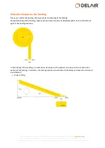
A geofence is a virtual perimeter around the GCS location. If there is no GCS location available, then the
takeoff location is used. The perimeter is defined by a radius and height.
When the rover reaches the geofence boundary, it starts the HERE pattern. For more information, see
Emergency software commands, page 88
.
To enable the geofence, select the flight in the list and then click
above the list. To disable the geofence,
click
above the list.
38
Delair-Tech
|
676, Rue Max Planck – 31670 Toulouse-Labège, France
|
Tel: +33 (0) 5 82 95 44 06
|
Capital: 238 110,30 € - APE: 3030Z – Intra-Community VAT number: FR90 53 09 69 781 – 530 969 781 R.C.S. Toulouse
This document is the sole property of Delair-Tech and cannot be used or reproduced without the written authorization of Delair-Tech
.


