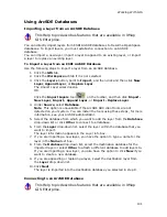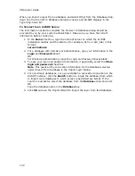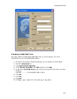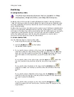
Working With GIS
111
File Types That Do Not Contain Spatial Reference Information
Supported spatial file types that do not contain spatial reference information include:
•
ESRI Shapefiles (.shp) that do not have an accompanying Projection file (.prj)
•
All file types marked with * above
Required parameters for this file type:
XMapimport
--target-server=
SQL Server
--target-db=
OpenSpace DB
--source-file=
file and path
OR, for ArcSDE import, --source-
sde=
[server,instance,database,login,password]
--datum=
datum
**
--coordinate-system=
coordinate system
**
If the coordinate system is UTM, you must specify two additional parameters in the
command line:
--utm-zone-number=
zone-number
***
--utm-band-letter=
band letter
***
If the coordinate system is SPCS, you must specify two additional parameters in the
command line:
--spcs-zone=
zone
**
--spcs-units=
units
***
** obtain valid options for these parameters by running a separate command in the
command prompt.
*** valid options for these parameters are listed in the instructions that display
when running xmapimport in the command line.
Optional Parameters include:
--layer-name=
name of the layer to be created
--replace-layer
=name of the layer to be replaced
--append-layer
=name of the layer to append to
Viewing a List of Supported Coordinate Systems
Type xmapimport --list-coordinate-systems to see a list of supported coordinate
systems. All files are converted to the Latitude/Longitude coordinate system with the
World Geodetic System datum during import.
Note that the list of supported coordinate systems is for spatial file types that do not
contain spatial reference information. For spatial file types that do contain spatial
reference information, the XMap Import Command Prompt is able to convert from a
much larger library of coordinate systems.
Viewing a List of Supported Datums
Type xmapimport --list-datums to see a list of supported datums.
Note that the list of supported coordinate systems is for spatial file types that do not
contain spatial reference information. For spatial file types that do contain spatial
reference information, the XMap Import Command Prompt is able to convert from a
much larger library of coordinate systems.
Summary of Contents for XMap 6
Page 8: ......
Page 361: ...Using Voice Navigation and Speech Recognition 353 Approaching finish Off route ...
Page 428: ......

