background image

4.4 Dead Reckoning

4.5 Autopilot

This function is automatically entered if the GPS sensor does suspends
transmission of valid fixes. New estimated positions are calculated
from previous valid speed and direction data. Coordinates will blink
and change color to red and every 5 seconds a beep will sound. After
2 minutes of continuous lack of GPS signal Dead Reckoning is
disabled and no navigation data will be presented and 3 consecutive
beeps will sound. If a GOTO or ROUTE was active it will be frozen until
valid fixes will be received again.

With Autopilot ON, NMEA 0183 format data for route correction and
following is sent on pin 2 of the 6 pin GPS connector. If an Autopilot is
connected the aircraft will be automatically directed to the Active
waypoint.Whenthisfunction is enabled the letter A is presented in the
top left section of the screen.

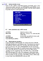
The intensity function is available either in the main page (LIGHT) or
under SETTINGS (BRG). With the RIGHT key, select OFF, LOW, MED or
HIGH illumination.Press COLOR to select any of the 5 color
combinations. Select the color combination and intensity best suited
for viewing conditions and ambient light.

4.6 Back light / Map colors

21

Summary of Contents for FMS50MM

Page 1: ...FMS50MM EFIS ver 4 10 uk 16 01 2002 EFIS Instrumentation FMS50MM FMSAT ...

Page 2: ...ase dealer s name and model and production number of the product The Digifly guaranteemaynotapplyif the documents have been altered in any way or made illegible repairs or product modifications and alterations have been executed by unauthorised service organisations or persons damage is caused by accidents including but not limited to lightning water or fire misuse or neglect In case your Digifly ...

Page 3: ...bration notes Pag 8 2 1 2 Calib of magnetic field and acceleration sensors Pag 9 2 2 Autoconfiguration of sensor modules Pag 9 Pag 10 4 1 Moving Map screen Pag 11 4 1 1 Navigation data Pag 11 4 1 2 Cartogrphic section Pag 12 4 1 3 Navigation system Pag 13 4 2 Keyboard Pag 13 4 2 1 Basic functions Pag 13 4 3 Menues Pag 14 4 3 1 Waypoint Pag 14 4 3 2 Save Fix Pag 15 4 3 3 Routes Pag 16 4 3 4 Setting...

Page 4: ...s available only in EFIS Pag 29 5 8 Flight altitude recording Pag 29 5 9 Instrument simulator Pag 30 NOTES about EFIS module Pag 31 32 6 1 Software upgrades Pag 33 6 2 Upgrade procedures Pag 34 6 2 1 Check List customization Pag 35 6 3 Terminal Pag 37 6 4 Barometer calibration Pag 37 6 5 Anemometer Slope calibration Pag 37 6 6 Zero anemometer Pag 37 NOTES about Maintenance Pag 38 39 7 1 FMS50 Gene...

Page 5: ...which depend on the different modules let you able toobtaindifferent functions Moving MapGPSor Moving Map GPS EFIS 4 Necessary modules for the full functions GPS Moving MAp Efis Necessary modules for the full functions GPS Moving MAp Moving Map Gps Efis Moving Map Gps ...

Page 6: ...ck of the panel to download future software upgrades For panel installation use the specifically provided bolt on the bottom plate of the instrument Do not use or change any of the screws of the instrument Allow clear air flow through the air ducts o the instrument sides Position the GPS antenna away from sources of electromagnetic interference Radio transmitters strobo transponder et with a clear...

Page 7: ...existing lines Avoid water entering through the tubing into the instrument The Red positive and Black negative wires out of the female plug to fms50 provided in the installation kit should be connected to the same electrical supply of FMS50MM to switch on simultaneously both units Allow easy accessibility since the same cable is used for downloading to FMS50MM of the software upgrades The system w...

Page 8: ... RCA PLUG RX GPS NMEA TX AUTOPILOT NMEA GND YELLOW ORANGE RED BLACK 12V max 150 mA LED Warning 470Ω W 470Ω W LED Alarm GPS I O 1 2 3 5 4 6 1 2 3 4 6 5 7 POWER 4A 1 3 Electrical Schemes fms50 back view Following this indications during the mounting you will ensure a proper usage of your Digilfy instrumentation ...

Page 9: ...ther instruments are added in the vicinity of the fmsAT or if the unit is installed into another instrument panel Position the airplane on a leveled surface away from a metal mass or buildings Pressing key accelerometers will store the position as 0 pitch and 0 skid with Z axis set to 1 G Scroll with key to CALIB_LOCAL_X and press key twice With keys enter a compensation so that the value under FI...

Page 10: ...ly sets configuration parameters One of the two serial ports is connected to the GPS sensor the AUX port can be either connected to the Lap Link cable to a PC for software download or to the fms50 automatically enabling EFIS display When the internal module for engine data is installed a additional engine flight data pages are enabled It is possible to select whether the internal module or fmsAT i...

Page 11: ...e and then power up FMS50 with connected modules fmsAT To switch off select the main MENU page and select the function POWER OFF The message WAIT FEW SECONDS will appear followed by SWITCH OFF THE UNIT FmsAT does not need a switch on switch off sequence 10 ...

Page 12: ...n Name of destination if active Time to destination Distance to Destination Ground Speed Analog Direction Indicator Arrow pointing straight up means on track Numeric Direction Indicator Autopilot ON top left position Lat Long See also section 4 4 Dead Reckoning Bottom section Middle section Top section TO TTG DST GS ADF BRG A 1 4 5 7 8 9 6 2 3 11 ...

Page 13: ...dow will present relevant information taken from Jeppesen data base If additional information is present press when finished press to leave Control areas are presented by intermittent lines _ _ _ _ _ F_ _ _ _ _ FIR _ _ _ _ _ T_ _ _ _ _ TMA _ _ _ _ _ C_ _ _ _ _ CTR _ _ _ _ _ A_ _ _ _ _ ATZ Restricted areas are delimited by dotted lines R Obligatory VFR routes are presented as continuous lines with ...

Page 14: ...he different screens its actual function will be shown near the key ZOOM Higher resolution on Map lower scale ZOOM Lower resolution higher scale FIX DEST Cursor moves to actual position or to selected destination MENU To access to all system functions LIGHT FMS50MM Sets back light intensity MOVE CURSOR Use round Up Down Left Right to mov the cursor INSTRUMENTATION EFIS FMS50MMI Selects Instrumenta...

Page 15: ... screen on off Light or Instrument Altimeter on off Press key to access to main Menu Use keys to select desired function Press the key or Key to activate a function Press the Key to leave or return to previous Menu This function manages a data base with 200 waypoints Keyboard s main functions summary 4 3 1 Waypoint Œ ŒŒ Ž ŽŽ 4 3 The menues MENU UP DOWN ENT RIGHT MENU 14 ...

Page 16: ...oint with keys then press a confirm message will appear press once more to confirm MENU to abort With a long waypoint list press to move to next page to leave WAYPOINT section press Saves current position in the waypoint data base The name will be automatically assigned and the symbol will be ENTER A NEWWAYPOINT MODIFY WAYPOINT DATA DELETE WAYPOINT ACTIVATE WAYPOINT SCANNING WAYPOINT LIST UP DOWN ...

Page 17: ...int data base The active route is shown on themapbyalineconnectingtheselected data points the direction is shown by changing the symbol of the waypoint to be reached next Enter the Routesmenu Left right key to select the route Down key to enter the mode all keys change definition see further down Activates the route being shown If the Route was already Active this function can be used to now deact...

Page 18: ...so available REMOVE key The waypoint is removed from the route not deleted from the data base CHANGE key The selected waypoint can be exchanged with another one selected from the data base MENU key Returns to route selection Two modes are foreseen 1 After selection of ROUTES menu select with LEFT RIGHT keys the route to be activated then press ACT The message ACTIVE will appear on the screen and t...

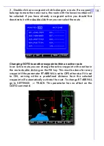
Page 19: ...route you can change the active waypoint with another in the route on the FIX key This must be done for every waypoint if the parameter RT ARRIVAL is set to OFF otherwise if it is set to ON arriving within a predefined distance from the selected waypoint will automatically activate the next To change RT ARRIVAL go to SETTINGS TRACK This parameter has no effect on the GOTO command double click doub...

Page 20: ...deleted and press CLEAR Enter in the ROUTES menu select the Route to be reversed and press REV The following items can be selected or disabled on the displayed map HIGH Highways ROADS Main roads and secondary highways RAIL POWER Power lines RIVER BUILT City boundaries TRACK Small roads NAMES Names of villages mountains etc AIRP Airports VOR NDB INTER Intersections CONTR Controlled Areas RESTR Rest...

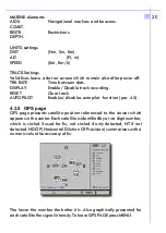
Page 21: ...ILOT Enables disables autopilot function par 4 5 GPS page presents satellite position referenced to the viewer which appears in the center Each satellite is identified by a two digit number which is circled if used for fix not circled if only detected NT if not detected HDOP Horizontal Dilution Of Precision summarizes with a numeric value the accuracy of fix The lower the number the better it is A...

Page 22: ...will be frozen until valid fixes will be received again With Autopilot ON NMEA 0183 format data for route correction and following is sent on pin 2 of the 6 pin GPS connector If an Autopilot is connected the aircraft will be automatically directed to the Active waypoint Whenthisfunction is enabled the letter A is presented in the top left section of the screen The intensity function is available e...

Page 23: ...22 NOTES ...

Page 24: ...23 NOTES ...

Page 25: ...24 NOTES ...

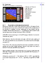
Page 26: ...eto resistive sensors the 3 components of gravity force as well as absolute barometric pressure and differential air pressure are also detected Integration of fmsAT data with GPS simultaneously acquired by FMS50 is used to correct for Pitch angle when increasing or decreasing speed and for Roll angle when turning and to provide Rate of Turn There are a number of advantages when compared to mechani...

Page 27: ... is between 300 to 1200mB ADF GPS Same meaning as in the GPS page direction to move to selected way point Skid indicator Intuitive indication of angle with full scale reading of 10 if the small ball moves outside the two central lines the skid angle exceeds 2 5 Time of turn The minutes and tenths of minutes needed for a full turn appear on the side of skid indicator Shown only when turn time is be...

Page 28: ... 00 G 0 01 G On the default page fmsAT shows Indicated Air Speed IAS Km h Altimeter QFE ALTI m Rate of Climb VARIO m s SKID Magnetic heading COMPASS PITCH In the EFIS page the meaning of keys is shown by pressing the button on the right of the direction buttons The PAGE displays engine data if the Engine Module is present The PRESS key selects among QFE QNE and QNH and allows editing of pressure v...

Page 29: ...nactivity the field will return black To zero QFE display on fmsAT press for at least 3 seconds the down arrow QFE zero on fmsAT does not reset the EFIS display To set at desired values QFE QNH after selection increase or decrease the value with the UP or Down key of the group of 4 then push again PRESS 5 5 Altimeters adjustment EFIS 5 5 1 Zero QFE 5 5 2 QFE QNH Adjustment ...

Page 30: ...t UNITS pressMENU A time recording of altitude data are stored internally in FMS50 QNH data Barometric not GPS are used This data can be viewed immediately without need of PC The time interval between data points can be set in the menu INSTRUMENTS with the parameter REC RATE sec The number of available data pionts is about 2000 thus with a REC RATE of 10 seconds over 5 hour flight can be recorded ...

Page 31: ...eys point to the beginning or to the end of the recording UNITS changes from meters to feet Only one flight recording is supported All instrument functions in EFIS can be simulated without connecting to the fmsAT sensor module To start simulation from MOVING MAP select MENU then SETTINGS and DEMO INSTRUMENTATION with direction keys 5 9 Instrument simulator ...

Page 32: ...31 NOTES NOTES ...

Page 33: ...32 NOTES ...

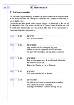
Page 34: ...fferent releases below You will decide then if it is convenient to you installing the new version 2 01 26 1 99 First official release 3 01 30 6 2000 Map colors can be changed by user Software can be upgraded via Cartridge Version MMI includes barographic recorder 3 02 4 8 2000 Routes management check list and altimeter barometric included Bugfix for Cursor in New Guinea 4 07 4 9 2001 EFIS instrume...

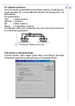
Page 35: ...racteristics CPU 386 or Pentium Mb RAM 2 Mbmin OS DOS Windows Floppy integrated or external Null Modem cable also named Lap Link shows internal connections as in the following diagram Use the function which copies system files on the Floppy Normally included among the Formatting functions See example below 2 TXD RXD GND 3 5 2 3 5 Dsub 9 poles female Dsub 9 poles female Connecting NULL MODEM o Lap ...

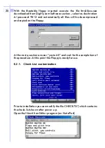
Page 36: ...l files will be decompressed and copied on the Floppy At the next question answer yes to All and wait for the completion of the procedure At this point the Floppy is ready for use Prior to installation you canmodify the file CHECK TXT which contains the check list shown after power up Open the file with an Editor program ex Note Pad 6 2 1 Check List customization 35 ...

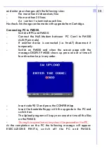
Page 37: ...onnected i e fmsAT disconnect it temporarily Switch on FMS50 and when the screen page with the message DIGIFLY FMS50 shows up press one at a time all four direction keys in any order Insert code 9012 and press the CONFIRM key Insert the bootable floppy with the upgrade in the PC and switch it on The Upload program will copy now one at a time all the files on the FMS50 At the completion on the PC t...

Page 38: ...the final test and should not be modified unless there are at least 6 mB difference 50 m from a reference Altimeter Barometer located in the immediate vicinity of the fmsAT Enter in the set up mode with the following key sequence Select BAR_S and press The value set at the Factory is around 0 00900 modify the value with Increasing by 0 000001 the barometer reading is reduced by 1 mB and the altitu...

Page 39: ...38 NOTES ...

Page 40: ...39 NOTES ...

Page 41: ... DCE type plug for dditional devices connection or software upgrade Power requirements 11 15 VDC 1 A Weight 1 5 Kg Dimensions 159 mm 6 25 W 108 mm H 100 mm D Operating temperature range 20 C to 70 C Data base Jeppesen aeronautic with detailed airport description radio assistances and controlled areas Electronic CMAP cartography 200 user waypoint 10 routes each of 10 waypoints 2000 points for path ...

Page 42: ...digital indication in min and 1 10 min Attitude indication for Pitch and Roll Precision 1 between 60 to 60 Sliding rule Compass with 1 precision at airplane constant speed G meter with 3 G full scale and 0 01 G resolution Display LCD 2x16 chars back illuminated high contrast Interface Serial connection RS232 9600 baud 9 pinmale connector Protocol ProprietaryDigifly Europe Electrical supply 10 18 V...

Page 43: ...8 Mechanical features FMS50 fmsAT 25 mm 100 mm 83 mm 4MA screw for back mounting 42 77 mm Dynamic Power and Communication Static GPS Power ...

Page 44: ...on EFIS Magnet Compass Own position Cursor position One click Map or Instrum Two click Fix coordinates or Altimeter One click Menu Two clik Full screen mode One click Fix or Dest Two click Make Mark and Goto One click Zoom out Two click Info Area One click Zoom in Two click Info Airp Airport Contr Areas Time to destination Distance to destination Active goto name FIX Coord Moving map Skid indicato...

Reviews: