Copyright © 2022 DJI All Rights Reserved.
11
connected to the internet through WiFi or the 4G dongle). If the Ntrip service is connected and the
RTK status is FIX throughout the flight, the base station file will be automatically saved in the results
file.
3.1.2 D-RTK 2 Base Station Solution
Set up D-RTK 2 at a known point. Switch the D-RTK 2 to Mode 5. In the RTK settings page of the DJI
Pilot App, select D-RTK 2 as RTK Service Type. Then link the aircraft to the D-RTK 2. In the RTK
settings page, go to the Advanced Settings (Pin: 123456 by default). Modify the D-RTK 2's
coordinates to the coordinates of the known point.
When high absolute accuracy is needed, you must set up the D-RTK 2 at a known point instead of
directly using its self-convergent GNSS coordinates. This is because the static convergent coordinates
of the D-RTK 2 have an error in the meter-level. If the D-RTK 2 position is not corrected with known
coordinates, the absolute accuracy of the result cannot be guaranteed and the point cloud data from
multiple flights might not be consistent.
Note when setting up the D-RTK2 at a known point it is important to add the rod height. When post
processing, the default output will be WGS84 unless otherwise selected.
After setting up the D-RTK 2 base station, you can connect the aircraft to the D-RTK 2 for the flight
mission.
Alternatively, you can use the PPK method where no real-time connection between the drone and the
D-RTK 2 is required. With the PPK method, the distance between the D-RTK 2 and the aircraft is
recommended to be within 10km. Select "None" in the RTK service type. Turn off the RTK Positioning
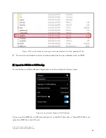
switch to go to GNSS flight mode. After data collection for the mission is completed, use a Type C
cable to connect the D-RTK 2 to a PC. Copy the base station file with a suffix of .DAT for the
corresponding time slot and paste the file in the same folder as L1’s result file. In this way, DJI Terra
will use the D-RTK 2 data for PPK processing to calculate the accurate POS data.
3.1.3 Third-party RTK Solution
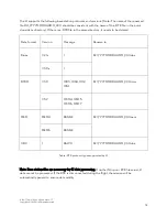
A third-party RTK base station device can also be used for PPK. In this case, no connection is required
between the drone and the RTK base station. The distance between the third-party RTK base and the
aircraft is recommended to be within 10km. After the flight is completed, search for the base station
file for the corresponding time slot and rename the file following the suffix rules below. Then, copy
the base station file to the same directory as the LiDAR files. If the third-party RTK base station has no
coordinates input for the known point, you can open the .O base station file in text form and modify
the "APPPO POSITION XYZ" value to be the corrected coordinate of the RTK base in the ECEF
coordinate system.


