Ignis Operations Manual (DJI M600 Variant)
Drone Amplified
7.5.3 Elevation Data
The elevation maps used in this app are from the Shuttle Radar Topography Mission
(SRTM), which collected elevation data of the Earth’s surface between 60 degrees north and
56 degrees south latitudes in February of 2000. The data points are posted every 1 arc-second
(approximately 30 meters), with 1 meter of height resolution. Areas above 50 degrees north
and below 50 degrees south are sampled at a resolution of 2 arc-second by 1 arc-second. Some
map tiles may contain voids. For more information, see https://www.usgs.gov/centers/eros/
science/usgs-eros-archive-digital-elevation-shuttle-radar-topography-mission-srtm-1-arc
Additional data sets may be incorporated in the future.
7.6 Map Overlays
PDF files with georeferenced maps (such as those created by Esri ArcMap), KMZ files, KML
files, and CSV files with latitude and longitude columns can be displayed as an overlay on
the map while flying.
Figure 52: Map Overlays Screen
Pressing the “MAP OVERLAYS” button on the main menu will open a screen similar
to Figure 52. This screen will display all of the map overlays loaded by the app, but it is
currently empty in this figure.
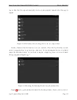
If you’ve download some georeferenced pdf, kmz, kml, or csv files onto your mobile device,
then you can load them by pressing the “ADD OVERLAY FILE” button. This opens a file
browser so you can navigate to the file on your device, as shown in Figure 53. The flight
Last Updated March 12, 2020
Page 71


