Ignis Operations Manual (DJI M600 Variant)
Drone Amplified
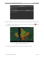
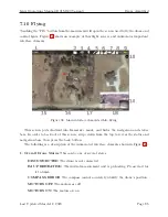
10. Compass
Shows which direction North is on the map. Touch this to rotate the map
so that North is up.
11. Home Location
This is the location that distance is measured relative to, and where
the Drone will fly to if the Go Home procedure is initiated.
12. Drone Location and Attitude
This marks the location and orientation of the drone.
The icon will also pitch and roll to reflect the attitude of the drone. Touching this will
center the drone in the screen and enter a mode where the map will move and rotate
to follow the drone. Drag the map to break out of this mode.
13. Map Scale
Shows the scale of the map.
14. Live Video Feed
This displays the video being streamed from a camera connected to
the drone. Touching this will maximize it. Touching this while it is maximized will
return it to normal size.
15. Drone Horizontal Speed
Displays the horizontal component of the speed of the drone.
16. Drone Vertical Speed
Displays the vertical component of the velocity of the drone.
17. Horizontal Distance between Drone and Home
Displays the horizontal compo-
nent of the distance between the drone and the home point.
18. Altitude of Drone
Displays the altitude of the drone above the takeoff location. If
the app has elevation maps for this area, then it will also display the altitude above
ground level in parenthesis.
You can zoom, rotate, and translate the map using touch gestures. When the map is
rotated, a compass will appear in the top right corner. Touch the compass to reorient the
map so that north is up.
Last Updated March 12, 2020
Page 88

