

SV-MAP-270 Navigation Mapping Software
SkyView Pilot’s User Guide - Revision M
7-43
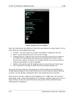
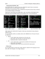
Editing and Deleting Waypoints
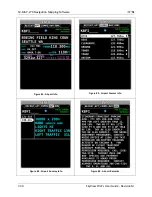
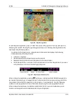
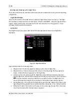
Select MAIN MENU > MAP > MENU > EDIT USER WAYPOINTS to view a list of all current user
waypoints. To modify or delete a waypoint, highlight the waypoint of interest and press EDIT or
DELETE.
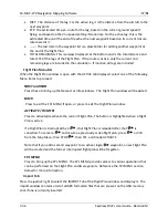
Waypoint Menu
The WPT MENU button under MAIN MENU > MAP > MENU > EDIT USER WAYPOINTS contains
the following additional user waypoint options:
Export Waypoints – Exports all user waypoints to a CSV (comma separated values) file
on a USB memory stick. A USB memory stick must be connected to the display that you
perform this operation from.
Import Waypoints – Imports user waypoints into the display from a properly-formatted
CSV (comma separated values) file on a USB memory stick. A USB memory stick must be
connected to the display that you perform this operation from. Imported waypoints are
added to any existing user waypoints that are in the SkyView system. If your SkyView
displays are connected via Ethernet in addition to SkyView network, the user waypoints
database will be distributed and synchronized between all displays. If your displays are
not connected via Ethernet, you will need to import this file on each display separately.
See the SkyView Installation Guide for more details about this connection.
Clear Database – Deletes all user waypoints currently stored in SkyView.
User Waypoints CSV (comma separated values) File Format
An easy way to obtain a valid CSV file to edit is to simply create a user waypoint using your
SkyView display and then export it. You can then edit it to add additional waypoints using a text
editor. You can also use a spreadsheet program such as Excel to edit the file. If you use a
spreadsheet, make sure that you save the file in the CSV format and not in a proprietary
spreadsheet format.
The CSV file format used to store user waypoints contains one waypoint per line. Each waypoint
(line) is separated into fields by commas in the following manner:
Short Name,Long Name,Latitude,Longitude,Altitude,Icon,Narrative Text
Valid data for the fields are:
Short Name (Identifier)
o
Up to 8 characters, A-Z, 0-9, all upper case
Long Name (Name)
o
Up to 22 characters, A-Z, 0-9, all upper case
Latitude
o
Decimal format. Example: 47.770840
Longitude
o
Decimal format: Example: ,-122.151749