background image


27


Constellation


Constellation refers to the specific set of orbiting GPS satellites system, used in 
calculating positions or all the satellites visible to a GPS receiver at one time. The 
pattern created by the relative positioning of a GPS satellite network is designed to 
achieve a very high probability of global satellite coverage even in the event of 
satellite outages. 
 

dB 

Decibel. A notation of relative unit such as the satellite signal strength received. 
 

DATUM 


A math model which depicts a part of the surface of the earth. Latitude and longitude 
lines on a paper map are referenced to a specific map datum. The map datum selected 
on a GPS receiver needs to match the datum listed on the corresponding paper map in 
order for the position readings to match. 
 

Elevation mask


Elevation mask is an adjustable feature of GPS receivers that specifies a satellite must 
be a certain number of degrees above the horizon before its signals are used for 
positioning. Satellites at low elevation angles (five degrees or less) have lower signal 
strengths and are more prone to loss of lock thus causing noisy solutions. 
 

Ellipsoid


A geometric surface which all of whose plane sections are either ellipses or circles. 
 

Ephemeris


Ephemeris is a set of parameters used by a global navigation satellite receiver to 
predict the location of a satellite and its clock behavior. Each satellite contains and 
transmits ephemeris data about its own orbit and clock. Ephemeris data is more 
accurate than the almanac data but is applicable over a short time frame from four to 
six hours. Ephemeris data is transmitted by the satellite every 30 seconds. 
The predictions of current satellite position are transmitted to the user in the data 
message. 
 

Geodetic coordinate 

A coordinate system whose elements are latitude, longitude and geodetic height. The 
latitude is an angle based on the perpendicular to the ellipsoid. Longitude is the angle 
measured in the XY plane. 
 

Summary of Contents for Crux II

Page 1: ...CRUX II GPSJAQ GPS Receiver User Guide EMTAC ...

Page 2: ...e and map photos are belonged to respective owners EMTAC reserves the right to make changes and improvements to any of the products described in this document without prior notice Under no circumstances shall EMTAC be responsible for any loss of data or income or any special incidental consequential or indirect damages howsoever caused Remark The synthetic screen displays on the PDA in this manual...

Page 3: ...s assist tool but does not substitute the needs of careful steering and good judgment Never only rely on one single tool or apparatus for positioning and navigation Accessories There may have accessory supplied with the CRUX II GPSJAQ receiver which are specifically designed for the CRUX II GPSJAQ Use of other accessories will severely degrade performance or even damage the receiver and will void ...

Page 4: ...y the Warnings Disclaimer and Limitation of Liability Basic Guidelines Care and Maintenance and the whole User Guide Remarks 1 The External Active Antenna is an optional accessory which not included in the package 2 The Charger is an optional accessory which not included in the package ...

Page 5: ...mstances shall EMTAC and its subsidiaries are responsible for any loss of data or income or any special incidental consequential or indirect damages howsoever caused The contents of this User Guide are provided as it Except as required by applicable laws no warranties of any kind either express or implied including but not limited to the implied warranties of merchantability and fitness for a part...

Page 6: ...tenna 14 External antenna port 15 CF slot 15 Power jack 16 External active antenna Optional Accessory 16 3 Operation Guide 17 Step 1 To install the GPS MAP application software in the iPAQ 18 Step 2 To operate the GPS MAP application software 19 Step 3 To connect with the external active antenna optional 20 Use of the power jack 21 Connect with external active antenna 22 4 Troubleshooting 24 5 Car...

Page 7: ...sult the instructions of the iPAQTM Pocket PC and the GPS application software The CRUX II GPSJAQ is designed for the iPAQ Pocket PC use DO NOT TRY TO FIT OR TO CONNECT THE CRUX II GPSJAQ WITH OTHER TYPE OF PDA or OTHER HOST DEVICE INTERFERENCE GPS receivers may receive interference near cellular base station and when in close proximity to mobile phone antennae This interference may affect positio...

Page 8: ...ns Switch off the host platform and discontinue operation of the CRUX II GPSJAQ receiver in hospital ICU aircraft gasoline station near fuel or chemical near blasting area or other restricted areas NOTICE Read the Warnings section comprehensively before operation Remarks 1 The External Active Antenna is an optional accessory which not included in the package 2 The Charger is an optional accessory ...

Page 9: ...cluding Navigation and Positioning Find Street and Route Travel Route Planning Recreation Safety and Security Fleet Management Logistic Field Force Management Location Based Service LBS Figure 1 The synthetic screen displays on the PDA in this manual and on the package description are for demonstration purpose only All the trade names and all the map software are belonged to their respective owner...

Page 10: ...t the Earth at an altitude of approximately 17 500 kilometers and ground control stations Each of the 24 satellites deployed in 6 orbital planes circles the earth twice a day The system satellites continuously transmit signals contain the information of time and distance in a precise formation 24 hours a day in any weather condition everywhere around the world By processing the signals received GP...

Page 11: ...n the receiver to latitude and longitude coordinates which is usually provided in the geodetic datum on which GPS is based WGS 84 Position offsets of hundreds of meters or much more can result from using the wrong datum In addition to datum used there are number of positioning errors can occur limiting accuracy The major errors including satellites orbiting error poor satellites geometry multi pat...

Page 12: ...s Built in power jack no adapters required for newer iPAQ Pocket PC Optional external active antenna for in vehicle and indoors usage Outstanding performance even along tree lined streets urban canyons and in vehicles with coated windshields Allows mounting the iPAQ Pocket PC anywhere you like in the vehicle In the following sections each portion of the GPSJAQ are described see Figure 2 which illu...

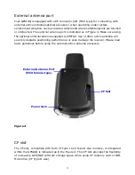
Page 13: ...13 front view rear view A Embedded Active Antenna B CF slot C External Antenna Port D Power Jack Figure 2 A B D C A ...

Page 14: ...area is indicated in Figure 3 Keep this facade area surface clean and clear view to the sky while operating the GPSJAQ Do not let this frontage surface area covered fully or partially by any object especially contains metal and or electromagnetic wave absorption materials such as screwdriver pen watch floppy diskette CD and metal wires thin metal foil like aluminum foil and metal coated plastic ba...

Page 15: ...ternal antenna supplied by EMTAC Use of other active antenna will severely degrade positioning performance or even damage the receiver Please read basic guidelines before using the external active antenna accessory Figure 4 CF slot The CF slot compatible with both CF Type I and Type II size memory is integrated within the GPSJAQ is indicated as in the Figure 4 This CF slot provides the flexibility...

Page 16: ...essory Connecting the optional external active antenna to the external antenna port described in previous section External Antenna Port as indicated in Figure 4 This optional active antenna is embedded magnet in the bottom for easy mounting on metal surface be caution not put near to materials are sensitive to magnetic field such as magnetic storage media like floppy diskette Figure 5 is the refer...

Page 17: ...not For information about the operation of the iPAQ Pocket PC and the GPS MAP application software installation procedures please refer to the documentation that accompanies each product respectively In this Chapter a step by step operation procedure is described Step 1 To install the GPS MAP application software Step 2 To connect with the iPAQ Pocket PC Step 3 To operate the GPS MAP application s...

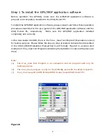
Page 18: ... installed completely and correctly In the User Guide CD ROM there is the Crux_View Test Program Evaluation version for testing purpose Please follow the step by step procedure indicated and described in the CRUX_VIEW Evaluation Manual file in pdf format Figure 6 is a screen shot example of Crux_View Test Program indicating the Satellites in view and Signal Level View Note a The Crux_View Test Pro...

Page 19: ... with the iPAQ Pocket PC simply slide the iPAQ Pocket into the GPSJAQ and connected Figure 7 illustrates the GPSJAQ is well fitted and connected with the iPAQ Pocket PC Please also consult the operation procedures described in the user guide of the iPAQ Pocket Figure 7 ...

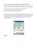
Page 20: ...the iPAQ Pocket Open the GPS MAP application in the iPAQ Pocket PC Enter into the GPS Map application operation Consult and follow the details operation guidance described in the user guide of the GPS MAP application software which you installed Figure 8 illustrates the Crux_View Test Program is well in operation the screen display is example of the Satellites in view and Signal Level View which i...

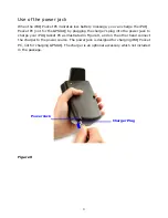
Page 21: ...ng the charger s plug into the power jack to charge your iPAQ Jacket PC as illustrated in Figure 9 and on the other hand connect the charger to the power source The power jack is designed for charging iPAQ Pocket PC not for charging GPSJAQ The charger is an optional accessory which not included in the package Figure 9 Power Jack Charger Plug ...

Page 22: ...board where are not affect driving safety and appropriated Use only the active antenna optional accessory supplied with the BTGPS Use of other antenna will severely degrade positioning performance or even damage the receiver Read Basic Guidelines before using external active antenna accessory Figure 10 The external active antenna is an optional accessory which not included in the package Connect a...

Page 23: ...dded magnet in its bottom for easy mounting on metal surface be caution not put near to materials are sensitive to magnetic field such as magnetic storage media like floppy diskette and mechanical wrist watch ...

Page 24: ...not always over the same point on the Earth The constellation of the GPS satellites is not geostationary Based on satellite variation from to time you could experience a position fix faster some times Buildings obstruct any GPS signal so setting up in a vertical window immediately blocks at least half of the sky view 3 Why I can t open the MAP GPS application in the iPAQ Pocket PC Check the MAP GP...

Page 25: ...etergents Do not drop shake or knock the GPSJAQ Rough handling can break the connector jack switch and internal electronic circuit boards Dropping the GPSJAQ may break the connector jack and switch which will cause non recoverable and malfunction damages Do not expose to rain or high humidity environment or even pour water on it which will cause malfunction or non recoverable damage Do not sore GP...

Page 26: ...lso referred to as a baud rate Channel Channel refers to a set of hardware in the receiver that detects locks on and continuously tracks the signal from a single GPS satellite The more channels available the greater number of GPS satellite s signals a receiver can simultaneously lock and track A receiver of 12 channels is the optimized design considering the current consumption chip package size a...

Page 27: ...be a certain number of degrees above the horizon before its signals are used for positioning Satellites at low elevation angles five degrees or less have lower signal strengths and are more prone to loss of lock thus causing noisy solutions Ellipsoid A geometric surface which all of whose plane sections are either ellipses or circles Ephemeris Ephemeris is a set of parameters used by a global navi...

Page 28: ...orth and south poles Multipath Multipath is the reception of a signal both along a direct path and along one or more reflected paths Multipath signals result in an incorrect pseudorange measurement NMEA NATIONAL MARINE ELECTRONICS ASSOCIATION A U S standards committee that defines data message structure contents and protocols to allow the GPS receiver to communicate with other pieces of electronic...

Page 29: ...sly has resulted in an offset between GPS time and UTC After accounting for leap seconds and using adjustments contained in the navigation message GPS time can be related to UTC within 20 nanoseconds or better Greenwich Mean Time GMT is still the standard time zone for the prime meridian zero longitude Warm Start Start mode of the GPS receiver when current position clock offset and approximate GPA...

Page 30: ...30 gravity field model GPS satellite orbital information in the navigation message is referenced to WGS 84 ...

Reviews: