background image

6.6.Find Friends

Use this function to find your friends, for instance when skiing or skating. If you activate Live 
Tracking, you can even have you friends' coordinates refreshed regularly. You friends' 
positions are also displayed on the map. You can use the Navigator to have yourself 
navigated to a friend whose position is dynamically refreshed. 

The list of friends relevant for this function is created in the GPS-Sport.net portal (would be 
too complicated from 

Run.GPS

). Sign in at 

www.GPS-Sport.net

 and browse your Athlete's 

Homepage. Then click 

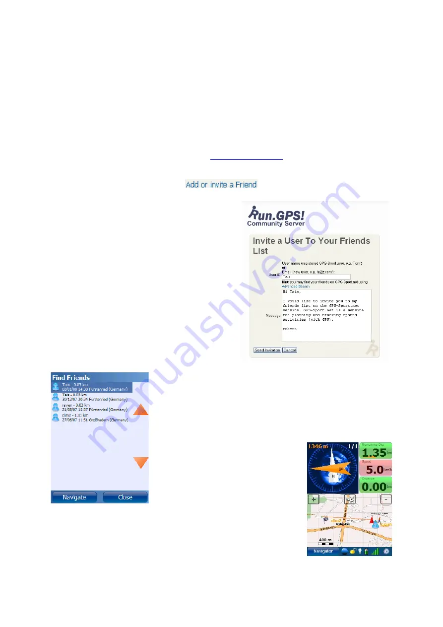
You'll get the opportunity to send a short 
message to your friend:

The friend will receive an email and must accept 
your request with a click.

Once this is done, you can always access your 
friends' positions online:

Both the names of your friends and the distance to them is 
shown in the list. There is also the date and time your friend's 
last position update.

Click on an entry to navigate to a friend.

100

Summary of Contents for Run.GPS UV

Page 1: ...Manual for Run GPS Trainer UV and Run GPS Trainer UV Pro Version 2 4 1 August 1st 2012 1...

Page 2: ...with External GPS Device 21 3 6 Testing a Bluetooth Connection with SerialTester 23 4 Functions and Features 25 4 1 Control Bar 25 4 2 Main Menu 26 4 3 Main Screens 28 4 3 1 Recorder 28 4 3 2 Navigat...

Page 3: ...ctivating the OpenStreetMap layer in Run GPS 78 5 1 3 Loading Maps Prior to a Planned Tour 78 5 1 4 Contribute to the OpenStreetMap using Run GPS 79 5 1 5 Cycle Map and OpenPisteMap 80 5 1 6 Adding Mo...

Page 4: ...eens 109 7 4 File System 110 7 4 1 The Run GPS Data Directory 110 7 4 2 Moving the Data Directory to the Storage Card Windows Mobile 111 7 5 Security Issues 113 7 6 Technical Data 114 7 7 Conserving B...

Page 5: ...stream Inc CND The geonames org service www geonames org is licensed under Creative Commons Attribution 3 0 licence see http creativecommons org licenses by 3 0 OpenStreetMap www openstreetmap org Cyc...

Page 6: ...rmation also via voice output through your earphones Recording tracks Analysis of training sessions continuous calorie calculation Creating speed and altitude diagrams Importing and displaying raster...

Page 7: ...bling the athlete to monitor his or her improvements in performance 1 2 3 Marathon The committed sportsman obtains the track data for the competition some weeks before the actual competition Thus he c...

Page 8: ...nes 1 2 6 Bike Tour The entire tour is planned with Run GPS Route Planner Places of interest are marked with placemarks On the tour navigation is the most used Run GPS feature Sights photographed on t...

Page 9: ...interesting tours for inline skaters worldwide Run GPS is the best tool to follow these tours in a convenient fashion 1 2 9 Canoeing Run GPS leads the canoeist on the best path to the correct exit pl...

Page 10: ...ne In the following only the EXE installers are described On Windows Mobile 6 or greater the Net Compact Framework is already pre installed and therefore the installer version without the Net Compact...

Page 11: ...3 You ll get access to trial and full versions Installation via download from www rungps net 1 Install an application manager like Astro you can get it for free from Android Market 2 Download the Run...

Page 12: ...utside and maybe put your device to the ground to avoid movement in an open spot to ensure optimal reception wait until the signal quality display says good 4 Close the GPS status dialog and push the...

Page 13: ...iner UV and Run GPS Trainer UV Pro are characterized by the following feature matrix Feature Run GPS Lite Run GPS Trainer UV Run GPS Trainer UV Pro Trainings recording Training upload Voice output Liv...

Page 14: ...eport Exporting training recordings as GPX KML or CSV Exporting placemarks as KML or GPX Fifteen user configurable screens The Windows Phone 7 release of Run GPS Trainer is a mixture of the Pro and no...

Page 15: ...ayPal through PayPal it s also possible to pay be credit card 3 Activate by entering the Run GPS ID see right 4 You ll receive your licence code and invoice via email In our web shop http www rungps n...

Page 16: ...uration Ideal configuration managed by Windows Mobile selecting a COM port not required Smoothing Buffer originally GPS devices provide very inaccurate speed information especially when the speed is l...

Page 17: ...iguration using serial COM port COM port and baud rate can be entered manually or detected automatically Automatic detection does not work in all cases if it doesn t you should search the web or other...

Page 18: ...The GPS device can be connected or disconnected trough this dialog Disconnecting the GPS can be wise for instance when taking a rest because the GPS consumes really much battery power 3 3 GPS Setup o...

Page 19: ...ilt in GPS with the difference that the Bluetooth connection has to be established first First of all switch on Bluetooth on your Pocket PC Then search for Bluetooth devices Connect to the Bluetooth G...

Page 20: ...Assign a COM port number which one does not matter Enter the COM port number in Run GPS You may also try out different baud rate settings 20...

Page 21: ...since some steps have to be performed for getting the GPS connected The functions are pretty well hidden in Windows Mobile for Smartphones On your Smartphone open the settings menu and then select Con...

Page 22: ...After entering a PIN code the GPS device appears in the list of connected devices Select COM Ports in the menu Create a new outgoing port Assign any COM port number 22...

Page 23: ...02002 931 V 0000 0000 N 00000 0000 E 270102 19 GPRMC 002003 931 V 0000 0000 N 00000 0000 E 270102 18 SerialTester is a very simple program that scans all the data coming in on a COM port It can be use...

Page 24: ...SerialTester on a Smartphone All recorded codes are stored for verification in file rungpstest log on the top file system level on your device 24...

Page 25: ...bar It contains the following elements from left to right 1 Main screen choice 2 Starting stopping a training session 3 Show and change currently active sport 4 Keep backlight turned on 5 Lock unlock...

Page 26: ...avigator is being defined Voice Output set the voice output frequency and define which announcements shall be made through voice output Online Services access online services such as Live Tracking and...

Page 27: ...ence shows a document with all keyboard shortcuts and configurable display values About shows the installed program version and holds function for entering licence keys Quit Application shut down the...

Page 28: ...ched using this menu 4 3 1 Recorder This screen is intended for use during a training or competition It contains extra big buttons which can be operated with a finger Start Stop Start or stop training...

Page 29: ...the distance from the navigation route is displayed In the top right corner of the compass display the current position on the route is displayed e g track point 1 of 20 Below the compass navigation i...

Page 30: ...description and a list of possible actions for that item By pressing the configuration button you will get to the map configuration menu Full Route show full covered track plus full navigation route...

Page 31: ...the orange arrows All displays can be changed by holding a button for about 2 seconds 4 3 5 Diagram On the diagram screen you ll find the diagram plus two configurable info displays The values for bot...

Page 32: ...lways scale diagram so the range of values on the y axis is as big as possible 4 3 6 Additional Screens Besides the already mentioned ones there is one additional screen in Run GPS Trainer UV and five...

Page 33: ...33 Wikipedia Guide always shows the Wikipedia article located closest to you...

Page 34: ...itude Lap Ascent m or ft Accumulated ascent difference in altitude gained in selected lap Altitude Lap Descent m or ft Accumulated descent difference in altitude lost in selected lap Altitude Lap Max...

Page 35: ...eful Altitude Min Ascent Rate m min or ft min Minimum ascent rate in training Altitude Max Ascent Rate m min or ft min Maximum ascent rate in training negative value means descent Cadence Avg Cadence...

Page 36: ...otal mileage using Run GPS also when training session is not started Distance Remaining Dist km or mi Remaining distance to the navigation goal GPS GPS Dilution DOP DOP Dilution of Precision see http...

Page 37: ...utes of the training not configurable Heart Rate Mini Heart Rate Diagram full Mini heart rate diagram showing the entire training not configurable Heart Rate Number of Heart Beats Total number of hear...

Page 38: ...i Map 5km Mini Map with about 5 kilometers diameter focusses on the current position shows only important map elements Map Mini Map full Mini Map showing the full training session focusses on the curr...

Page 39: ...enabled Configuration Map Settings Items on Map Wikipedia Articles automatic download Miscellaneous MortPlayer This is not a music player but a remote control for the MortPlayer MortPlayer is great f...

Page 40: ...eed in selected lap only active time taken into account Speed Lap Avg Speed Total km h or mi h Average speed in selected lap totale time taken into account Speed Lap Max Speed km h or mi h Max speed i...

Page 41: ...d lap Time Remaining Time Remaining estimated time before the navigation goal is reached Time Time of Day Time of day Time Training Time Duration of training session until now Time Virtual Lead The le...

Page 42: ...gitude for a photo With Run GPS geo coding is done through the timestamp of the photos For each point in time of a Run GPS training session the geographic position is well known Therefore it is easy t...

Page 43: ...y can be manually added to the training by putting them into the appropriate training folder My Documents Run GPS users uv user training month training folder e g My Documents Run GPS users uv user tr...

Page 44: ...e below 4 6 1 Adding Manual Trainings Adding manual trainings makes it possible for you to have a complete training diary A typical example is when you re doing triathlon training and you want to ente...

Page 45: ...anned training sessions appear as appointments in Microsoft Outlook If you connect your PDA with your PC the appointments are also synced to Microsoft Outlook Creating a Training Plan Determine when y...

Page 46: ...to be covered Average required speed Intensity 0 100 Minimum heart rate Maximum heart rate Navigation route Hint creating training plans in the GPS Sport net portal is much faster You can easily synch...

Page 47: ...ugh the frequency setting you can define if training information shall be spoken in regular time intervals 30 s 1 min 2 min 3 min 5 min 10 min 20 min 30 min or after completing a certain distance 1 km...

Page 48: ...using the military clock scheme 12 means go straight ahead 9 means turn left 15 means turn right 6 means go back The direction is always relative to your current direction of movement Go 14 Route Navi...

Page 49: ...raining partner only announced if a route with timestamps is loaded Lead 5 seconds behind Lead 1 minute 15 seconds ahead Distance Covered distance Distance 5 3 miles Altitude Current altitude Altitude...

Page 50: ...may NOT be used for car navigation 4 8 1 Bee line Navigation Bee line navigation is the most simple type of navigation It is used if there is no route the ways and streets for an area are not known or...

Page 51: ...a see http www openstreetmap org For the actual calculation of a navigation route the JERUSALEM project is incorporated see http www gps sport net routePlanner jerusalem jsp Using OpenStreetMap maps h...

Page 52: ...ed fastest Calculates the fastest way for cars and other motorized vehicles motorized shortest shortest Calculates the shortest route for cars and other motorized vehicles Hint The quality of routing...

Page 53: ...ed the above settings are mainly intended to reduce the number of recalculations to avoid expensive data traffic 4 8 3 Importing Routes from GPS Sport net This is the recommended approach to create ro...

Page 54: ...If you don t see the individual route points zoom in closer Moving route points Click a route point and hold the mouse button pressed while moving the mouse If you don t see the individual route poin...

Page 55: ...tal Maps www GPS Sport net Community portal for Run GPS users offering about 100 000 tracks for free download www GPSies com Portal with many interesting routes directly accessible from Run GPS Route...

Page 56: ...GPS immediately and without restarting Select Navigation Select Route from the main menu Hint if the route does not seem to get imported in Run GPS this might be because of the character encoding the...

Page 57: ...data Latitude Longitude Title Type Hut Restaurant Clearing Description optional Link to a related article optional 4 9 1 Creating Placemarks Placemarks can be created either directly by entering coord...

Page 58: ...ad Cart You can also upload placemarks created in Run GPS to the GPS Sport net portal How to create placemarks 1 Open GPS Sport net and sign in 2 Click the Route Planner button 3 Switch to placemarks...

Page 59: ...emarks Some of the placemark types stored there geo coded Wikipedia articles cities mountains hotels huts castles hospitals The geonames org service is licensed under Creative Commons Attribution 3 0...

Page 60: ...orm GPX and KMZ Procedure for importing from other programs 1 Create a placemark e g in Google Earth 2 Save it as GPX of KMZ and copy the file to your PDA to the My Documents Run GPS placemarks waypoi...

Page 61: ...f average speed or other parameters The determined lead over the virtual training partner is both displayed on the screen and spoken via voice output A positive value means you re ahead and a negative...

Page 62: ...t portal The only requirement for competing against one of the GPS Sport net users is that you have the GPX track data including timestamps for each track point Using the KML format is not possible si...

Page 63: ...every interval change is announced Configure your interval training by clicking Main Menu Training Settings Interval Training It s possible to add any number of intervals After going through all defi...

Page 64: ...eds etc How does it work Basically you have to define the spot where the start finish line is by setting the navigation target to that position route end point or placemark Whenever you cross the navi...

Page 65: ...ould be set up correctly and you can start the training Whenever you cross your destination target a new lap is started 4 12 2 New Lap When Covering a Defined Distance Another possibility is to start...

Page 66: ...The only requirement for getting altitude profiles for the route lying ahead in Run GPS is to use GPX or KML data containing altitude information You may follow these steps 1 open GPS Sport net and s...

Page 67: ...ebsite Polar HRM files file suffix hrm Oregon Scientific CSV files file suffix csv FRWD Sports Computer TXT file suffix txt Data analysis is very restricted if you add your heart rate data afterwards...

Page 68: ...er Bluetooth for Run GPS Trainer on Windows Mobile 1 Moisten the contact pads of the strap and wear the strap when the straps gets contact to your body it is automatically switched on 68 6 Open the CO...

Page 69: ...Google Android 2 x 1 Moisten the contact pads of the transmitter strap and wear the strap when the transmitter strap gets contact to your body it is automatically switched on 4 14 2 Zephyr HRM and Hx...

Page 70: ...ntact to your body it is automatically switched on 70 2 Activate Bluetooth on your Pocket PC e g by using the Comm Manager depending on what device you own 3 Open the Bluetooth connection settings in...

Page 71: ...Setting up the Zephyr HRM HxM on Google Android 2 x 1 Moisten the contact pads of the HRM belt and wear the belt when the HRM gets contact to your body it is automatically switched on 71...

Page 72: ...nce many Sony Xperia models and HTC Rhyme A list of supported Android devices can be found here www thisisant com pages developer zone android api In Configuration Heart Rate Monitor you can choose fr...

Page 73: ...your pulse watch is compatible with the B100 visit the manufacturer s website www frwd fi FRWD B600 same as B100 but delivered with a HRM belt Hint If you want to use the B100 B600 as heart rate moni...

Page 74: ...our HRM belt belonging to your B600 or pulse watch and wear the belt 2 Switch on the FRWD B100 B600 attach the device at your arm and wait until the heart rate signal is received the red light blinks...

Page 75: ...ip To start the Heart Rate Logger you press the orange button once to turn it off you hold the button for two seconds After the training one connects the data logger to a PC using an USB cable The hea...

Page 76: ...vice and is name hr data dat The file is automatically written as soon as your push the stop button to stop a training recording The text file contains the heart beat timestamp milliseconds in the fir...

Page 77: ...etMap project has the goal of making worldwide map data freely available for everyone The project adapts the Wiki principle as everyone is entitled to join in the creation of maps OpenStreetMap data i...

Page 78: ...the storage card See chapter Filesystem for a guide on how to do this To download OpenStreetMap data en route active the automatic download in the same dialog further below You Smartphone will build u...

Page 79: ...editor Track data has to be revised and assigned to a street section Tracks can be committed to OpenStreetMap in GPX file format There are three ways to do this direct upload browse Training Log Deta...

Page 80: ...see http creativecommons org licenses by sa 2 0 The alternative maps are activated in the map settings option Items on Map Cycle Map Web http www gravitystorm co uk osm Content OpenStreetMap ways with...

Page 81: ...store it on your PC 2 Copy the file to your mobile device to the SD Card My Documents Run GPS directory the name SD Card may vary 3 After restarting Run GPS the added map layers can be selected in the...

Page 82: ...ayer dirName directory in which the map tiles will be stored cache must not contain spaces or special characters copyright copyright information minZoom and maxZoom minimum and maximum zoom for the ma...

Page 83: ...ded to an existing ratlas file while your outdoors Information about the file format and links to the required tools etc can be found here http www rungps net wiki RunGPSAtlasFormat Creating Run GPS A...

Page 84: ...Mobile or to sdcard Run GPS map_images Android on your mobile device After restarting the Run GPS application the new map can be selected from Configuration Map Configuration Items on Map Online Layer...

Page 85: ...o create a track map Using this feature you can build yourself a map of your environment Displaying the Instant Trail Map and adding new tracks to the map can be separately turned on or off Configurat...

Page 86: ...nd the position file to the Run GPS map_images directory jpeg xml raster map image XML position file jpeg kmz raster map image KMZ position file Google Earth Windows Mobile version only jpeg gmi gsi r...

Page 87: ...g in and start Route Planner by clicking on the blue Route Planner button Scroll the map to the spot you want to export You can use the Find Location feature to get there faster You can also define yo...

Page 88: ...tion file What the hell is that Fact is that we need a map and the information where exactly the map is situated I e the exact geographic position and extension of the map We use a simple XML file whi...

Page 89: ...ages directory My Documents Run GPS map_images 5 4 2 Importing from Google Earth Raster maps can be imported very fast and easy from Google Earth With some exercise the whole procedure takes only 30 s...

Page 90: ...gnment The compass must be pointing to north and the topmost line of the grid must be parallel to the screen border After northing the map turn off the grid 2 Save the map in JPEG file format Save the...

Page 91: ...ap Important from step 2 to step 3 neither the map nor the created placemark must be moved or zoomed in any way Click Add Placemark Enter the same name you have given to the map image file Store the p...

Page 92: ...a PC the screenshot will be put to the clipboard and cut off any extra elements using a graphics program so only the map itself remains 3 Store screenshot in JPEG Suffix jpg file format 4 Draw a path...

Page 93: ...erRightCornerLat 39 052152000 lowerRightCornerLat lowerRightCornerLon 95 040936000 lowerRightCornerLon mapImage Insert the corner s coordinates of the map upperLeftCornerLat Latitude NW corner upperLe...

Page 94: ...Fix has been activated on error this leads to wrong GPS coordinates below 1 0 can be deactivated in Main Menu Configuration GPS Settings after copying the map files Run GPS must be restarted or the Sc...

Page 95: ...for some services You are signed up with GPS Sport net and have entered you data in the Configuration User dialog required only for some services There are at least three ways to build up a connection...

Page 96: ...nternet on your PDA GPRS UMTS WLAN or some other service Valid GPS signal You need to be signed up with the GPS Sport net portal web site this service is free and you entered your user name and passwo...

Page 97: ...etes at a time using Google Earth Just click the track in Google Earth link to add an athlete to Google Earth This can be used for instance when you have multiple athletes in a race 6 2 1 Live Trackin...

Page 98: ...off running remainingDur Remaining estimated training duration in seconds only if the user selected a navigation route or target 233 remainingDist Remaining training distance in meters only if the use...

Page 99: ...access routes because you don t have to copy the files manually 6 5 Synchronize to Portal This function uploads all training recordings that have not been uploaded yet You can upload to either www GPS...

Page 100: ...for this function is created in the GPS Sport net portal would be too complicated from Run GPS Sign in at www GPS Sport net and browse your Athlete s Homepage Then click You ll get the opportunity to...

Page 101: ...not supply the sport you can do on a route Therefore you might get a hiking route when requesting a cycling route You should have a look in the description to figure out if the route gives you what yo...

Page 102: ...ou can find all Wikipedia articles describing objects near you places buildings mountains lakes Search is always from your current position with a maximum search radius of 10 kilometers This service i...

Page 103: ...f a city or village You then get a list of places ordered by distance from your current position After selecting a place from the list you can display it on the map navigate to that place or create a...

Page 104: ...mpletely option the phone keys will also be locked depending on your device s capabilities By checking the turn off screen completely you will have the touch screen completely shut down which means yo...

Page 105: ...s such as GPS Sport net and GPSies com The other values are important for calorie calculation BMI the Body Mass Index is a statistical measure of the weight of a person scaled according to height 18 5...

Page 106: ...the COM port The other settings should be set to their defaults Type Type of the connected heart rate monitor COM port COM port through which the Bluetooth heart rate monitor is connected to your dev...

Page 107: ...ey Select main screen Right function key Open main menu Left Move left map or diagram Right Move right map or diagram Up Move up map Down Move down map Center Key Enter Start Stop training 1 Show prev...

Page 108: ...t a character from mno6 7 Select a character from pqrs7 8 Select a character from tuv8 9 Select a character from wxyz9 7 2 3 Keyboard Layout When Application is Locked The following keys are used only...

Page 109: ...roid 7 3 1 Keyboard Layout on the Main Screens Key Function Menu Open main menu Left Move left map or diagram Right Move right map or diagram Up Move up map Down Move down map Center Key Enter Start S...

Page 110: ...le jpeg gpx map image GPX path file for calibration After modifying this directory you have to restart Run GPS or select Map Settings Scan for Maps map_images osm Contains OpenStreetMap data There s o...

Page 111: ...ory is much too small for storing loads of maps and track data Therefore it might be necessary to move it to a storage card Procedure 1 Quit Run GPS 2 Start Windows File Explorer Start Programs File E...

Page 112: ...7 Go to directory Storage Card My Documents and paste the previously cut out Run GPS directory here 8 Start Run GPS 112...

Page 113: ...cularly when using the Live Tracking function which send your geographical position to the GPS Sport net server or other servers when you upload your training recordings to GPS Sport net to GPSies com...

Page 114: ...ter maps and automatically generated map Instant Trail Map online download of OpenStreetMap www openstreetmap org Cycle Map www gravitystorm co uk osm and OpenPisteMap www openpistemap org maps licens...

Page 115: ...and and so on the devices GPRS or UMTS connection is often used which costs really much battery power Especially if you use LiveTracking and set the interval to 5 sec Turn off the backlight when the a...

Page 116: ...provement of the GPS signal leave the device lying on the ground in open space for 5 minutes before starting a training activity if the GPS reception is very bad and a GPS fix cannot be obtained reset...

Reviews: