
Compact 3-unit design for ease of
installation and maintenance
High definition 10.4" color LCD
Blackbox system configuration
allows use of optional LCD
monitors
Continuous display of tide speed
and direction at the five depth
selected layers
Triple-beam system for less error
in tide current detection
True tide current presentation
with external GPS navigator and
Gyrocompass
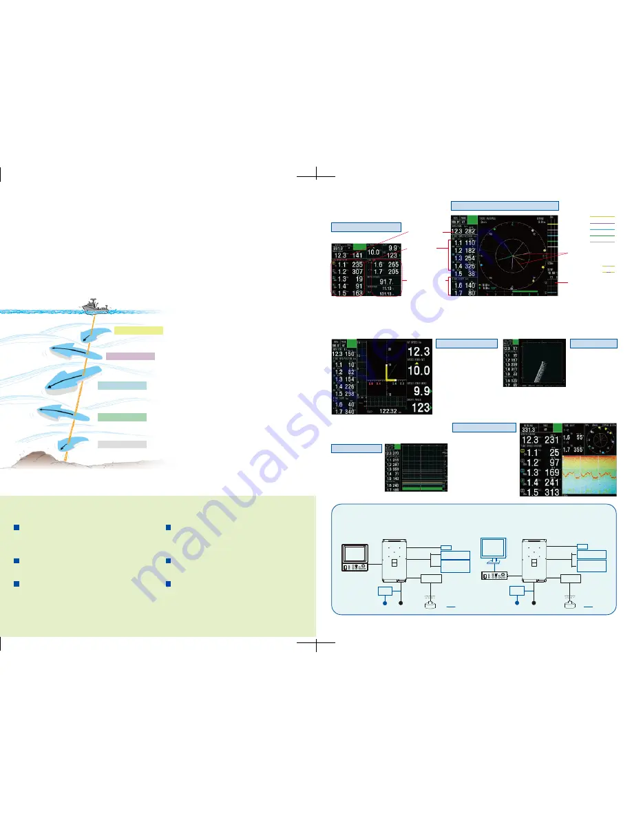
INTERCONNECTION DIAGRAM
TIDE VECTOR
SHIP'S SPEED
TEXT
TRACK
TIDE LOG
ECHO LEVEL
Ship's speed
and course
Tide speed
and direction
Tide differences
Water temperature
(external temp.
sensor required)
Tide vectors for
speed and direction
Layer 1
Layer 2
Layer 3
Layer 4
Layer 5
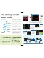
Tide speed and direction for the three depth layers are displayed with vectors.
The depth of each layer can be set manually in 1 m intervals. Other information
such as tide differential between the reference and one of the two other layers,
heading and course can also be displayed in large text.
Displays the speed
components for fore-aft
and port-stbd. The
synthesized vector (green
line) intuitively shows drift
direction. The speed
source is selectable on
the menu from ground
tracking or water tracking.
Tide vectors can be
shown on the ship's
track in user
specified intervals.
Displays the tide
information over
the past twelve
hours.
Displays echogram
obtained from each
beam. It helps evaluate
the concentration or
distribution of fish school
or seabed at three
directions simultaneously.
Tide vectors for tide
differences between
Layer 1 and 5
Layer 1 and 2
Obtain highly accurate water current
measurement using Furuno’s reliable
acoustical technology.
The FURUNO CI-68 is a Doppler Sonar Current
Indicator designed for various types of fish and
hydrographic survey vessels.
The CI-68 displays tide speed and direction at
five depth layers and ship’s speed on a high defi-
nition 10.4” color LCD. Using this information,
you can predict net shape and plan when to
throw your net.
The CI-68 has a triple-beam emission system for
providing highly accurate current measurement.
This system greatly reduces the effects of the
rolling, pitching and heaving motions, providing a
continuous display of tide information.
When ground (bottom) reference is not available
acoustically in deep water, the CI-68 can provide
true tide current information by receiving position
and speed data from a GPS navigator and head-
ing data from the satellite (GPS) compass SC-
50/110 or gyrocompass. In addition, navigation
information, including position, course and ship’s
track, can also be displayed.
The CI-68 consists of a display unit, processor
unit and transducer. The control unit and display
unit can be installed separately for flexible instal-
lation. A BlackBox configuration (without moni-
tor) is also available. CI-60G users can easily up-
grade without drydocking to CI-68 since it uses
the same transducer as the CI-60G.
Transceiver Unit
CI-6810
10/20 m
5/10/15/
20/30 m
24 VDC
Display Unit*
MU-100C
Control Unit*
CI-6888-5E
Gyro
10/20/
30/50 m
AD-10
Satellite Compass
SC-50/110
NMEA0183
GPS
Echo Sounder
Scaning Sonar
Option
115/230 VAC
DC/AC
Inverter
*Display unit and control unit
can be mounted separately
with an optional cable
Junction Box
CI-630
BlackBox configuration (with custom monitor)
24 VDC 115/230 VAC
Control Unit
CI-6888-5E
Gyro
10/20/
30/50 m
AD-10
Satellite Compass
SC-50/110
NMEA0183
GPS
Echo Sounder
Scaning Sonar
VGA Monitor
Option
Transceiver Unit
CI-6810
DC/AC
Inverter
10/20 m
5/10/15/
20/30 m
Junction Box
CI-630
Standard configuration (with standard LCD monitor)
The absolute movements of tide
measuring layers is displayed in colors.
Tide vector for Layer 1
Tide vector for Layer 2
Tide vector for Layer 3
Tide vector for Layer 4
Tide vector for Layer 5


