Increase your fishing efficiency by using
highly accurate current information
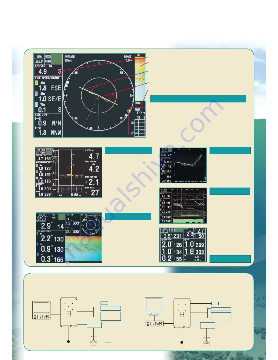
INTERCONNECTION DIAGRAM
BlackBox configuration (with custom monitor)
Standard configuration (with standard LCD monitor)
24 VDC
10/20 m
5/10/15/
20/30 m
Display Unit*
MU-100C
Control Unit*
CI-6888
Gyro
10/20/
30/50 m
AD-10
Satellite Compass
NMEA0183
GPS
Echo Sounder
Scaning Sonar
Option
Transceiver Unit
CI-8810
*Display unit and control unit
can be mounted separately
with an optional cable
Junction Box
CI-630
24 VDC
Control Unit
CI-6888
Gyro
10/20/
30/50 m
AD-10
Satellite Compass
NMEA0183
GPS
Echo Sounder
Scaning Sonar
VGA Monitor*
Option
Transceiver Unit
CI-8810
10/20 m
5/10/15/
20/30 m
Junction Box
CI-630
*640 x 480 pixels
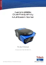
Increase your fishing efficiency by using
highly accurate current information
TIDE VECTOR
SHIP'S SPEED
TEXT
TRACK
TIDE LOG
ECHO LEVEL
Tide speed and direction for the three depth layers
are displayed with vectors. The depth of each
layer can be set manually in 1 m intervals. Other
information such as tide differential between the
reference and one of the two other layers, heading
and course can also be displayed in large text.
Displays the speed
components for fore-
aft and port-stbd. The
synthesized vector (green
line) intuitively shows
drift direction. The speed
source is selectable on the
menu from ground tracking
or water tracking.
Displays echogram
obtained from each
beam. It helps evaluate
the concentration or
distribution of fish school
or seabed at three
directions simultaneously.
Tide vectors can
be shown on the
ship's track in user-
specified intervals.
Displays the tide
information over
the past twelve
hours.
Ship’s speed and course
Echograms
Water temperature
(external temp. sensor required)
Tide vectors for speed and direction
Layer 1, 2 and 3
Tide vectors for tide differences
Layer 1 and 2
Layer 1 and 3