2. PLOTTER DISPLAYS
2-8
2.7
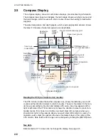
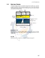
GPS Status Display
The GPS status display provides data on the GPS satellites.
GPS status display
33 18.426N
12:09 AM
1.00
Apr/02/04
ACQUIRING
LONGITUDE
LATITUDE
HDOP
SOG Kts
DATE
TIME
131 48.608W
12.5
07 14 25 31 -- --
01 11 20 28 -- --
07
01
11
14
25
31
28
Position
DOP value
Receive signal level:
Bars show satellite
signal level. Satellites
in brown are used in
fixing position.
Estimated position in the sky,
and satellite number in brown circle
is used for positioning.
www.reelschematic.com
www.reelschematic.com

