6 - WPT PAGES
124
190-00357-00 Rev G
Airport Location
Airport Location Page
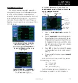
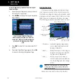
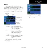
The Airport Location Page displays the latitude,
longitude, and elevation of the selected airport. The
Airport Location Page also displays facility name and
location, as well as fuel availability, best available
instrument approach, radar coverage and airspace type.
Identifier, Symbol
and Type
Latitude/Longitude
Position
Facility Name and
Location (City)
Field Elevation
Available Fuels
Radar Availability
Airspace Type
First Page in
WPT Group
Best Available Approach
and Radar Coverage
The following descriptions and abbreviations are
used:
• Type —
Usage type: Public, Military,
Heliport, or Private
• Position — Latitude/Longitude (degrees/min-
utes or degrees/minutes/seconds),
MGRS or UTM/UPS
• Elevation — In feet or meters
• Fuel —
For public-use airports, the
available fuel type(s) are: Avgas
(80-87/100LL/100-130/Mogas),
Jet, or None
• Approach — Best available approach: ILS, MLS,
LOC, LDA, SDF, GPS, VOR, RNAV
(“RNV”), LORAN (“LOR”), NDB,
TACAN (“TCN”), Helicopter
(“HEL”), or VFR
• Radar —
Radar coverage: Yes or No
• Airspace — Control environment: Class C,
CTA, TMA, TRSA, Class B or
none
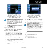
Airport Location Page indicating radar
coverage and airspace type. The Airport Loca-
tion Page also indicates the best available
approach for the selected airport. To see
additional approach information, select the
Airport Approach Page.
NOTE:
Upon active navigation changes, the active
destination airport is used as the default airport on the
WPT pages. Manual selection of the destination airport
is available from the page menu.
Summary of Contents for 500W Series
Page 1: ...500W Series Pilot s Guide Reference ...
Page 10: ...INTRODUCTION viii 190 00357 00 Rev G Blank Page ...
Page 68: ...2 NAV PAGES 58 190 00357 00 Rev G Blank Page ...
Page 92: ...4 FLIGHT PLANS 82 190 00357 00 Rev G Blank Page ...
Page 158: ...6 WPT PAGES 148 190 00357 00 Rev G Blank Page ...
Page 234: ...APPENDIX D Index 224 190 00357 00 Rev G Blank Page ...
Page 235: ......

