background image

*The device withstands incidental exposure to water of up to 1 m 

for up to 30 min. For more information, go to 

www.garmin.com

/waterrating

.

T9 Dog Collar Device Specifications

Battery type

Internal rechargeable lithium-ion battery

Battery life

From 20 to 40 hr.

Operating temperature range From -20° to 60°C (from -4° to 140°F)
Charging temperature range

From 0° to 40°C (from 32° to 104°F )

ANT

®

 wireless range

Up to 10 m (33 ft.)

Water rating

1 ATM*

*The device withstands pressure equivalent to a depth of 10 m. 

For more information, go to 

www.garmin.com/waterrating

.

Battery Information

 WARNING

This product contains a lithium-ion battery. To prevent the 

possibility of personal injury or product damage caused by 

battery exposure to extreme heat, store the device out of direct 

sunlight.
Do not use a sharp object to remove batteries.
The temperature rating for the device may exceed the usable 

range of some batteries. Alkaline batteries can rupture at high 

temperatures.

 CAUTION

Contact your local waste disposal department to properly 

recycle the batteries.

NOTICE

Alkaline batteries lose a significant amount of their capacity as 

the temperature decreases. Use lithium batteries when 

operating the device in below freezing conditions.

Long-Term Storage

NOTICE

The normal long-term decrease in the charging capacity of 

lithium-ion batteries can be accelerated by exposure to elevated 

temperatures. Storing a fully charged device in a location with a 

temperature outside the long-term storage temperature range 

can significantly reduce its recharging capacity.

When you do not plan to use the handheld device for several 

months, the battery should be removed. Stored data is not lost 

when the battery is removed.
When you do not plan to use the collar for several months, the 

battery should be charged to about 50%. The device should be 

stored in a cool, dry place with temperatures around the typical 

household level. After storage, the collar should be fully 

recharged before use.

Data Management

You can store files on your device. The device has a memory 

card slot for additional data storage.

NOTE: 

The device is not compatible with Windows

®

 95, 98, Me, 

Windows NT

®

, and Mac

®

 OS 10.3 and earlier.

File Types

The handheld device supports these file types.
• Files from BaseCamp. Go to 

www.garmin.com/trip_planning

.

• JPEG photo files.
• GPX geocache files. Go to 

www.geocaching.com/play

.

• GPI custom POI files from the Garmin POI Loader. Go to 

www.garmin.com/products/poiloader

.

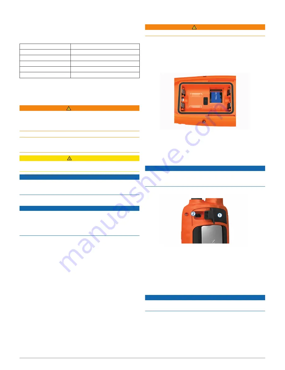
Installing a Memory Card

 WARNING

Do not use a sharp object to remove user-replaceable batteries.

You can install a microSD memory card in the handheld device 

for additional storage or pre-loaded maps.

1

Turn the D-ring counter-clockwise, and pull up to remove the 

cover.

2

Remove the battery.

3

Slide the card holder to the left and lift up.

4

Place the memory card with the gold contacts facing down.

5

Close the card holder.

6

Slide the card holder to the right to lock it.

7

Replace the battery and cover.

Connecting the Handheld Device to a Computer

NOTICE

To prevent corrosion, thoroughly dry the USB port, the weather 

cap, and the surrounding area before charging or connecting to 

a computer.

1

Lift the weather cap 

À

.

2

Plug the small end of the USB cable into the mini-USB 

connector 

Á

 on the device.

3

Plug the other end of the USB cable into an available USB 

port on the computer.
Your device and memory card (optional) appear as 

removable drives in My Computer on Windows computers 

and as mounted volumes on Mac computers.

Connecting the Collar to a Computer

NOTICE

To prevent corrosion, you should dry the contacts on the collar 

and the surrounding area before connecting the charging clip.

You can connect the collar to your computer to use with 

programs like BaseCamp. The collar is not a mass storage 

device.

1

Snap the charging clip onto the collar.

2

Plug the small end of the USB cable into the mini-USB port 

on the charging clip cable.

12

Device Information

Summary of Contents for ASTRO 900/T9

Page 1: ...ASTRO 900 T9 Owner sManual ...

Page 2: ...oncerning the use of this product Garmin the Garmin logo ANT Astro BlueChart City Navigator and TracBack are trademarks of Garmin Ltd or its subsidiaries registered in the USA and other countries BaseCamp and chirp are trademarks of Garmin Ltd or its subsidiaries These trademarks may not be used without the express permission of Garmin Windows is a registered trademark of Microsoft Corporation in ...

Page 3: ...m in on the map OUT Select to zoom out on the map MAP Select to view the map MENU Select to open the menu for the active page Select twice to open the main menu ENTER Select to select options and acknowledge messages BACK Select to cancel data entry or return to the previous menu or page MARK Select to mark your current location DOG Select to view the dog tracking page Select to view or scroll thr...

Page 4: ... tick spray that is applied to the dog is completely dry before placing the collar on the dog Small amounts of harsh chemicals can damage the plastic components and collar laminate Before you can put the collar on the dog you must pair the handheld device and collar Adding a Dog to the Astro 900 Handheld page 4 and acquire satellite signals Acquiring Satellite Signals page 2 1 Position the collar ...

Page 5: ...evice Hunt Metrics Hunt metrics provides a collection of data that helps you understand the hunting patterns and behaviors of your dog The hunt metrics reset automatically at the beginning of each new hunt Data Fields Distance The total distance the dog traveled Dog Score A combination of metrics that indicates how well a dog performed on a hunt On Point The number of times and the locations where...

Page 6: ...rson can track your dog and access the collar settings 1 Select Dog List 2 Select a dog 3 Select Show Info Assigning a Dog ID Manually Before you can assign a dog ID manually you must turn on the dog collar device and bring it within 3 m 10 ft of the handheld device You must assign a new ID number to the dog 1 Select DOG 2 Select a dog 3 Select Show Info MENU Change ID 4 Select an unassigned and n...

Page 7: ...int waiting at least 90 minutes between samples Projecting a Waypoint You can create a new location by projecting the distance and bearing from a marked location to a new location 1 From the main menu select Tools Waypoint Mgr 2 Select a waypoint 3 Select MENU Project Waypoint 4 Follow the on screen instructions 5 Select an option To save the waypoint information select Save To save and edit the w...

Page 8: ...Track Manager Current Track View Map 2 Select TracBack The map page opens with your route marked with a magenta line 3 Navigate using the map Map page 6 or the compass Navigating with the Bearing Pointer page 7 Archiving a Track Manually You can archive saved tracks to save memory space 1 Select Tools Track Manager 2 Select a track 3 Select Archive Archiving Tracks Automatically 1 Select Setup Tra...

Page 9: ...ar Another Waypoint 1 From the main menu select Tools Waypoint Mgr 2 Select a waypoint 3 Select MENU Find Near Here 4 Select a category The list includes waypoints near the original waypoint Navigating with Sight N Go You can point the device at an object in the distance lock in the direction and navigate to the object 1 Select Tools Sight N Go 2 Point the device at an object 3 Select Lock Directi...

Page 10: ...menu select Tools Geocaches 2 Select a geocache 3 Select Go When a geocache is found the handheld device marks the cache as found logs an entry into the calendar and shows the nearest cache Filtering the Geocache List You can filter your geocache list based on certain factors such as the level of difficulty 1 From the main menu select Tools Find Geocaches MENU Apply Filter Quick Filter 2 Select it...

Page 11: ...ize 4 Select the new data field For data field descriptions see Data Fields page 14 Profiles Profiles are a collection of settings that optimize your device based on how you are using it For example the settings and views are different when you use the device for hunting than when geocaching Profiles are associated with the activity screens including the home screen When you are using a profile an...

Page 12: ... pressure 1 Select Setup Units 2 Select a measurement type 3 Select a unit of measure for the setting Time Settings Select Setup Time Time Format Sets the device to show time in a 12 hour or 24 hour format Time Zone Sets the time zone for the device Automatic sets the time zone automatically based on your GPS position Position Format Settings NOTE Do not change the position format or the map datum...

Page 13: ...ement Select Setup About Support and Updates You can update software and maps for your handheld device using Garmin Express You can update software for your dog collar device using Garmin WebUpdater Product Updates On your computer install Garmin Express www garmin com express This provides easy access to these services for Garmin devices Software updates Map updates Product registration Setting U...

Page 14: ... temperatures around the typical household level After storage the collar should be fully recharged before use Data Management You can store files on your device The device has a memory card slot for additional data storage NOTE The device is not compatible with Windows 95 98 Me Windows NT and Mac OS 10 3 and earlier File Types The handheld device supports these file types Files from BaseCamp Go t...

Page 15: ...ies including a heart rate monitor or a cadence sensor with your device These accessories use ANT wireless technology to send data to the device Before you can use the fitness accessory with your device you must install the accessory according to the instructions included with the accessory Using Optional Fitness Accessories 1 Bring the device within range 3 m 10 ft of the ANT accessory 2 Select S...

Page 16: ... tip in the end piece 5 Push in the end piece and rotate it clockwise to lock it back into the vehicle power cable à Data Fields Accuracy of GPS The margin of error for your exact location For example your GPS location is accurate to within 12 ft 3 65 m Ambient Pressure The uncalibrated environmental pressure Ascent Average The average vertical distance of ascent since the last reset Ascent Maximu...

Page 17: ...e the last reset Trip Time Total A running tally of the total time spent moving and not moving since the last reset Turn The angle of difference in degrees between the bearing to your destination and your current course L means turn left R means turn right You must be navigating for this data to appear Update Rate The frequency at which the collar sends data to the handheld device Velocity Made Go...

Page 18: ...support garmin com August 2018 190 02415 00_0A ...

Reviews: