

190-00820-08 Rev. A
Cirrus Perspective
™
by Garmin – Pilot’s Guide for the SR20/SR22SR22T
375
HAZARD AVOIDANCE
SY
STEM
O
VER
VIEW
FLIGHT
INSTRUMENTS
EIS
AUDIO P
ANEL
& CNS
FLIGHT
MANA
GEMENT
HAZARD
AV
OID
ANCE
AFCS
ADDITIONAL
FEA
TURES
APPENDICES
INDEX
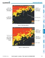
6.6 TERRAIN-SVS
WARNING:
Do not use Terrain-SVS information for primary terrain avoidance. Terrain-SVS is intended only
to enhance situational awareness.
NOTE:
Terrain-SVS is standard when the Synthetic Vision System (SVS) option is installed. The TAWS-B
option will take precedence over Terrain-SVS.
NOTE:
Terrain-SVS is information is not displayed if the aircraft is outside of the installed terrain database
coverage area.
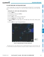
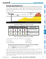
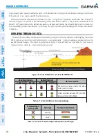
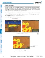
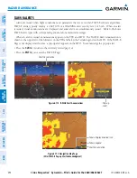
Perspective™ Terrain-SVS is a terrain awareness system integrated with the optional Synthetic Vision System
(SVS). Terrain-SVS provides visual and auditory alerting to indicate the presence of threatening terrain or obstacles
relevant to the projected flight path. For detailed information regarding SVS, refer to the Synthetic Vision System
(SVS) section of the Perspective
™
Pilot’s Guide.
Terrain-SVS does not comply with TSO-C151b certification standards. It increases situational awareness and
aids in reducing controlled flight into terrain (CFIT). Do not confuse Terrain-SVS with Terrain Awareness and
Warning System (TAWS). TAWS is more sophisticated and robust, and it is TSO-C151b certified. Although the
terrain and obstacle color map displays are the same, TAWS uses more sophisticated algorithms to assess aircraft
distance from terrain and obstacles and provides additional alerting capabilities.
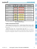
Terrain-SVS does not provide the following:
• Premature Descent Alerting (PDA)
• Excessive Descent Rate (EDR)
• Negative Climb Rate (NCR)
• Descent to 500 Feet Callout (DFC)
Terrain-SVS requires the following components to operate properly:
• Valid 3-D GPS position
• Valid terrain/obstacle database
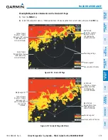
Terrain-SVS displays altitudes of terrain and obstructions relative to the aircraft position and altitude with
reference to a database that may contain inaccuracies. Terrain and obstructions are shown only if they are in the
database. Terrain and obstacle information should be used as an aid to situational awareness. They should never
be used to navigate or maneuver around terrain.
Note that all obstructions may not be available in the terrain and obstacle database. No terrain and obstacle
information is shown without a valid 3-D GPS position.
The Perspective
™
GPS receiver provides the horizontal position and altitude. GPS altitude is derived from
satellite position. GPS altitude is then converted to the height above geodetic sea level (GSL), which is the height
above mean sea level calculated geometrically. GSL altitude is used to determine terrain and obstacle proximity.
GSL altitude accuracy is affected by satellite geometry, but is not subject to variations in pressure and temperature
Summary of Contents for Cirrus Perspective SR20
Page 1: ... Cirrus SR20 SR22 SR22T Integrated Avionics System Pilot s Guide ...
Page 2: ......
Page 655: ......


