


Low Power Mode
The compass page displays the
time of day
À
, direction of travel in
degrees
Á
, and cardinal direction
Â
.
The altimeter page displays the
time of day
À
, pressure altitude
Á
, and barometric pressure
Â
.
The temperature page displays the
time of day
À
, temperature
Á
,
and density altitude
Â
.
Tracking or Navigation Modes
The compass page displays the
bearing to the nearest airport
À
,
compass ring
Á
, and direction of
travel in degrees
Â
(tracking
mode only).
The horizontal situation indicator
(HSI) displays the course line
pointer
À
, bearing to the next
waypoint
Á
, to-and-from indicator
Â
, and course deviation indicator
(CDI)
Ã
. The dots
Ä
indicate the
distance of deviation (navigation
mode only).
The altimeter page displays the
alert altitude
À
pressure altitude
Á
, and
barometric pressure
Â
.
The temperature page displays the
time of day
À
, temperature
Á
,
and density altitude
Â
.
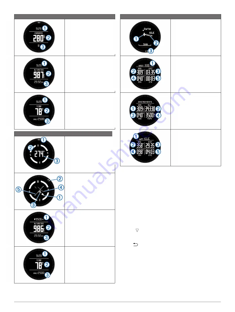
Tracking or Navigation Modes
The map displays your current
location and direction
À
, the route
to your next waypoint
Á
, and the
bearing to your next waypoint
Â
.
The nearest airport page displays
the airport identifier
À
, bearing to
the airport
Á
, distance to the
airport
Â
, track over ground
Ã
,
and the estimated time to the
airport
Ä
.
The instruments page displays
your ground speed
À
, altitude
Á
,
track over ground
Â
, and the
vertical speed in feet per minute
Ã
.
The next waypoint page displays
the waypoint name
À
, bearing to
the waypoint
Á
, distance to the
waypoint
Â
, track over ground
Ã
,
and the estimated time to the next
waypoint
Ä
(navigation mode
only).
Acquiring Satellite Signals and Recording a
Track
Before you can use the GPS navigation features, such as
recording a track, you must acquire satellite signals.
The time and date are set automatically based on the GPS
position.
1
Select the action key.
2
Select
Start GPS
.
3
Go to an area with a clear view of the sky and remain
stationary while the device acquires satellite signals.
4
Walk around or travel to record a track.
Your distance and time appear.
5
Select to view the loop of data pages.
You can customize some data pages. See the owner's
manual (
).
6
Hold
.
7
Select an option:
• Select
Pause Track
to pause tracking.
• Select
Save Track
to save your track.
• Select
Clear Track
to erase the track without saving.
• Select
Stop GPS
to turn off GPS without deleting your
track.
Stopping GPS
1
Select the action key.
2
Select
Stop GPS
.
2


