


Table of Contents
Introduction......................................1
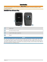
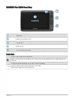
ECHOMAP Plus 40 Device View............. 1
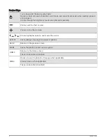
Device Keys..........................................2
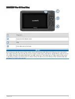
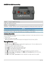
ECHOMAP Plus 60 Front View............... 3
Device Keys..........................................4
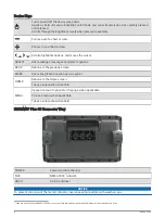
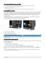
ECHOMAP Plus 60 Connector
View...................................................... 4
ECHOMAP Plus 70/90 Front View......... 5
Device Keys..........................................5
ECHOMAP Plus 70/90 Connector
Tips and Shortcuts.................................. 6
Accessing the Manuals from the
Selecting the GPS Source................... 8
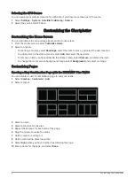
Customizing the Chartplotter............8
Customizing the Home Screen...............8
Customizing Pages................................. 8
Creating a New Combination Page
with the ECHOMAP Plus 70/90.......... 8
Creating a New Combination Page
with the ECHOMAP Plus 60................ 9
Creating a New Combination Page
with the ECHOMAP Plus 40................ 9
Customizing the Data Overlays........ 10
ActiveCaptain App.......................... 11
ActiveCaptain Roles.............................. 11
Getting Started with the ActiveCaptain
ActiveCaptain App................................ 14
Updating Charts with ActiveCaptain.... 14
Charts and 3D Chart Views............. 15
Navigation Chart and Fishing Chart..... 15
Zooming In and Out of the Chart...... 15
Panning the Chart with the Keys...... 16
Selecting an Item on the Map Using
Chart................................................... 16
Creating a Waypoint on the Chart.... 16
Navigating to a Point on the Chart... 17
Viewing Location and Object
Information on a Chart...................... 17
Viewing Details about Navaids.........17
Heading Line and Angle Markers..... 18
Premium Charts.................................... 19
Viewing Tide Station Information.....19
Showing Satellite Imagery on the
Navigation Chart................................20
Viewing Aerial Photos of
Landmarks......................................... 21
Automatic Identification System......... 21
AIS Targeting Symbols..................... 21
Heading and Projected Course of
Activated AIS Targets....................... 22
Activating a Target for an AIS
Vessel.................................................22
Viewing a List of AIS Threats........... 22
Setting the Safe-Zone Collision
Alarm.................................................. 23
AIS Aids to Navigation...................... 23
AIS Distress Signals.......................... 24
Turning Off AIS Reception................ 25
Chart Menu............................................ 25
Chart Layers.......................................26
Fish Eye 3D Settings......................... 29
Supported Maps.................................... 29
Mapping......................................... 29
Mapping a Body of Water Using the
Garmin Quickdraw Contours Feature.. 30
Adding a Label to a Garmin Quickdraw
Contours Map........................................ 30
Garmin Quickdraw Community............ 30
Connecting to the Garmin Quickdraw
Community with ActiveCaptain........ 30
Table of Contents
i