Garmin G1000 Pilot’s Guide for the Diamond DA42NG
190-00962-02 Rev. A
142
FLIGHT MANAGEMENT
SY
STEM
O
VER
VIEW
FLIGHT
INSTRUMENTS
EIS
AUDIO P
ANEL
& CNS
FLIGHT
MANA
GEMENT
HAZARD
AV
OID
ANCE
AFCS
ADDITIONAL FEA
TURES
APPENDICES
INDEX
TOPOGRAPHY
All navigation maps can display various shades of topography colors representing land elevation, similar
to aviation sectional charts. Topographic data can be displayed or removed as described in the following
procedures. Topographic data can also be displayed on the selectable profile map at the bottom of the navigation
map.
Displaying/removing Profile View
1)
From the Navigation Map Page, press the
MAP
Softkey.
2)
Press the
PROFILE
Softkey to enable or disable Profile View.
Or:
1)
Press the
MENU
Key.
2)
Select ‘Show Profile View’ or ‘Hide Profile View’ and press the
ENT
Key.
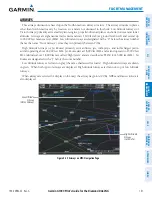
Navigation Map
Black Background
TOPO Off
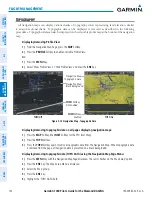
Figure 5-14 Navigation Map - Topographic Data
TOPO
Softkey
Enabled
Navigation Map
Topographic Data
TOPO On
TOPO
Softkey
Not Enabled
Displaying/removing topographic data on all pages displaying navigation maps:
1)
Press the
MAP
Softkey (the
INSET
Softkey for the PFD Inset Map).
2)
Press the
TOPO
Softkey.
3)
Press the
TOPO
Softkey again to remove topographic data from the Navigation Map. When topographic data
is removed from the page, all navigation data is presented on a black background.
Displaying/removing topographic data (TOPO DATA) using the Navigation Map Page Menu:
1)
Press the
MENU
Key with the Navigation Map Page displayed. The cursor flashes on the ‘Map Setup’ option.
2)
Press the
ENT
Key. The Map Setup Menu is displayed.
3)
Select the ‘Map’ group.
4)
Press the
ENT
Key.
5)
Highlight the ‘TOPO DATA’ field.


