190-00962-02 Rev. A
Garmin G1000 Pilot’s Guide for the Diamond DA42NG
421
HAZARD AVOIDANCE
SY
STEM
O
VER
VIEW
FLIGHT
INSTRUMENTS
EIS
AUDIO P
ANEL
& CNS
FLIGHT
MANA
GEMENT
HAZARD
AV
OID
ANCE
AFCS
ADDITIONAL
FEA
TURES
APPENDICES
INDEX
In addition to the ADS-R service, a GBT may also provide the Traffic Information Service-Broadcast (TIS-B)
data, if it is available. TIS-B relies on secondary surveillance radar (SSR) data, which detects Mode A, C, and
S transponder traffic within the radar service area. The TIS-B service is not available in areas without radar
surveillance, or when the aircraft is outside of the radar service area. The system may display radar-derived
TIS-B traffic with degraded positional accuracy compared to UAT or 1090 ES traffic, which self-report GPS
positions about once a second. TIS-B does not detect aircraft without operating transponders.
GDL 90 traffic is intended to be used both in-flight and on the airport surface. Systems should be enabled,
and remain enabled, whenever operating in the air and on the airport surface, unless ATC issues a request to stop
the transmission. This can be accomplished by selecting the transponder standby mode, which also disables
the GDL 90 UAT broadcast. See the Audio Panel and CNS Section for more information about transponder
controls.
The traffic displays are
not
intended to be used as a collision avoidance system and the system not relieve
the pilot’s responsibility to “see and avoid” other aircraft. The traffic displays must not be used for avoidance
maneuvers during IMC or other times when there is no visual contact with the intruder aircraft. The ADS-B
system is intended only to assist in visual acquisition of other aircraft. It does not provide avoidance maneuvers.
TRAFFIC DESCRIPTION
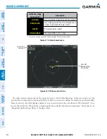
UAT traffic operation is similar to the TAS system discussed previously in section 6.10, with the exception
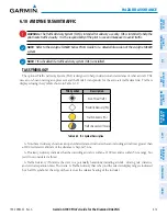
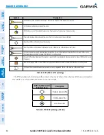
of symbology. The system displays the traffic using the symbols shown in the table below. Above or below
the traffic symbol is the traffic identifier, and altitude (if available). A small up or down arrow next to the traffic
symbol indicates that the traffic is climbing or descending at a rate of at least 500 feet per minute. The vector
line that extends beyond the point of the traffic arrow is just further indication of the intruder aircraft track,
if directional information is available.


