

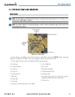
GPS NAVIGATION
190-00692-00 Rev. B
5-19
Garmin G1000 Pilot’s Guide for Piper PA32
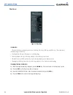
Airway Line Style
The route of low altitude airways are drawn in gray (the same shade used for roads). Note that VFR
sectional charts use light blue for low altitude airways – but on the G1000, that color has the potential to
be confused with airspace boundaries.
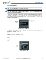
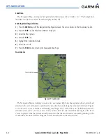
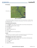
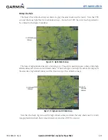
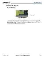
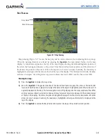
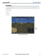
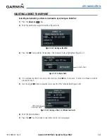
Hi Altitude
Airways
Figure 5-12 High Altitude Airways
The route of high altitude airways are drawn in green. This color is used on Jeppesen charts where high
altitude airways are shown on low altitude charts. When both types of airways are selected for display at
the same time, high altitude airways will be drawn on top of low altitude airways.
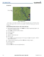
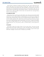
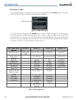
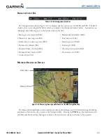
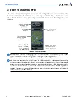
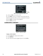
Figure 5-13 High and Low Altitude Airways
Hi Altitude
Airways
Low
Altitude
Airways
Note that the shade of green used for high altitude airways is darker than any shade used to render
topographical detail such that it should stand out even when TOPO is selected.
Summary of Contents for G1000:Piper
Page 1: ...Piper PA32...
Page 50: ...190 00692 00 Rev B Garmin G1000 Pilot s Guide for Piper PA32 1 40 SYSTEM OVERVIEW BLANK PAGE...
Page 438: ...190 00692 00 Rev B Garmin G1000 Pilot s Guide for Piper PA32 D 6 APPENDIX D BLANK PAGE...
Page 444: ...190 00692 00 Rev B Garmin G1000 Pilot s Guide for Piper PA32 F 4 APPENDIX F BLANK PAGE...
Page 450: ...Garmin G1000 Pilot s Guide for Piper PA32 190 00692 00 Rev B I 6 INDEX BLANK PAGE...