background image

47

G500 Cockpit Reference Guide

190-01102-03 Rev C

A

UX GROUP:

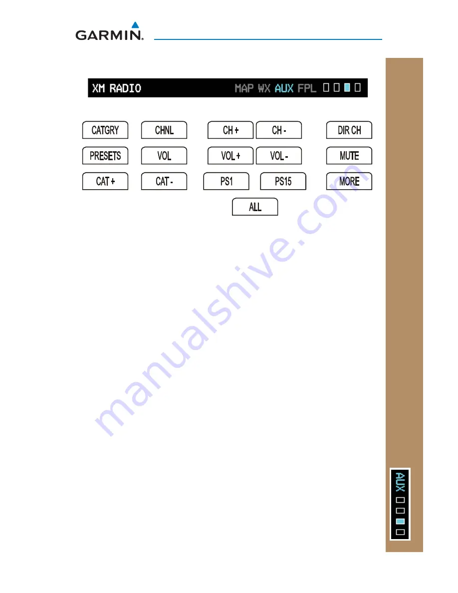
 XM RADIO P

A

GE

AUX GROUP

XM

®

 Radio Page (Optional)

Soft Keys Found on XM Radio Page


TO 


Selecting a Channel

While viewing the XM Radio page of the Aux Page Group, press the small 

1) 

MFD

 knob and then turn the small 

MFD

 knob to highlight the desired 

channel. 

Press 

2) 

ENT

 to make the highlighted channel the Active Channel. 

Press the small 

3) 

MFD

 knob to end editing. 

Press 

4) 

CHNL

 and then the 

CH+

 or 

CH- 

soft keys to increment up or down one 

channel at a time in the active category. 

Press 

5) 

CHNL

 and then the 

DIR CH

 soft key to directly select a channel in the 

active channel fi eld. Turn the small 

MFD

 knob and large 

MFD

 knob to select 

desired channel. 

Press 

6) 

ENT

 to save the selection or press the small 

MFD

 knob


to cancel 

selection.

Selecting a Channel within a Category

Press 

1) 

CATGRY

 to highlight the category window. 

Press 

2) 

CAT+

 or 

CAT-

 to cycle through the different categories or turn the small 

MFD

 knob to the category and press 

ENT

Turn the small 

3) 

MFD

 knob to move to the desired channel. 

Press 

4) 

ENT

 to make that channel the active channel.

Press the small 

5) 

MFD

 to end editing.

Summary of Contents for G500

Page 1: ...G500 Cockpit Reference Guide...

Page 2: ...this manual may be reproduced copied transmitted disseminated downloaded or stored in any storage medium for any purpose without the express written permission of Garmin Garmin hereby grants permissio...

Page 3: ...RRANTY OF MERCHANTABILITY OR FITNESS FOR A PARTICULAR PURPOSE STATUTORY OR OTHERWISE THIS WARRANTY GIVES YOU SPECIFIC LEGAL RIGHTS WHICH MAY VARY FROM STATE TO STATE IN NO EVENT SHALL GARMIN BE LIABLE...

Page 4: ...inimum clearance altitudes WARNING The Garmin GDU 620 has a very high degree of functional integrity However the pilot must recognize that providing monitoring and or self test capability for all conc...

Page 5: ...on and the relative age of the data NEXRAD weather data should not be used for short range weather avoidance WARNING For safety reasons GDU 620 operational procedures must be learned on the ground WAR...

Page 6: ...a precision electronic NAVigationAID NAVAID Therefore as with all NAVAIDs information presented by the GDU 620 can be misused or misinterpreted and therefore become unsafe CAUTION The Garmin GDU 620...

Page 7: ...m This notice is being provided in accordance with California s Proposition 65 If you have any questions or would like additional information please refer to our web site at www garmin com prop65 NOTE...

Page 8: ...Part Number Revision Date Page Range Description 190 01102 03 190 01102 03 190 01102 03 A B C 5 28 09 6 18 09 10 26 09 All Cover 55 Production Release Updated logo to meet guidelines and added Garmin...

Page 9: ...nters 12 Autopilot AP 15 Heading 15 Autopilot Test 15 Altitude Capture Optional Interface 16 Autopilot Navigation 16 Autopilot Operation with the GDU 620 Emulating GPSS 17 Additional Features 18 Garmi...

Page 10: ...al 47 System Status Page 49 Flight Plan Group 50 Active Flight Plan Page 50 Viewing Your Active Flight Plan 50 Waypoint Information Page 51 Charts Page Optional 52 Change Day Night View 52 Viewing Cha...

Page 11: ...map all displayed on dual 6 5 inch color screens The G500 system is composed of sub units or Line Replaceable Units LRUs LRUs have a modular design and can be installed directly behind the instrument...

Page 12: ...2 G500 Cockpit Reference Guide 190 01102 03 Rev C PRIMARY FLIGHT DISPLAY PFD PRIMARY FLIGHT DISPLAY Primary Flight Display PFD 1 2 4 5 6 7 8 3 9 10 11 12 14 15 13 16 17 18 Primary Flight Display PFD...

Page 13: ...ing 11 Soft Keys Used to select available options on PFD or MFD 12 SD Card Slots Upper and Lower The upper slot is used for updating databases or software the lower slot is for the database card 13 So...

Page 14: ...icator magenta line indicates what the airspeed will be in six seconds if the current rate of acceleration is maintained If the current acceleration will cause the airspeed to exceed VNE in six second...

Page 15: ...itude Trend indicates what the altitude will be in six seconds if the current vertical speed is maintained Altitude Bug Setting Altitude Trend BARO Setting Current Altitude Altitude Tape Altitude Bug...

Page 16: ...ext Once in range the Minimums Bug appears in cyan on the altitude tape A portion of the Minimums Bug will be displayed at the bottom of the altitude tape if the selected altitude minimums bug is off...

Page 17: ...highlight the Altitude Field in the MINIMUMS section on the FPL page and press the CLR key it will clear the entry and the minimums functionality will be turned off Altitude Bug The Altitude Bug is d...

Page 18: ...nd vector displays available Refer to the System Setup page in the AUX Group section of this guide for instructions on selecting wind vector style Wind Vectors can only be calculated when the aircraft...

Page 19: ...idance The GPS approach glidepath is shown in magenta G and indicator while the ILS approach glideslope is shown in green G and indicator GPS Approach Vertical Deviation Source Vertical Deviation Indi...

Page 20: ...an Attitude Indicator that has a Ground Pointer the pointer above the roll scale shifts with the roll or bank angle of the aircraft to keep the Roll Scale Zero Pointer pointing towards the ground Rol...

Page 21: ...r Roll Pointer Slip Skid Indicator Roll Scale Zero Horizontal Situation Indicator HSI Aircraft Heading The top of the HSI displays current heading current GPS track magenta diamond heading trend and t...

Page 22: ...e 2 BRG2 will be an arrow with a double line Totogglebetweentheavailablebearingpointers pressthePFDsoftkeyfollowed by the BRG1 or BRG2 soft keys The BRG1 soft key cycles through modes NAV1 and GPS1 Ad...

Page 23: ...rces available GPS1 VOR1 or LOC1 Navigation sources available GPS2 VOR2 or LOC2 if a second source is available GPS Mode The GPS Mode annunciation on the HSI will be the same as what is annunciated on...

Page 24: ...two sources of navigation GPS or NAV VOR or LOC Press the CDI soft key to toggle between the available CDI modes GPS or VOR If a second GPS source or NAV source is available pressing the 1 2 soft key...

Page 25: ...knob stops moving Engage your autopilot in heading hold mode 2 Continue to control your selected autopilot heading by adjusting the heading 3 bug on the GDU 620 Selected Heading Box on HSI Autopilot...

Page 26: ...rface The Altitude Preselect Function is a separately purchased option which works with the autopilot At the set altitude the autopilot will go from a Vertical Speed Mode a climb or descent to an Alti...

Page 27: ...t Operation with the GDU 620 Emulating GPSS NOTE The GDU 620 has the ability to emulate GPSS roll steering for autopilots that do not support GPSS The GDU 620 emulates GPSS by sending headings to the...

Page 28: ...ive SVT information is shown on the PFD SVT offers a three dimensional view of terrain and obstacles Terrain and obstacles that pose a threat to the aircraft in flight are shaded yellow or red Obstacl...

Page 29: ...SYN VIS soft key then the SYN TERR soft key NOTE SVT features are not a substitute for standard course and altitude deviation information using the CDI VSI and VDI Displaying Garmin SVT Terrain Press...

Page 30: ...Knob Use to move within page groups 4 Enter Validates or confirms a menu selection or data entry 5 Clear Erases information cancels entries or removes page menus Pressing and holding the CLR key disp...

Page 31: ...Page are shown at the bottom of the MFD Changing Settings within a Page Press the 1 MENU key and make the necessary adjustments with the large MFD knob and small MFD knobs Press the small 2 MFD knob...

Page 32: ...WX DATA LINK MAP 1 AUX FPL ACTIVE FLIGHT PLAN WAYPOINT INFO CHARTS NAV MAP 2 DCLTR MAP TRAFFIC TOPO TERRAIN DCLTR MAP TRAFFIC TOPO TERRAIN STANDBY OPERATE ALT MODE 360 ARC WX DATA LINK MAP 2 WX DATA L...

Page 33: ...arge 2 MFD knob to move the map pointer left and right horizontally Turn the small 3 MFD knob to move the map pointer up and down vertically Press the small 4 MFD knob again to exit panning mode Selec...

Page 34: ...igation Map 1 or Navigation Map 2 of the Map Page Group press the MAP soft key Select the Traffic TOPO or Terrain overlays by pressing the appropriate soft key Measuring Distances While viewing Naviga...

Page 35: ...vailable groups Map Weather Traffic or Aviation Available Groups Press the 4 ENT key to select the group and set your preferences Turn the large 5 MFD knob to move between fields Turn the small 6 MFD...

Page 36: ...Range Off to 2500 NM Field of View On or Off WEATHER NEXRAD Data Viewing Range Off to 2000 NM NEXRAD Cell Movement Range Off to 2000 NM NEXRAD Legend XM Lightning Viewing Range Off to 2000 NM TRAFFIC...

Page 37: ...an interface traffic system the PFD will display a traffic annunciator and the MFD will have a pop up screen displaying the detected traffic To remove the pop up press the CLR key Press the ENT key to...

Page 38: ...ating Traffic Advisory Systems TAS Traffic Map TAS While viewing the Traffic Page of the Map Page Group press the 1 OPERATE soft key to begin displaying traffic TAS OPERATING is displayed in the Traff...

Page 39: ...MAL Displays traffic from 2700 to 2700 ft ABOVE Displays traffic from 2700 to 9700 ft UNREST All traffic is displayed unrestricted Press the 3 STANDBY soft key to place the system in the Standby mode...

Page 40: ...GDU 620 displays up to eight traffic targets within a 7 5 NM radius from 3000 feet below to 3500 feet above the requesting aircraft Traffic is displayed according to TCAS symbology using four differen...

Page 41: ...TAWS TAWS is TSO C151b certified and Terrain Proximity is not Terrain Proximity does not provide warning annunciations or voice alerts it only provides color indications on map displays when terrain...

Page 42: ...cles will be removed from the Terrain page when range RNG exceeds 10 NM While viewing the Terrain page of the Map Page Group press the 360 or ARC soft keys to select the desired view 360 or ARC Soft K...

Page 43: ...tions are displayed and aural alerts are simultaneously issued Refer to the Alerts section of this guide for more information on alerts both visual and aural When an alert is issued annunciations appe...

Page 44: ...que to each page Customizing the Weather Map While viewing any of the WX Data Link Map pages in the WX Page Group 1 press the MENU key to display the Weather Setup Menu Press ENT Turn the large 2 MFD...

Page 45: ...ir Viewing Range Range Off 10 NM to 2000 NM METAR Data Viewing Range Range Off 500 FT to 2000 NM Surface Data Viewing Range Range Off 10 NM to 2000 NM Surface Data Time Range Current 12 HR to 48 HR Fr...

Page 46: ...either the 3 LEGEND soft key ENT button or the small MFD knob Displaying Surface Data and Winds Aloft While viewing any of the pages in the WX Page Group if in the setup you chose to display SURFACE D...

Page 47: ...37 G500 Cockpit Reference Guide 190 01102 03 Rev C WX GROUP WX GROUP WEATHER RADAR Weather Radar Optional Weather Radar Map Page Soft Keys Found on Weather Radar Map Page Weather Radar...

Page 48: ...he last page of the WX Page Group Press the 2 MODE soft key If the aircraft is on the ground press the 3 STANDBY soft key to initiate the warm up period After the warm up is complete the radar enters...

Page 49: ...Turn the 2 small MFD knob to select FULL 60 40 or 20 scan If desired readjust the Bearing Line to change the center of the Sector Scan 3 Turn the large MFD knob to move cursor to the BEARING field an...

Page 50: ...Color Highlight WATCH WATCH Weather Attenuated Color Highlight which helps identify possible shadowing effects of short range cell activity identifying areas where radar return signals are weakened o...

Page 51: ...the AUTO the LEVEL will adjust in response to ambient light or a lighting bus as configured during installation Setting Airspeed References While viewing the System Setup Page of the Aux Page Group p...

Page 52: ...ays total wind direction with headwind and crosswind speed components Style 4 Displays total wind direction in degrees with wind speed Synchronization For Dual Installations Only NOTE The SYNCHRONIZAT...

Page 53: ...sired format and press ENT to confirm your selection Setting Time Offset While viewing the System Setup Page of the Aux Page Group press the small 1 MFD knob Turn the large MFD knob to the time offset...

Page 54: ...ting Altitude and Vertical Speed Units While viewing the System Setup Page of the Aux Page Group press the small 1 MFD knob and turn the large MFD knob to move to the desired field of the MFD DISPLAY...

Page 55: ...the next preference or press the small MFD knob to exit editing mode Setting Temperature Units While viewing the System Setup Page of the Aux Page Group press the small 1 MFD knob and turn the large...

Page 56: ...Found on XM Information Page While viewing the XM Information page of the Aux Group turn the small MFD knob to display the XM Information screen This page contains the Data Radio and Audio Radio IDs...

Page 57: ...ncrement up or down one channel at a time in the active category Press 5 CHNL and then the DIR CH soft key to directly select a channel in the active channel field Turn the small MFD knob and large MF...

Page 58: ...E soft key To restore the radio volume press MUTE again or the VOL or VOL soft keys Storing a Preset Channel While viewing the XM Radio page you may set a preset for the Active Channel Press the PRESE...

Page 59: ...e unit is present and operating properly while a red X indicates an absence or failure This page is for informational purposes and there are no items that are able to be modified System Status Page Wh...

Page 60: ...st page of the Flight Plan page group No changes to the flight plan can be made from the GDU 620 All flight plan changes must be made from the GNS unit Active Flight Plan Page While viewing the Active...

Page 61: ...the Waypoint Information page of the FPL Page Group press 1 the small MFD knob and then turn the small and large MFD knobs to select the waypoint You can also turn the small MFD knob counterclockwise...

Page 62: ...MFD knob to highlight the Display Level Brightness value Turn the small MFD knob to change the display level value for which the display will automatically switch from Day Night brightness Press the...

Page 63: ...ewing the Charts page of the FPL Page Group press the 1 SELECT soft key to change the airport or chart Turn the small and large 2 MFD knobs to select the airport identifier and press ENT to accept the...

Page 64: ...port NRST or your most recently selected airport RECENT While viewing the Charts page of the FPL Page Group press the 1 SELECT soft key Turn the small 2 MFD knob counterclockwise Turn the small 3 MFD...

Page 65: ...landmarks including ramps buildings control towers and other prominent features Resolution is greater at lower map ranges When the aircraft location is within the screen boundary including within Saf...

Page 66: ...itude monitors have detected an AHRS malfunction or the inability to actively monitor the AHRS output The autopilot will automatically disconnect This alert will display on the PFD and only appears wi...

Page 67: ...received in more than 5 seconds GWX CONFIG GWX configuration error Configuration service required GWX SERVICE GWX need service Return unit for repair HDG FAULT AHRS 1 magnetometer fault has occurred H...

Page 68: ...has failed WX ALERT Possible severe weather ahead WX RADAR FAIL Weather radar has failed Terrain SVT Alerts Terrain DSP Terrain awareness display unavailable Terrain SVT System Test Fail Terrain Syste...

Page 69: ...n towered Non serviced Airport Towered Non serviced Airport Non towered Serviced Airport Towered Serviced Airport Soft Surface Serviced Airport Soft Surface Non serviced Airport Private Airport Helipo...

Page 70: ...Description Helipad Airport Beacon Under Construction Zones Unpaved Parking Areas Traffic Symbols Symbol Description Highest to Lowest Priority Traffic Advisory TA In Range Traffic Advisory TA Out of...

Page 71: ...0 NM Potential Impact Point Unlighted Obstacle Projected Flight Path 1000 ft 100 ft Threshold Terrain more than 1000 ft below the aircraft altitude Black Terrain between 100 ft and 1000 ft below the a...

Page 72: ...2 03 Rev C SYMBOLS SYMBOLSXM Weather Toolbar Symbols Symbol Description NEXRAD Echo Top Cloud Top XM Lightning Cell movement SIGMETs AIRMETs METARs City Forecast Surface Analysis Freezing Levels Winds...

Page 73: ...ols Symbol Description Default Aircraft Ownship High Wing Aircraft Jet Aircraft Default Map Pointer Elevation Map Pointer User Waypoint Parallel Track Waypoint TFR Temporary Flight Restrictions Restri...

Page 74: ...64 G500 Cockpit Reference Guide 190 01102 03 Rev C This page intentionally left blank...

Page 75: ......

Page 76: ...d SE Salem Oregon 97302 U S A Tel 503 581 8101 or 800 525 6726 Fax 503 364 2138 Garmin Europe Ltd Liberty House Bulls Copse Road Hounsdown Business Park Southampton SO40 9RB U K Tel 44 0 870 850 1243...

Reviews: