4-96
Garmin G500H Pilot’s Guide
190-01150-02 Rev. J
For
ewor
d
Sec 1 System
Sec 2
PFD
Sec 3
MFD
Sec 4
Hazar
d
Avoidance
Sec 5
Additional Featur
es
Sec 6
Annun. & Alerts
Sec 7
Symbols
Sec 8
Glossary
Appendix A
Appendix B
Index
4.8.10 SIGMETs and AIRMETs (SIG/AIR)
SIGMETs (SIGnificant METeorological Information) and AIRMETs
(AIRmen’s METeorological Information) are broadcast for potentially hazardous
weather considered of importance to aircraft. A Convective SIGMET is issued
for hazardous convective weather. A localized SIGMET is a significant weather
condition occurring at a localized geographical position.
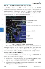
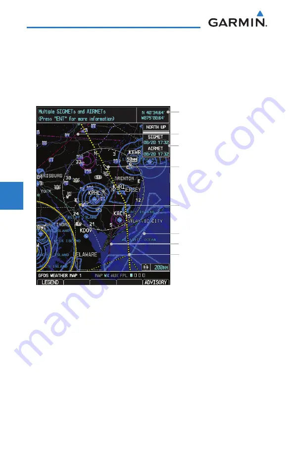
SIGMET Line
IFR Line
Cursor On AIRMET/SIGMET Line
MTN Obscures Visibility
Product Age
Cursor Location
Icing
Localized SIGMET
Figure 4-79 GFDS Weather Page - AIRMETs/SIGMETs
When enabled, SIGMET/AIRMETs advise the pilot of potentially hazardous
weather to all aircraft. SIGMET/AIRMET data covers icing, turbulence, dust,
and volcanic ash as issued by the National Weather Service. The update rate is
every 12 minutes in the U.S. Elsewhere, updates are made as they are issued.
Viewing Textual SIGMETs/AIRMETs
Textual SIGMET/AIRMETs can be viewed by selecting an SIGMET/AIRMET
line on the Map or Weather (WX) pages.
1) While viewing a Map or Weather page, Use the small and large
MFD
knobs to
move the cursor to highlight a SIGMET/AIRMET line. Press
ENT
.
2) The Waypoint Information page for that line will now be shown. Press the
WX
soft key to view weather information.
Summary of Contents for G500H
Page 1: ...G500H Pilot s Guide ...
Page 365: ......

