4-118
Garmin G500H Pilot’s Guide
190-01150-02 Rev. J
For
ewor
d
Sec 1 System
Sec 2
PFD
Sec 3
MFD
Sec 4
Hazar
d
Avoidance
Sec 5
Additional Featur
es
Sec 6
Annun. & Alerts
Sec 7
Symbols
Sec 8
Glossary
Appendix A
Appendix B
Index
4.9.5.7 METARs
NOTE:
Atmospheric pressure reported for METARs is given in hectopascals
(hPa), except in the United States, where it is reported in inches of mercury
(in Hg). Temperatures are reported in Celsius.
NOTE:
METAR information is only displayed within the installed aviation
database service area.
METAR (METeorological Aerodrome Report), known as an Aviation Routine
Weather Report, is the standard format for current weather observations.
METARs are updated hourly and are considered current. METARs typically
contain information about the temperature, dew point, wind, precipitation,
cloud cover, cloud heights, visibility, and barometric pressure. They can also
contain information on precipitation amounts, lightning, and other critical data.
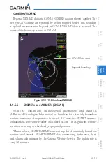
METARs are shown as colored flags at airports that provide them.
Selected METAR (VFR)
Cursor Location
Figure 4-98 FIS-B Weather - Graphic METARs
METAR Viewing Range
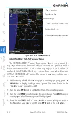
The METAR Viewing Range option allows you to select the map range where
at and below that value METAR weather products will be shown on the selected
MFD FIS-B Weather Map page (1, 2, or 3). When Off is selected, METARs will
not be shown. For a value (such as 150 NM) selected, METAR data will be
shown at map ranges of that value (150 NM), and lower.
Summary of Contents for G500H
Page 1: ...G500H Pilot s Guide ...
Page 365: ......

