GPS 400 Pilot’s Guide and Reference
190-00140-60 Rev. H
10-34
SECTION 10
ADDITIONAL FEATURES
Standard Aviation Forecast Abbreviations
The standard aviation forecast abbreviations are listed
in Table 10-12.
STANDARD AVIATION FORECAST ABBREVIATIONS
‘+’ – (Heavy)
‘-’ – (Light)
‘/’ – (Missing or separator) Axxxx – Altimeter setting
(xxxx are numbers)
AFT – After
BKN – Broken clouds
BLO – Below
BR – Light fog
CIG – Ceiling
CLR – Sky clear
DZ – Drizzle
FEW – Few clouds
FG – Thick fog
FM – From
FZ – Freezing
G – Gusts
KT – Knots
OBSCD – Obscured
OVC – Overcast clouds
Pxxxx – Hourly Precipitation
(xxxx are numbers)
PRESFR – Pressure falling
rapidly
PRESRR – Pressure rising
rapidly
RA – Rain
RMK – Remarks
SCT – Scattered clouds SLP – Sea Level Pressure
SM – Statue Miles
SN – Snow
TEMPO – Occasionally
Trrn – Terrain
TS – Thunderstorm
VV – Vertical Visibility
Table 10-12 Forecast Abbreviations
METAR Graphics
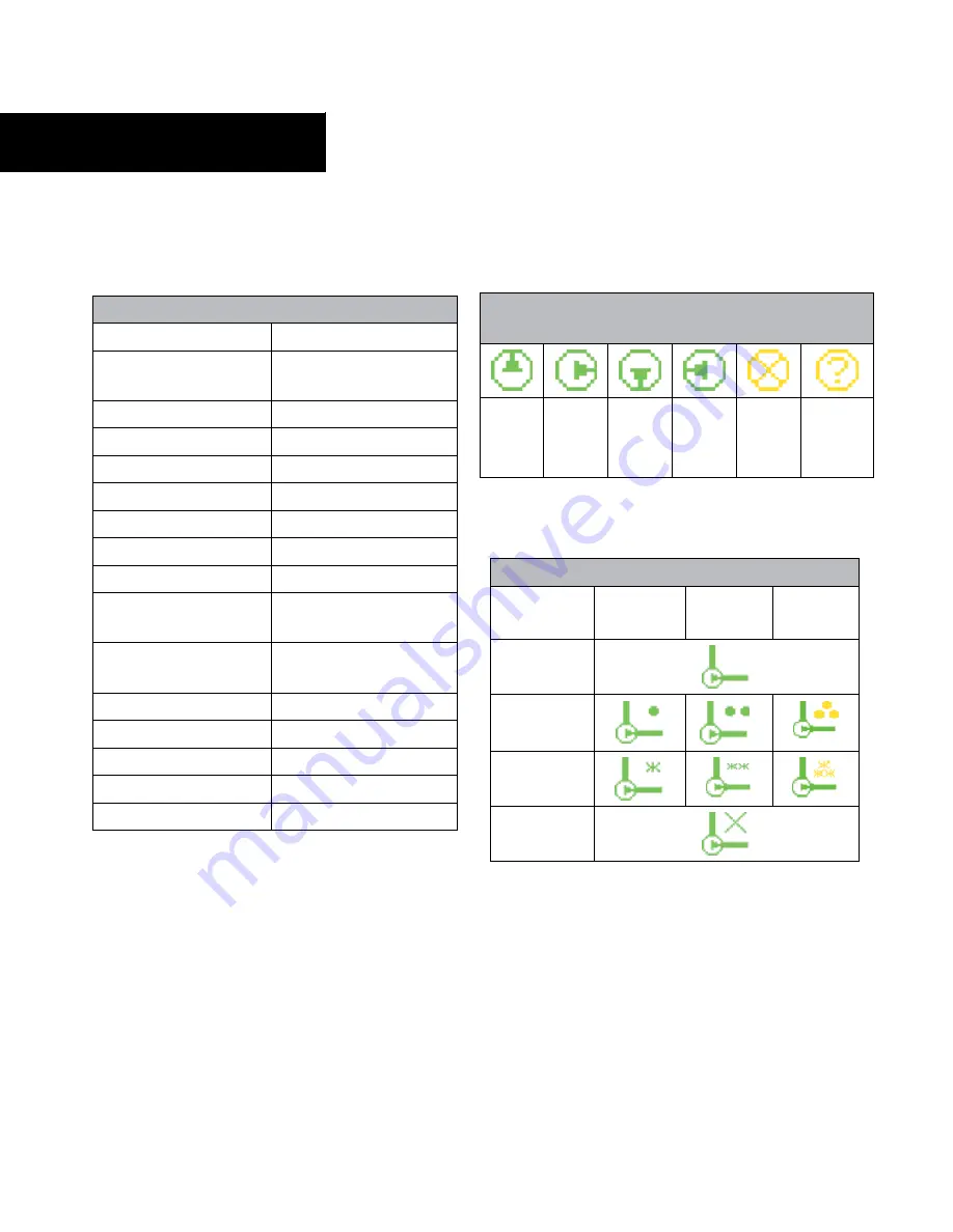
The age symbols listed in Table 10-13 are common to
METARs, Winds, and Temperature/Dewpoint graphics:
METAR, Winds, and Temperature/Dewpoints Age
Graphics
0 - 10
minutes
(Green)
11 - 20
minutes
(Green)
21 - 30
minutes
(Green)
31 - 60
minutes
(Green)
61+
minutes
(Yellow)
Unknown
(Yellow)
Table 10-13 Weather Age Graphics
METARs
Precipitation Graphics
Light
(Green)
Moderate
(Green)
Heavy
(Yellow)
No
Precipitation
Rain
Snow
Unknown
Table 10-14 Precipitation Graphics


