2
What is GPS?
GPS (Global Positioning System) is a satellite-based navigation system developed
by the U. S. Department of Defense to provide a consistent, accurate method of
simplifying navigation. Originally designed for military applications, it also pro-
vides commercial and recreational users with 24-hour, worldwide navigation cover-
age with accuracy to 15 meters (49 feet).
How Does GPS Work?
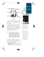
GPS navigation uses satellite ranging to determine your position in relation to a
set of satellites orbiting the earth. The GPS constellation is made up of 24 satellites,
which continuously send radio signals containing precise position and time infor-
mation for each satellite back to earth.
By knowing the position of any 3 or 4 of these satellites and calculating various
time differences between the transmitted signals, your GPS receiver can determine
its present position anywhere on earth. And once you’re under way, your GPS con-
tinuously updates your position and provides speed and track information.
What are the Advantages of GPS Navigation?
For centuries, mariners have been searching for an accurate method of travelling
the world’s waterways. From celestial navigating to loran and SatNav, each system
has had its problems with weather, range and reliability.
GPS takes navigation to a higher level by providing accurate position and course
information, anywhere in the world, regardless of the weather or your proximity to
land. The accuracy and coverage of GPS navigation can help make your boating
safer, smarter and more efficient wherever you may travel.
Introduction
GPS Overview
45 manual Rev. B 8/4/98 11:07 AM Page 2

