background image

© Copyright 2004 Garmin Ltd. or its subsidiaries

Garmin International, Inc.
1200 East 151

st

 Street, Olathe, Kansas  66062, U.S.A.

Tel. 913/397.8200 or 800/800.1020
Fax 913/397.8282

Garmin (Europe) Ltd.
Unit 5, The Quadrangle, Abbey Park Industrial Estate, Romsey, SO51 9DL, U.K.
Tel. 44/0870.8501241
Fax 44/0870.8501251

Garmin Corporation 
No. 68, Jangshu 2

nd

 Road, Shijr, Taipei County, Taiwan

Tel. 886/2.2642.9199
Fax 886/2.2642.9099

All rights reserved. Except as expressly provided herein, no part of this manual may be reproduced, copied, transmitted, disseminated, down-
loaded or stored in any storage medium, for any purpose without the express prior written consent of Garmin. Garmin hereby grants permission 
to download a single copy of this manual onto a hard drive or other electronic storage medium to be viewed and to print one copy of this manual 
or of any revision hereto, provided that such electronic or printed copy of this manual must contain the complete text of this copyright notice and 
provided further that any unauthorized commercial distribution of this manual or any revision hereto is strictly prohibited.

Information in this document is subject to change without notice. Garmin reserves the right to change or improve its products and to make 
changes in the content without obligation to notify any person or organization of such changes or improvements. Visit the Garmin web site 
(www.garmin.com) for current updates and supplemental information concerning the use and operation of this and other Garmin products.

Garmin

®

, MapSource

®

, BlueChart

®

, TracBack

®

 and GPSmap

®

 are registered trademarks of Garmin Ltd. or its subsidiaries and may not be 

used without the express permisison of Garmin. 

June 2004                                                        Part Number 190-00331-00 Rev. A 


                          Printed in Taiwan

Summary of Contents for GPS 60 - Hiking GPS Receiver

Page 1: ...map navigator owner s manual GPSMAP 60 ...

Page 2: ...orage medium to be viewed and to print one copy of this manual or of any revision hereto provided that such electronic or printed copy of this manual must contain the complete text of this copyright notice and provided further that any unauthorized commercial distribution of this manual or any revision hereto is strictly prohibited Information in this document is subject to change without notice G...

Page 3: ...se agreement FCC and safety information the Table of Contents and an overview of the GPSmap 60 functional features Getting Started takes you through installing batteries using the unit control buttons initializing the GPS receiver etc GPS Navigation takes you through the process of navigating with your GPSmap 60 and how to use GPS Navigation to customize the operation of your GPSmap 60 GPS Feature...

Page 4: ...at the Software is the property of Garmin and is protected under the United States of America copyright laws and international copyright treaties You further acknowledge that the structure organization and code of the Software are valuable trade secrets of Garmin and that the Software in source code form remains a valuable trade secret of Garmin You agree not to decompile disassemble modify revers...

Page 5: ...s However there is no guarantee that interference will not occur in a particular installation If this equipment does cause harmful interference to radio or television reception which can be determined by turning the equipment off and on the user is encouraged to try to correct the interference by one of the following measures Reorient or relocate the receiving antenna Increase the separation betwe...

Page 6: ...n CAUTION IT IS THE USER S RESPONSIBILITY TO USE THIS PRODUCT PRUDENTLY THIS PRODUCT IS INTENDED TO BE USED ONLY AS A NAVIGATIONAL AID AND MUST NOT BE USED FOR ANY PURPOSE REQUIRING PRECISE MEASUREMENT OF DIRECTION DISTANCE LOCATION OR TOPOGRAPHY THIS PRODUCT SHOULD NOT BE USED AS AN AID TO DETERMINE GROUND PROXIMITY FOR AIRCRAFT NAVIGATION CAUTION The electronic chart is an aid to navigation and ...

Page 7: ...lobal Positioning System GPS is operated by the United States government which is solely responsible for its accuracy and maintenance The system is subject to changes which could affect the accuracy and performance of all GPS equipment Although the Garmin GPSmap 60 is a precision electronic NAVigation AID NAVAID any NAVAID can be misused or misinterpreted and therefore become unsafe WARNING This p...

Page 8: ...nted against collision damage or the consequences thereof WARNING When used in vehicles it is the sole responsibility of the driver of the vehicle to operate the vehicle in a safe manner maintain full surveillance of all driving conditions at all times and not become distracted by the unit to the exclusion of safe driving practices It is unsafe to operate the controls of the unit while you are dri...

Page 9: ...ite Page 4 Navigating with the GPSmap 60 5 The Main Page Sequence 6 The Main Page Features 7 Section 3 GPS Navigation 8 56 The Map Page 8 The Compass Page 14 The Trip Computer Page 16 Using Waypoints 17 Using Find 21 The Main Menu 33 Using Tracks 34 Using Routes 39 The Highway Page 44 The Setup Menu 45 System Setup 45 Interface Setup 46 Tones Setup 48 Page Sequence Setup 48 Map Setup 49 Routing Se...

Page 10: ...Tables 61 GPS Enhanced Games 62 Non Enhanced Game 65 Section 5 Appendices 66 82 Accessories 66 Specifications 68 Data Field Definitions 70 Connecting the GPSmap 60 to a Computer 74 Downloading MapSource Map Data 75 UTC Offset Chart 76 Map Datums and Position Formats 77 WAAS and DGPS 78 Wiring Diagram 79 Index 80 Limited Warranty 82 Table of Contents ...

Page 11: ... life To set backlighting intensity and timeout see page 46 To disable WAAS see page 45 To mute the beep tones see page 48 Getting Started Installing the Batteries The GPSmap 60 operates on two AA batteries not included which are located in the back of the unit Alkaline or NiMH batteries may be used see page 45 for setting the battery type Stored data will not be lost when batteries are removed To...

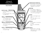
Page 12: ...NTRAST Key Press and hold to turn unit On Off Press and release to display back lighting and contrast controls ROCKER Key Move Up Down or Right Left to move through lists highlight fields on screen buttons icons enter data or move the map panning arrow PAGE Key Press to cycle through the main pages Press when using the on screen keyboard to close MENU Key Press and release to view options for a pa...

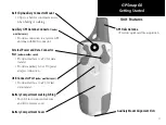
Page 13: ...wer and Data Connector Port under weather cover Provides interface to a PC for data transfer Provides auxiliary AC or DC power adapter connection USB Connector Port under weather cover Provides interface to a PC for fast data transfer Battery Compartment Locking D Ring Turn 1 4 turn counter clockwise and lift to remove cover Battery Compartment Cover Unit Features GPS Helix Antenna Provides quick ...

Page 14: ...n use the Map Page to determine your general location so the GPSmap 60 can search for just those satellites above your position To initialize your GPSmap 60 1 Press and release the POWER key to turn on the unit 2 Observe the Power On Page followed by the Satellite Page 3 While the GPS receiver is searching for the satellite signals a Locating Satellites message followed by an Acquiring Satellites ...

Page 15: ...The Map Page graphically shows you your current location marks your route to a destination with a route line and leaves a trail track log of where you ve been The Compass Page indicates direction to go and direction of travel The Trip Computer Page records and displays travel data There are three methods of navigating to a destination when using the GPSmap 60 each graphically displayed on the Map ...

Page 16: ...To view each Main Page 1 Press and release the PAGE key repeatedly to cycle through the main pages 2 With a page displayed press the MENU key to display the list of options for that page Satellite Page Trip Computer Page Map Page Compass Page Main Menu There are no Options at the Menu level Compass Page Options Map Page Options Trip Computer Page Options Satellite Page Options Power On Page ...

Page 17: ...t When On it uses a significant amount of battery power This icon displays when the backlight is functioning The Alarm Clock icon displays whenever the Alarm is set The USB cable connection icon displays when the unit is in com munication with a PC Universal Serial Bus You may want to adjust the backlight level by pressing down on the POWER key and releasing Then tap the POWER key or ROCKER key Up ...

Page 18: ...n in the North Up mode the map is oriented like a paper map When you activate the Track Log feature your path of movement is indicated by a dotted line The map display can be changed to Night mode for easier viewing in dim light The factory set default automatically changes the display at sunrise and sunset The map also displays geographic details such as rivers lakes high ways and towns The maps ...

Page 19: ... map displays an Accuracy Circle surround ing the Position Icon The GPSmap 60 uses both map resolution and GPS accuracy in defining your location to a point within the circle The smaller the circle the more accurate your location When using the Pan Map feature a small outline arrow Panning Arrow can be moved about the page to highlight and identify map items or to scroll the map to view areas not s...

Page 20: ...se the ROCKER key to select the feature you want to use to customize the Map Page and press the ENTER key Some of these options contain sub menus that allow you to further control how the option is used The pages that follow discuss each option in detail The Map Page Options Menu A Quick Look at the Map Page Options Stop Navigation Stops navigation and is disabled when there is no active navigatio...

Page 21: ... navigation data fields 3 Highlight your choice and press ENTER To change Data Fields 1 After you display the data fields a Change Data Fields option appears on the options menu when you press the MENU key 2 Select this option and press ENTER 3 Press ENTER again to select from a list of types of navigation data to display in the first data field 4 After making your selection and entry use the ROCKER k...

Page 22: ... guidance message will always be dis played whether or not you are navigating If you select Show When Navigating a guidance message will be displayed until you select Stop Navigation from the Options Menu Guidance Text shows you useful information when using one of the navigation methods described on page 5 If you select Always Show and you are not navigating the message field will display GPS Sta...

Page 23: ...en move the Map Pointer to the second map point Press QUIT to cancel Turning Declutter On Off This Map Page option allows you to remove map item titles and icons that clutter the view of roadways especially when the map is zoomed in To turn Declutter On access the Map Page Options Menu select Declutter On and press ENTER to activate Do the same to cancel the Declutter option Restoring Default Sett...

Page 24: ...on you are heading The Bearing Pointer indicates the direction bearing to your destination relative to your current heading direction The compass dial and Bearing Pointer work independently to show your direction of movement and the direction to your destination You can choose between a Bearing Pointer or a Course Pointer for guidance The compass does not function as a magnetic compass when you ar...

Page 25: ...t direction until the arrow is pointing up and then continue in that direction If you are using the Course Pointer option instead and you drift away from the line of travel to your destination the Course Deviation Indicator CDI provides graphic indication of drift right or left and displays the distance off course 4 The third option is Data Fields Highlight the data fields option and press ENTER to...

Page 26: ...view significant trip data at a glance you can use the Big Numbers option which shows fewer fields with larger displays Before each trip be certain to reset the trip information by highlight ing Reset from the options menu and pressing ENTER The Reset Page offers options for resetting trip computer data clear ing the Track Log and deleting Saved Tracks Waypoints and Routes This page allows you selec...

Page 27: ...the on screen keypad Use the ROCKER key and ENTER key to select a name for the waypoint If you choose a name that has already been used a Waypoint Already Exits message will appear Press ENTER to acknowledge and choose a new name 3 To assign an identifying symbol to a waypoint use the ROCKER key to highlight the symbol block next to the waypoint name and press ENTER to display the Symbols Chart 4 ...

Page 28: ...ating No map information at this point Do you want to create a user waypoint here Select Yes and press ENTER to display a new waypoint page Another method for creating a waypoint is the Man Overboard MOB feature Typically this is an application for marking a location on water where you cannot stop quickly and must return to a point where there are no land marks for reference To create a waypoint u...

Page 29: ...Feature Waypoints list and edited to change the map symbol name location coordinates elevation or to delete it Refer to page 21 for details on using the Find Feature To edit a Waypoint 1 Use the Find Feature to display the desired waypoint informa tion page 2 Make changes as required by highlighting each field and using the waypoint symbol chart and alpha numeric keypad to enter new data 3 Press th...

Page 30: ... ENTER Projecting a Waypoint Projecting a waypoint from any map item another waypoint etc allows you to establish a new waypoint othat is a certain bearing and distance away from that map item To project a waypoint 1 Select an item from the Find Menu and display the Information Page 2 Press the FIND key to display the Options Menu and select Project Waypoint 3 Press ENTER to display the Project Wa...

Page 31: ... access a Find group list by default it will contain only those items near your current location or the Panning Arrow if active To save effort in searching again for an item already found you can use the Recent Finds group which contains a list of 50 last found items of all categories The options menu for each map item group offers its own unique search options such as Find By Name Find Nearest Se...

Page 32: ...list displays a match highlight OK and press ENTER to go a list where you can select the item 5 Next the Information Page for that location will display Searching for a location using Recent Finds The Recent Finds Page saves all of your most recent searches in a list Your last found location appears at the top of the list When you exceed the number of entries the list can hold the oldest is delete...

Page 33: ... from current location or the map pointer At the bottom of the page are three on screen buttons These buttons will appear differently depending on whether you are selecting a Find item to navigate to or adding a Find item to a route list as a waypoint If selecting an item as a destination the buttons display as follows Delete remove from the Waypoints list Map display on the Map Page Go To start a...

Page 34: ... and press ENTER The following items appear in the Options Menu Average Location Used when marking waypoints only it samples a waypoint loca tion over time and averages the result for a more accurate position reference Refer to page 19 for detailed information on Location Averaging Project Waypoint Create a new waypoint by entering a bearing and distance from this point Refer to page 20 for detail...

Page 35: ...oute or add it to an existing route See Using Routes page on 39 for details View Sun and Moon View the Sun and Moon tables for this item location Refer to page 60 for detailed information about the Sun and Moon Tables View Hunt and Fish View the Hunt and Fish tables for this item location Refer to page 61 for detailed information about the Hunt and Fish Tables Map Information Displays information ...

Page 36: ...ws you to enter the name of the waypoint in a search field Find Nearest allows you to list only those waypoints near your current location Select Symbol allows you to search for only those waypoints of a specific type Change Reference allows you to use the Panning Arrow to select a point on the map other than your current location 4 Once you find a waypoint press ENTER to view the Waypoint Informatio...

Page 37: ...ay the Geocache List You can display either found geocaches or those that have not been found 3 Use the ROCKER key to highlight the desired geocache in the list and press ENTER to display the information page 4 Highlight the Go To button and press ENTER to navigate to the geocache location When you navigate to a geocache the Compass Page changes to Geocache Navigation mode and any additional infor...

Page 38: ...ence from your current location using the Map Pointer 3 If using find By Name begin spelling the name of the city by using the keyboard When you have entered enough characters to define the name a match list displays Scroll through the list to find the city you want If using Nearest Containing use the keyboard to enter a key word to display a list of cities containing that word 4 Use the ROCKER key t...

Page 39: ...he page indicate distance and bearing to the exit 3 Scroll through the list to highlight the desired exit Press ENTER to display the Information Page for that exit This page contains the exit description with a list of available services near that exit along with the distance and bearing fields 4 Use the ROCKER key to move to the list of services and high light a selection from the list 5 Press ENT...

Page 40: ... the page will be completed with your current region and the Enter Number field will be highlighted Identifying a city is not necessary as the database has information for the entire region 4 Enter the Street Number Enter Number using the on screen keypad Select OK to enter the number 5 Finally press ENTER to display the street list Use the on screen keypad to enter enough of the street name to dis...

Page 41: ... top of the page will be completed with your current region and the Enter Street 1 field will be highlighted Identifying a city is not nec essary as the database has information for the entire region 4 With Enter Street 1 highlighted follow instructions in step 6 of the previous page Repeat for Enter Street 2 5 Press ENTER to display the street list Use the on screen keypad to enter enough of the s...

Page 42: ...list of nearest points 3 Press the MENU key to choose from search options or choose Select Category to narrow your search 4 Highlight the desired item from the list and then press ENTER to display the Information Page for that item If you are searching for a restaurant that is part of a national chain only the nearest restaurant to your location is displayed when you search using the Find Nearest ...

Page 43: ...route Setup Controls the settings for many of the unit operating system features Proximity Activates an alarm for a defined radius around a specified waypoint Calendar An outdoor calendar with data access and waypoint association Alarm Clock Allows you to use the GPSmap 60 as an Alarm Clock Calculator A standard or scientific calculator for measurement conversions etc Stopwatch A multi featured stopw...

Page 44: ...the Main Menu displays Then use the ROCKER key to highlight the Tracks icon 2 Press ENTER to display the Tracks Page The page contains On and Off buttons to activate or cancel the Track Log and a Track Log meter which displays the percentage of track log space used 3 Beneath the Track Log field are four on screen buttons to Setup a track log Clear the track log Save a track log and activate the Tra...

Page 45: ... be asked Do You Want To Save the Entire Track If you select Yes a Saving Track message appears followed by the Saved Track Page The new saved track will be a representation of the entire track log from beginning to end 2 If you select No a map showing the entire track appears and prompts Select the beginning point for the saved track Use the ROCKER key to move the Panning Arrow to the point on th...

Page 46: ... displayed highlight the Map button and press ENTER to display the Map Page 2 A map showing the entire track appears with Begin and End markers Any User Waypoints added to the Track will be displayed as well To calculate the area of a Track 1 With the Track Log Page displayed and the Track Log On press the MENU key highlight the Area Calculation option and press ENTER 2 Press ENTER to start the ca...

Page 47: ...k Profile 1 With the Saved Tracks Page for the Track displayed press the MENU key to display the Profile option 2 Then press ENTER to display the Track Profile The beginning of the track is marked by a flag and you can scroll across the profile by pressing the left ROCKER key arrow As you scroll the profile the elevation for each point on the profile is displayed at the top of the page and the distance f...

Page 48: ...se the same option the next time you use TracBack 4 When the TracBack Navigation Page appears directions to the first turn on the track display at the top of the page Move in the direction of the first turn When you reach the first turn the display will provide direction to the next turn and so on until you have reached your destination 5 To exit a TracBack press the MENU key and select Stop Navigati...

Page 49: ...he ROCKER key to highlight the New button and press ENTER to display the route Setup Page 3 With an empty row dashed in the route list highlighted press ENTER to display the Find Menu 4 Use the Find Menu to select a route waypoint from one of the Find Menu groups and display the Information Page for the selected waypoint city exit point of interest etc Highlight the on screen Use button and press ...

Page 50: ...iew the turns at any time by pressing the ROCKER key Up or Down arrows while the route is active These two navigation methods change when you select the Follow Roads option from the Routing Setup Page Both Go To navigation and point to point routing become routes that use roads The routes use existing roadways either those in the basemap or from downloaded detail mapping to automatically calculate...

Page 51: ...52 To preview the turns for an Active Route 1 From the Routes Page highlight the route from the Routes list and press ENTER to display the Route Page for the route 2 Highlight the Navigate button and press ENTER to begin navigation and display the route on the Map Page 3 To view the list of turns on the route press the QUIT key to display the Active Route Page The view any individual turn on the l...

Page 52: ... select Delete All Routes and press ENTER A prompt will display asking Do you really want to delete all routes Select Yes and press ENTER To change the off road transition for a route 1 Access the Saved Routes Page from the Main Menu and press the MENU key to display the Options Menu 2 To select a method for advancing the route to the next point on the route select Off Road Transition and press EN...

Page 53: ...ce DEM map data is used See page 74 for details Select Profile and press ENTER to display the route profile To copy the route Highlight the Copy Route option and press ENTER The copied route displays on the Routes Page and is named the same but followed by a numeral 1 To delete the route Select Delete and press ENTER At the prompt select Yes To change the route data fields Select Change Data Fields a...

Page 54: ...d by a center line down the middle of the graphic As you move toward each point on your route the graphic will show the direction you should move to stay on course to the point Five scale settings allow you to zoom in or out on the highway To navigate using the Highway Page 1 While navigating access the Highway Page from the Main Menu and observe your path of travel displayed on the highway graphi...

Page 55: ...access the Setup Menu 1 From the Main Menu select the Setup icon and press ENTER 2 With the Setup Menu displayed select the feature you wish to modify and press ENTER System Setup The System Setup Page allows you to choose from four modes of GPS operation enable disable WAAS see page 78 designate battery type choose a display text language and choose what happens when the unit is disconnected from...

Page 56: ...rom the GPSmap 60 NMEA In NMEA Out Supports input and output of standard NMEA 0183 version 3 01 data Text Out Allows ASCII text output of location and velocity informa tion No input Interface Setup Page Data Format Options Display Setup Display Setup Page Display Setup The Display Setup Page allows you to set the backlight timeout the level of brightness which can significantly save battery power ...

Page 57: ...nterface Setup feature 1 Access the Interface Setup Page as explained at the beginning of this section 2 Highlight the desired setting and press ENTER 3 When you select Text Out and or RTCM In additional fields will appear Use the ROCKER key to highlight Baud Rate and press ENTER Use the ROCKER key to highlight the desired setting and press ENTER 4 For Garmin DGPS or RTCM In NMEA Out use the ROCKER...

Page 58: ...a page to the sequence it will no longer appear in the Main Menu To move insert or remove a page 1 Access the Page Sequence Setup Page 2 To move a page in the order highlight the page and press ENTER Select Move then move Up or Down until the desired position is displayed and press ENTER 3 To insert a new page highlight the page you want to follow the new page and press ENTER Then select Insert an...

Page 59: ...splayed Using the Map Setup Feature The map display for your GPSmap 60 can be customized A factory set of default settings currently controls the Map Page display and may be satisfactory for your current requirements The Map Setup pages allow you to determine how map features appear on the page by controlling map orientation text size track display map item display detailed map data display and mo...

Page 60: ...degree of map detail displayed You can lock the Position Arrow to display on the nearest road compensating for variances in map position accuracy Map Setup Tracks Settings The second page of the Map Setup feature is Tracks Settings You can change maximum zoom settings for viewing saved tracks and active track logs You can set the number of track points for recording a track and select either a bea...

Page 61: ...p feature displays a list of MapSource maps you have downloaded such as topographic marine charts and MapSource maps with auto routing capability Use the ROCKER key to highlight the desired map then press ENTER to show it on the map display or turn it off Pressing the MENU key displays a list of options for managing these maps Map Setup Marine Settings The last page of the Map Setup is the Marine ...

Page 62: ...ad or Off Road each time a route is being calculated Otherwise the chosen method will always be used for navigation 3 If you chose Follow Road then the Follow Road Method field will offer a similar choice of Prompted Faster Time or Shorter Distance 4 If you want the Next Turn Preview Page to display just before each turn on the route select On from the Next Turn Pop Up field 5 When using the Follow ...

Page 63: ...al geo cache stations on public or private land be certain you are not in viola tion of ordinances or laws governing use of these properties Marine Setup The Marine Setup Page allows you to activate alarms for maritime navigation To use the Marine Setup feature 1 Access the Marine Setup Page 2 Highlight the box in front of each field to activate the desired alarm and press ENTER 3 Highlight the fiel...

Page 64: ...niversal Time Coordinate for your location Refer the UTC Chart on page 76 4 Daylight Savings Time offers choices of Yes No and Auto Units Setup The Units Setup Page allows you to select the units of measurement for your GPSmap 60 To use the Units Setup feature 1 Access the Units Setup Page 2 Use the ROCKER and ENTER keys to highlight the various units fields and select the desired units from the li...

Page 65: ...the heading value 3 Highlight the North Reference field press ENTER and select from True North Magnetic North Grid North or User Grid North Welcome Page Setup The Welcome Page Setup Page allows you to insert a message on the Welcome Page the first page to display when you turn the unit on 1 Access the Welcome Page Setup Page 2 Use the keypad at the base of the screen to enter your welcome message U...

Page 66: ...TER to display the Informa tion Page for that item 4 Highlight the Use button at the bottom of the page and press ENTER to place the point in the list on the Proximity Waypoints Page 5 Next use the ROCKER key to highlight the Radius field if you want to enter a value different than the default of 1 mile 6 Highlight the Proximity Alarms check box and press ENTER to activate the alarm feature When yo...

Page 67: ...play the Find Feature Menu 4 Select the type of point you want to place on the Day Page See page 21 for details on using the Find Feature With the Information Page for that point displayed highlight the Use button and press ENTER to place the point reference on the Day Page 5 To remove points from a Day Page press MENU to display the Options Menu Select Remove Points and press ENTER to display the...

Page 68: ...and press ENTER to display the On Off switch 4 Highlight the Alarm Beep field and select the type of alarm tone desired When you turn the alarm On an Alarm Set message appears and allows you to turn the unit Off When the Set Time arrives the unit will switch On and the alarm will beep Press any key to silence the alarm Calculator The Calculator Feature allows you to use your GPSmap 60 as a calcu la...

Page 69: ...ht the Lap field and then press ENTER To reset the stopwatch With the stopwatch stopped use the ROCKER key to highlight the Reset field and then press ENTER To time lap by distance Use the ROCKER key to highlight the Options Menu and then press ENTER Choose Lap by Distance and press ENTER To return to Lap by Button Press repeat these same steps To set a lap distance value 1 Use the ROCKER key to hig...

Page 70: ...animate the movement of the sun and moon and stop at a given time date The button to the left animates the display of the sun and moon The center button animates more rapidly showing the phases of the moon The right button stops animation To display sun and moon positions 1 Access the Sun and Moon Page from the Main Menu 2 To view the predictions for a different date and time highlight those fields...

Page 71: ...t location highlight the Location field and press ENTER to display the New Location options menu Choose Use Map to select a point on the map using the Panning Arrow Then press ENTER to display the table for that location The Location field will now state Map Location Choose Use Find Menu to select a point from the Find Feature database Follow instructions for using the Find Feature beginning on page...

Page 72: ...which square has which symbol then clear the board by matching all of the two symbol sets together Travel to each square highlight Open at the bottom of the screen and press ENTER to view the symbol Press the QUIT key to stop play To adjust the Grid or Square Size in custom mode 1 Highlight the Grid Size or Square Size field and press ENTER to select from the options lists Press ENTER to make your ...

Page 73: ...ount seconds by 10 instead of 2 Turn the cheat mode Off by pressing the ENTER key Geko Smak Geko Smak is a GPS based game that features you as the player piece In measured rhythm Gekos will appear on the screen Before the Geko disappears move toward the Geko and press the ENTER key to smack the Geko with a hammer If you get the Geko an mark displays above the hammer If not just a hammer displays m...

Page 74: ...urvive only when you avoid getting hit Before you begin to play make certain to make your game settings Orient Map Northwards rotates your ship in the center of the map The map is stationary and north is always up Orient Map Ship Up rotates the virtual world around your ship Your ship always points Up Press the ENTER key to start and blast away IMPORTANT WARNING When playing any of the virtual gam...

Page 75: ...elect Beast Hunt from the Games Menu and press ENTER to display the game prompt window 2 Read the prompt and then press ENTER to display the Difficulty Options window Make your choice and press ENTER to display Visibility Options 3 Make a selection and press ENTER to begin the game 4 Use the ROCKER key to jump from platform to platform When you land on a shaded platform you are one or two steps fro...

Page 76: ...eference Note Refer to the list of accessories on the unit packaging Optional Accessories Not included with the Unit Cigarette Lighter Adapter Provides power from an automobile cigarette lighter A C Adapter Provides operation from AC power Not shown GA 27C Remote GPS Antenna Allows enhanced satellite acquisition MapSource CD ROMs Allows transfer of detailed map data Not shown PC Interface Cable Pr...

Page 77: ...e Mount Kit Back of GPSmap 60 Power Data Cable Connector Serial Port under weather cover Belt Clip attaches to belt or waistband Wrist Strap Installation External Antenna Connector under weather cover USB Connector under weather cover Press tab to release the Clip Knob Belt Clip Knob Unscrew to remove if not desired Accessories ...

Page 78: ...D with backlighting 160 x 240 pixels Antenna Built in quad helix with remote antenna capability Keypad Nine multifunction backlit keys Operating Range 5 to 158 o F 15 to 70 o C 1 PERFORMANCE Receiver WAAS enabled 12 parallel channel Acquisition Time Warm Approximately 15 seconds Cold Approximately 45 seconds AutoLocate Approximately 2 minutes Update Rate Once per second continuous GPS Accuracy Pos...

Page 79: ...ery Life Up to 28 hours typical use 4 Specifications subject to change without notice 1 The temperature rating to the GPSmap 60 may exceed the usable range of some batter ies Some batteries can rupture at high temperatures 2 Subject to accuracy degradation to 100m 2DRMS under the U S DoD imposed Selective Availability SA Program 3 With optional Garmin GBR 21 Beacon Receiver input 4 Alkaline batteri...

Page 80: ...rting point to your destina tion point Depth The depth of water from sonar NMEA input Distance Next The distance to the next point on a route Distance Destination The entire distance from beginning to end of a route ETA Next The estimated time that you will arrive at the next point on your route if you maintain your current speed and course ETA Destination The estimated time that you will arrive a...

Page 81: ...he selected units of measure other than lat lon Odometer The total distance you have traveled for all trips Off Course The distance off your direct course line right or left Pointer The arrow that indicates the direction to travel to the next point on a route Speed Your current vehicle speed can be measured in miles per hour kilometers per hour or knots Speed Maximum The maximum speed you have att...

Page 82: ... displayed in 12 or 24 hour format in local time or universal UTC time To Course Your direction of travel to get back on course Trip Odometer The running total of distance traveled since the Trip Computer was reset Trip Time Moving The length of time your vehicle has been in motion since the Trip Computer was reset Trip Time Stopped The length of time that the vehicle has been stopped stationary w...

Page 83: ...st The measurement of your rate of accent to a predetermined height Water Speed The data acquired from measurement devices interfaced to the GPSmap 60 is used to calculate your current speed over water Water Temperature The temperature of water at a measured depth using measurement devices interfaced to the GPSmap 60 Waypoint Destination The last point on a route your destination Waypoint Next The...

Page 84: ...over from the back of the GPSmap 60 and insert the smaller connector on the USB cable provided with the unit into the matching port 2 Connect the remaining cable end to your PC USB port 3 Set your GPSmap 60 interface setting to GARMIN format See page 46 To connect to your computer using a Serial Port connec tor 1 Lift the Serial Port protective cover from the back of the GPSmap 60 and insert the r...

Page 85: ...he same time one will draw over the other When you leave a MetroGuide area for example and enter the area of a topographic map the display will change to contour lines The same is true when moving from a topo map to a MetroGuide map Maps that are at the top of the hierarchy and will replace any other map information Because new maps are constantly being released consult your Garmin Dealer or the G...

Page 86: ...erve the longitude value in the Mark Waypoint Location field It should fall within the sets of values on the chart Press the QUIT key to avoid marking a waypoint Longitudinal Zone Offset W180 0 to W172 5 12 00 W172 5 to W157 5 11 00 W157 5 to W142 5 10 00 W142 5 to W127 5 09 00 W127 5 to W112 5 08 00 W112 5 to W097 5 07 00 W097 5 to W082 5 06 00 W082 5 to W067 5 05 00 W067 5 to W052 5 04 00 W052 5...

Page 87: ...tes to a map chart or other reference the map datum in the GPS unit should be set to the same datum as the map or chart to ensure the most accurate navigation What is a Position Format and which should I use Your current location can be viewed on the GPS in the form of coordinates Since different maps and charts use different location formats Garmin GPS units allow you to choose the correct coordi...

Page 88: ... on the order of 2 3 meters For more information go to http gps faa gov Programs WAAS waas htm What is Differential GPS DGPS The U S and Canadian governments among others have set up Differential GPS DGPS stations to transmit correction signals They are operational in coastal areas and on many navigable river systems The DGPS system is available for use without fee In addition to compensating for ...

Page 89: ...pproved Sentences GPGGA GPGLL GPGSA GPGSV GPRMB GPRMC GPRTE GPVTG GPWPL GPBOD Garmin Proprietary Sentences PGRME estimated error PGRMM datum string PGRMZ altitude PSLIB beacon receiver control DGPS Differential GPS corrections are accepted in RTCM SC 104 version 2 0 format through the Data In line The Garmin GBR 21 is the recommended beacon receiver for use with the GPSmap 60 Other beacon receiver...

Page 90: ... Find Address 30 Find Cities 28 Find Exits 29 Find Geocache 27 Find Intersections 31 Find Points of Interest 32 Find Waypoints 26 G Games 62 65 Geocache Setup 53 Global Positioning System GPS 4 Go To 5 23 H Heading Setup 55 Highway Page 44 Hunt and Fish Tables 61 I Initialization 4 Interface Setup 46 K Key Functions 2 L Location Marking 17 18 Loading Map Data 75 Lock On Road 50 M Main Menu Page 6 ...

Page 91: ...ch Page 59 Sun and Moon Tables 60 Symbol Waypoint 17 Symbols Status Bar 7 System Setup 45 T Text Size 51 Time Format 54 Time Zone 54 Tones Setup 48 TracBack 35 Track Logs 34 Track Log Saving 35 Track Log Setup 34 Tracks Page 34 Track Up 8 50 Trip Computer Page 16 Trip Odometer 16 Trip Time 16 U Unit Features 3 Unit i d 45 Units of Measure 54 Units Page 54 User Waypoint Symbol 17 UTC Offset 54 76 V...

Page 92: ...N NO EVENT SHALL GARMIN BE LIABLE FOR ANY INCIDENTAL SPECIAL INDIRECT OR CONSEQUENTIAL DAMAGES WHETHER RESULT ING FROM THE USE MISUSE OR INABILITY TO USE THIS PRODUCT OR FROM DEFECTS IN THE PRODUCT Some states do not allow the exclusion of incidental or consequential damages so the above limitations may not apply to you Garmin retains the exclusive right to repair or replace the unit or software o...

Page 93: ......

Page 94: ...e Ltd Unit 5 The Quadrangle Abbey Park Industrial Estate Romsey SO51 9DL U K Garmin Corporation No 68 Jangshu 2nd Road Shijr Taipei County Taiwan www garmin com Part Number 190 00331 00 Rev A For the latest free software updates excluding map data throughout the life of your Garmin products visit the Garmin web site at www garmin com ...

Reviews: