

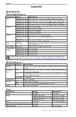


Index
GPSMAP
®
6000/7000 Series Owner’s Manual
satellite imagery
tide stations
zoom detail
front-of-boat offset
front panel
FTC
,
fuel capacity
fuel gauges
combinations screen
configuring
fuel economy
synchronizing with fuel
viewing
full-screen view
G
gain
large objects
radar type
sonar
Garmin Marine Network
gauges
fuel
limits
maximums
trip
Go To
GPS
performance
signals
graphs
air temperature
atmospheric pressure
configuring
water temperature
wind speed
Guide To
H
hazard colors
heading
heading line
,
home screen
I
IALA symbols
inset map
instrumentation data
K
keel offset
keys
power
,
range
L
land-based POIs
,
language
M
magnetic variation
,
Mariner’s Eye 3D
AIS
hazard colors
range rings
surface radar
marine services
MARPA
Sentry mode
tagged object
targeting
threats
N
,
navigation chart
aerial photos
chart borders
data bars
depth shading
light sectors
marine service points
MARPA
object information
panning
photo points
Radar Overlay
satellite imagery
vessel trails
zoom detail
navigation data bar
,
navigation lines
network connectors
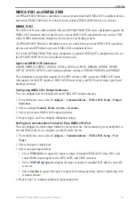
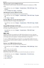
NMEA 0183
NMEA 2000
NOAA symbols
noise rejection
,
O
object information
off course alarm
offset
keel
water temperature
Offshore mode
other vessels
MARPA
projected heading
,
trails
,
P
panning
PC data
Perspective 3D
data bars


