background image

If a proximity alarm circle overlaps with an
existing alarm circle, a ‘proximity overlap’
warning will be displayed. As long as the over-
lap exists, the overlap warning will be dis-
played each time the GPSMAP is turned on.

If you enter an alarm circle overlap, the
GPSMAP will only inform you of the closest
proximity waypoint.

56

The next submenu listing on the Auxiliary Menu is the proximity 

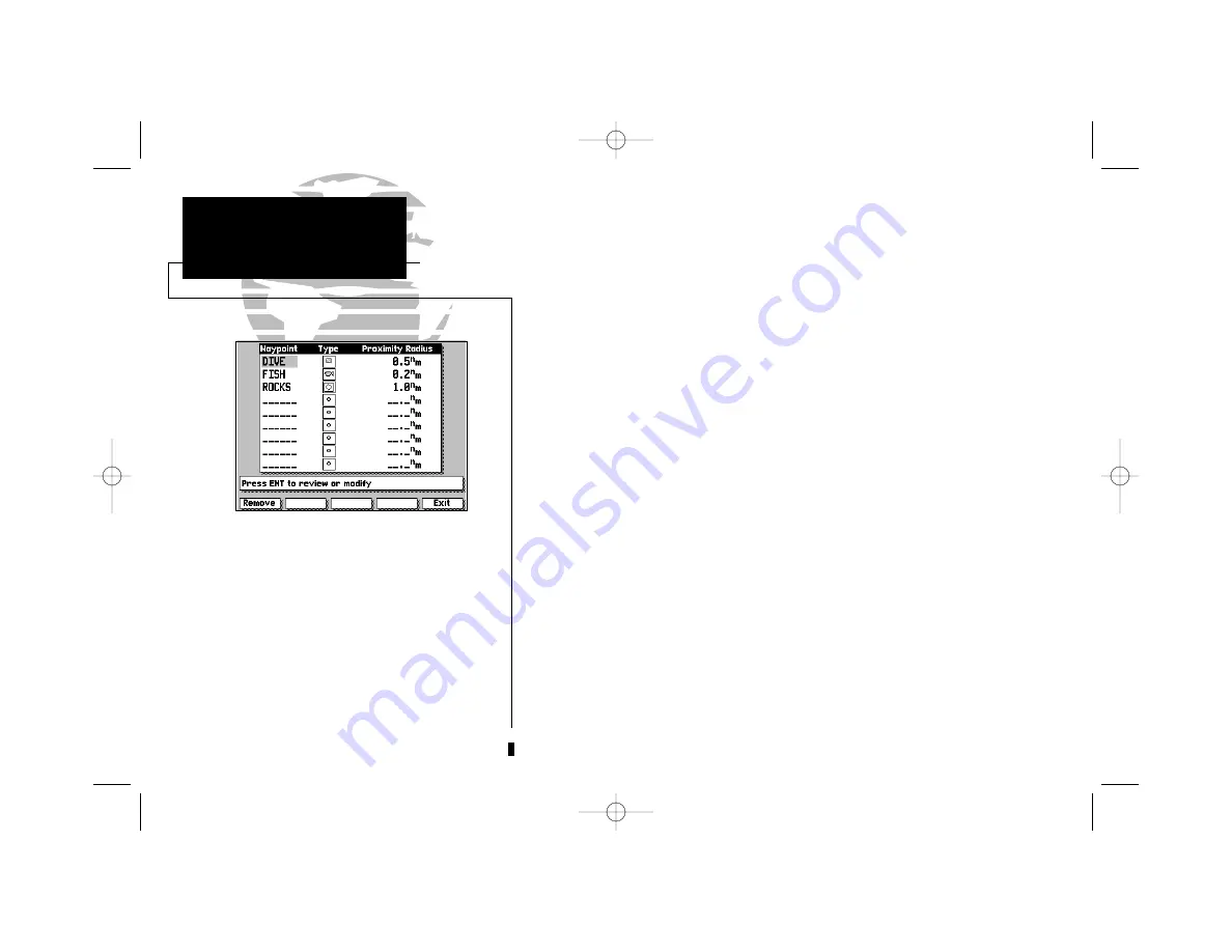
waypoints list. The proximity waypoints list lets you define an alarm circle
around a stored waypoint position, and can be used to help you avoid reefs,
rocks or restricted waters. Up to nine waypoints may be listed, with a 
maximum alarm radius of 99.9 nautical or statute miles or kilometers. The
alarm is turned on and off through the alarm/timer setup submenu.

To enter a proximity waypoint:

1. Highlight a blank proximity waypoint name field on the list and press 

C

.

2. Press the 

C

key to begin manually entering the waypoint name, 

or

3. Press the SCAN softkey to scan through all waypoints in memory.

4. Use the 

K

keypad to select the desired waypoint and press 

C

.

5. Press the OK softkey (twice if entering waypoint name manually). The radius

field will now be highlighted.

6. Press 

C

to begin entry of the proximity radius.

7. Use the 

K

keypad to enter a distance value and press 

C

.

To review a proximity waypoint from the list:

1. Use the 

K

key to highlight the waypoint to be reviewed.

2. Press the 

C

key.

3. Press the 

C

key again to return to the proximity list.

To remove a proximity waypoint from the list:

1. Use the 

K

key to highlight the waypoint to be removed.

2. Press the REMOVE softkey.

SECTION

9

AUXILIARY MENU

Proximity 

Waypoints List

215225manb.qxd  4/27/00  9:22 AM  Page 56

Summary of Contents for GPSMAP 215

Page 1: ...GPSMAP TM 215 225 OWNER S MANUAL REFERENCE 215225manb qxd 4 27 00 9 22 AM Page 1...

Page 2: ...215225manb qxd 4 27 00 9 22 AM Page 2...

Page 3: ...GARMIN Corporation hereby grants permission to download a single copy of this manual and of any revision to this manual onto a hard drive or other electronic storage medium to be viewed and to print o...

Page 4: ...ys the user is responsible for their prudent use CAUTION The GPSMAP does not contain any user serviceable parts Repairs should only be made by an authorized GARMIN service center Unauthorized repairs...

Page 5: ...be securely packaged with the tracking number clearly marked on the outside of the package and sent freight prepaid and insured to a GARMIN warranty service station A copy of the original sales receip...

Page 6: ...to read through this owner s manual and learn the operating procedures for your unit This manual covers the following GPSMAP units GPSMAP 215 3 gray level LCD chart plotter with built in GPS availabl...

Page 7: ...ge 15 16 Satellite and receiver status entering initial positions Section 2 Map Page Map Configuration 17 24 Using the target cursor selecting zoom scales calculating range and bearing map configurati...

Page 8: ...nu Options 46 61 System navigation and auxiliary functions and setups using the AUX softkey Section 10 Using G chartTM cartridges 62 64 Inserting removing and using electronic chart cartridges viewing...

Page 9: ...meter accuracy Fully gasketed high impact plastic alloy case Advanced Navigating and Plotting Over 1900 alphanumeric waypoints with selectable icons and comments Built in worldwide database usable fro...

Page 10: ...ion prompts E The MAPS key returns the display to the map page and or displays the outlines of chart coverage in use I The PAGE key scrolls through the main screen pages in sequence B The DATA key tur...

Page 11: ...ote that our tour will use the GPSMAP s built in worldwide database and the simulator mode so you won t have to install a chart cartridge or acquire satellites for this exercise The tour assumes you h...

Page 12: ...esponds to the M key directly below it and provides access to various route waypoint and auxiliary functions To see how softkeys work let s put the GPSMAP in simulator mode 1 Press the AUX softkey to...

Page 13: ...Press the C key to accept each choice and move to the next character posi tion When you accept a value for the last character position you will automatically return to the Satellite Status Page If you...

Page 14: ...ypoints and routes let s take a brief look at its various features and displays The Map Page can be broken down into three main sections map display data window and softkey menu The map display shows...

Page 15: ...od VMG and estimated time enroute ETE Your velocity made good is the speed you are closing in on a destination along your desired track while the ETE represents the total time left to reach your desti...

Page 16: ...ay near Andros Island and Nassau the position you entered earlier 3 Press the bottom arrow of the K keypad to move the cursor down to the first lat lon grid South of your boat s position 4 Using the K...

Page 17: ...ove the field highlight to the Wpt field and press C 2 Enter the name DAY1 with the K keypad pressing C after each character 3 After you ve entered the last letter press the OK softkey to confirm the...

Page 18: ...e route Although you may create a route in the Route 0 position be aware that it will automatically become the active route upon completion If you want to save a route created in the Route 0 position...

Page 19: ...eld tells us we re getting nowhere fast so let s go to the Highway Page and enter a speed for our simulated trip 1 Press the I key to display the Highway Page The Highway Page provides you with a larg...

Page 20: ...d course displays press the B key Now enter a speed of 60 knots for our simulated trip 1 Press the SOG COG softkey to display the Simulator SOG COG window 2 Press the C key to begin data entry 3 Use t...

Page 21: ...g the K key 2 Review a highlighted waypoint by pressing the C key 3 Change the ETE field to display ETA by pressing the B key Let s go back to the Map Page to look at our progress 1 Press the E key As...

Page 22: ...es when you want to head right to a specific destination without creating a route Imagine that as you were navigating the current route you see a spot of interest off the starboard bow By marking a ne...

Page 23: ...ion of this manual to help you with advanced navigation and setup functions The reference section is organized by topic so you can quickly find instructions for performing specific functions including...

Page 24: ...NCE SECTION 1 SATELLITE STATUS PAGE 2 MAP PAGE 3 HIGHWAY PAGE 4 ACTIVE ROUTE PAGE 5 WAYPOINTS 6 MARK KEY 7 GOTO MOB 8 ROUTES 9 AUXILIARY MENU 10 G CHART CARTRIDGES 14 215225manb qxd 4 27 00 9 22 AM Pa...

Page 25: ...position or DGPS status The status information will give you an idea of what the receiver is doing at any given moment The sky view and signal strength bars give you an indication of what satellites...

Page 26: ...OP and other factors such as signal quality to calculate a horizontal position error in feet or meters At the top right of the screen your present position and the current date and time are displayed...

Page 27: ...r map areas determine the distance and bearing to a position and perform various route and waypoint functions The GPSMAP system has a built in worldwide database to 64 n m see Appendix F for built in...

Page 28: ...p the boat centered the boat icon will move toward the edge of the display If the boat icon attempts to go off the display the zoom level may need to be adjusted to keep cartography on screen Whenever...

Page 29: ...the distance and bearing from your present position will change as your boat moves The cursor may also be used to snap to on screen waypoints and navaids allowing you to review the selected position d...

Page 30: ...yed using the data with the best resolution When the selected zoom range exceeds the resolution of the chart in use by up to two settings OVERZOOM cartography will be displayed The display will not sh...

Page 31: ...cursor The speed and course fields located below the destination fields display your present speed and course over ground SOG and COG Directly below these fields are the arrival and status fields The...

Page 32: ...ow cursor to the desired reference position and press the C key To clear a reference point press the CLEAR softkey 3 Use the K keypad to move the arrow cursor to the desired finish position The bearin...

Page 33: ...indicated by a box outline around the selection grid The far left column denotes range scales 64 n m 120 km and greater A check mark in a grid box indicates that the chart fea ture listed will be disp...

Page 34: ...ted range from the point of correction You should also only perform a map calibration when your boat is not moving The maximum correction is 16 400 feet 5000m Note that all map calibration offsets wil...

Page 35: ...fields on the Highway Page are the position and date time fields The position field displays your present GPS position or a simulator mode position you have entered manually The date time field displa...

Page 36: ...the highway to return to course When navigating a route the highway display will show each route waypoint in sequence Nearby waypoints not in the route will also be dis played You can zoom in or out...

Page 37: ...point first followed by the remaining route waypoints in sequence From the Active Route Page you can 1 Scroll through the entire list of route waypoints using the K keypad 2 Review the waypoint data f...

Page 38: ...tion 3 Press the C key to capture the position The New Waypoint window will appear with a default three digit name and graphic icon The position coordinates are displayed in the center of the window w...

Page 39: ...your GPSMAP system To change the waypoint icon comment or position 1 Highlight the icon comment or position field and press C 2 Use the K keypad to enter the new icon comment or position and press th...

Page 40: ...the K keypad to snap to the on screen waypoint 2 Press the DELETE softkey 3 Press the C key to confirm the deletion warning The WAYPOINTS softkey also provides access to the GPSMAP system s way point...

Page 41: ...splayed you may change any data field rename or delete the waypoint by following the steps outlined on page 29 You can also delete an individual waypoint or the entire list of waypoints right from the...

Page 42: ...n 6 To enter the position coordinates of the new waypoint highlight the position field and press C Use the K keypad to enter the position and press C to confirm the entry 7 To accept the new waypoint...

Page 43: ...OK prompt The last softkey function under the waypoints softkey is the nearest way points function The NEAREST softkey will display a list of the nine nearest waypoints within 100 nautical miles of y...

Page 44: ...your changes using the K keypad move the field highlight back to the OK prompt and press C To mark the cursor position 1 Use the K keypad to move the cursor to the desired position 2 Press the F key t...

Page 45: ...existing waypoint or is an on screen navaid you ll need to mark the position as a waypoint 2 Press the C key to confirm the arrow pointer position as your destination 3 If you want to accept the new...

Page 46: ...d begin navigating to the MOB position 3 If you only want to mark the MOB position and do not want to make the MOB position the active destination waypoint use the K keypad to highlight the NO prompt...

Page 47: ...The GARMIN route system is a powerful and extremely flexible system that you ll want to master to get the most out of your GPSMAP system Each route in the GPSMAP system has its own route number Route...

Page 48: ...on and press the C key HINT Once the map display is in route creation mode you can use the arrow cursor to snap to existing on screen waypoints or navaids or create new waypoint positions Existing way...

Page 49: ...the next active to waypoint As you complete navigation of each route leg this information will be updated to reflect the next active to waypoint in the route When you reach the final destination wayp...

Page 50: ...waypoint before the first route waypoint add a new route waypoint after the last route waypoint or add a new waypoint anywhere in between The REMOVE softkey will let you delete any waypoint from the...

Page 51: ...y 5 Press the C key to complete the insertion 6 Press the EXIT softkey to return to the route modification mode To insert a new waypoint in an existing route leg 1 Use the K keypad to snap to and high...

Page 52: ...route comment field highlight ed The waypoint list shows the route waypoints in sequence with the way point name symbol and bearing and distance between waypoints indicated To enter a route comment 1...

Page 53: ...ge the name symbol position or comment by highlighting the appropriate field and entering new information You can also replace any route waypoint with an existing or entirely new waypoint To replace a...

Page 54: ...oint in the list 1 Use the K keypad to highlight the existing route waypoint position where you want the new waypoint to appear 2 Press the INSERT softkey 3 To insert a waypoint from the main waypoint...

Page 55: ...o the first route waypoint field where you may select each waypoint of the new route by scanning your existing waypoint list or entering new waypoints To add existing or new waypoints to a route 1 Hig...

Page 56: ...time anchor drag waypoint proximity and off course Interface Setup Input output interface settings beacon receiver frequency bit rate Proximity Waypoints List of any designated proximity waypoints al...

Page 57: ...n from the list 2 Press the C key to see a list of menu options 3 Use the K keypad to highlight your choice and press C The data entry window is used for settings that require entry of numerical or al...

Page 58: ...hat entering an offset will not automatically display local time The local time setting above under Date Time Selection must also be selected Tone Selection lets you select an audible tone to sound fo...

Page 59: ...s or fathoms The default setting is meters Heading lets you select what reference is used in calculating heading information You can select to reference automatic magnetic variation true north grid he...

Page 60: ...Datum provides a list of the available map datums for use with the GPSMAP system For a list of the available GPSMAP datums see Appendix F A user datum option is also available to allow entry of your o...

Page 61: ...the alarm on and off Arrival Alarm lets you specify an alarm to sound when you re a specified dis tance away from a destination waypoint Enter a distance radius for sounding the alarm and use the con...

Page 62: ...n an NMEA format The GPSMAP supports NMEA 0180 0182 0183 v 1 5 and 0183 v 2 0 options See Appendix B for additional NMEA sentence information NMEA In No Out supports waypoint input from external devic...

Page 63: ...s format is suitable for non GARMIN automatic or manually tuned receivers which provide RTCM correction data To specify an I O format highlight the I O format field press C and select an option from t...

Page 64: ...accuracy and maintenance For DGPS transmitter problems or to find the most updated list of frequencies coverage areas contact your local USCG or see their web site at http www navcen uscg mil To have...

Page 65: ...rinter Out can output course information to a serial printer To enable the serial printer output 1 Activate the Interface Setup Menu 2 Using the K key highlight the I O Format field and press C 3 Usin...

Page 66: ...m timer setup submenu To enter a proximity waypoint 1 Highlight a blank proximity waypoint name field on the list and press C 2 Press the C key to begin manually entering the waypoint name or 3 Press...

Page 67: ...with a list of the remaining route waypoints in sequence below The distance fuel required and ETE displayed are the total values from the starting waypoint to each listed waypoint with the desired tra...

Page 68: ...Enter a speed and hourly fuel flow in the appropriate fields 4 Enter the departure date and time for your trip Once you ve entered your speed fuel and date time values the trip information will be ca...

Page 69: ...last defined ground track before recording a new track point Interval Value defines the distance or time interval used to record the track plot Erase Track Memory lets you clear all track plot data c...

Page 70: ...d leave the GPSMAP on to automatically record track log positions while underway see page 59 2 Select the Start TracBack option from the track recording submenu and press C to create activate the Trac...

Page 71: ...tions window is also used to access any current messages in your unit There are two types of messages used in the GPSMAP system temporary messages eg approaching a waypoint and condition messages eg n...

Page 72: ...installed and accepted 5 Close the cover and turn the latch ring 1 4 turn clockwise to secure The car tridge door features a sealing gasket to keep moisture out of the G chart area If you insert a G...

Page 73: ...ange scales Whenever you zoom past the usable range of the current electronic chart the range field will display Ovr Zm or No Map These warnings indicate that although you may still have cartography y...

Page 74: ...formation icon Once the icon is selected an information box appears at lower right corner of the screen showing the name of the selected port 2 Press C to display the full listing of available service...

Page 75: ...more information on these items GA23 H Field antenna Flush Mount Kit 30 Antenna Cable Extension 110 220 volt AC adapter Cigarette Lighter Adapter Reading through the entire installation section before...

Page 76: ...vessel earth ground Do not ground the coupler to the electrical system GARMIN antennas screw directly onto any standard 1 x 14 thread antenna mount If you need to raise an antenna to avoid shading tr...

Page 77: ...on the supplied power data cable See the beacon receiver owner s manual for connection information not covered in the above diagram 67 SECTION A APPENDIX Installation A second 1 x 14 thread antenna mo...

Page 78: ...TFT screens the GPSMAP 225 performs best in shaded conditions protect ed from direct sunlight To install the GPSMAP unit 1 Place the mounting bracket in the desired location 2 Mark and drill the four...

Page 79: ...xternal alarm device and to a PC see PC connection info above To connect to an NMEA device use the BLUE out and BLACK ground harness leads Some devices will support bi directional data exchange For th...

Page 80: ...WPL Proprietary sentences PGRMM map datum PGRMZ altitude PSLIB beacon receiver control input NMEA 0183 version 2 0 Approved sentences GPGGA GPGSA GPGSV GPRMB GPRMC GPRTE GPWPL Proprietary sentences PG...

Page 81: ...n Accuracy 1 5 meters 3 15 ft with DGPS corrections 15 meters 49 ft RMS Velocity Accuracy 0 1 knot RMS steady state Dynamics 6g s POWER Input 10 40vDC Usage 15 watts max 9 watts typical 215 25 watts m...

Page 82: ...s than one minute away from reaching a destination way point at your present speed over ground Arrival At You are within the distance specified on the timer alarm setup from reaching your final destin...

Page 83: ...he GPSMAP cannot acquire the necessary number of satellites to compute a position Power Down and Re init The GPSMAP cannot calculate a position due to abnormal satellite conditions Power down and veri...

Page 84: ...is in AutoLocateTM mode Stored Data Lost All waypoints routes and almanac data has been lost due to internal battery failure Timer Expired The countdown timer has expired Track Memory Full The track...

Page 85: ...022 5 1 E022 5 to E037 5 2 E037 5 to E052 5 3 E052 5 to E067 5 4 E067 5 to E082 5 5 E082 5 to E097 5 6 E097 5 to E112 5 7 E112 5 to E127 5 8 E127 5 to E142 5 9 E142 5 to E157 5 10 E157 5 to E172 5 11...

Page 86: ...d 66 Australian Geod 66 Australia Tasmania Island Austria Austria Astrln Geod 84 Australian Geod 84 Australia Tasmania Island Bellevue IGN Efate and Erromango Islands Bermuda 1957 Bermuda 1957 Bermuda...

Page 87: ...n Bngldsh Indian Bangladesh India Nepal Indian Thailand Indian Thailand Vietnam Indonesia 74 Indonesia 1974 Indonesia Ireland 1965 Ireland 1965 Ireland ISTS 073 Astro ISTS 073 ASTRO 69 Diego Garcia Jo...

Page 88: ...ile Colombia Ecuador Guyana Peru Venezuela Prov S Chln 63 So Chilean 63 S Chile Puerto Rico Puerto Rico Virgin Isl Qatar National Qatar National Qatar Qornoq Qornoq South Greenland Reunion Reunion Mas...

Page 89: ...radio beacons to transmit position corrections to GPS receivers Estimated Time of Arrival ETA The time of day of your arrival at a destination Estimated Time Enroute ETE The time left to your destina...

Page 90: ...0 longitude in Greenwich England Universal Transverse Mercator UTM A grid coordinate system that projects global sections onto a flat surface to measure position in specific zones Velocity Made Good V...

Page 91: ...te fishing spots and other waypoints recorded as TDs You can display your position as a TD or enter waypoints as TDs The accuracy to be expected from this conversion is approxi mately thirty meters Wh...

Page 92: ...s 1 Press the M under SETUP TD 2 Use the K key to select the field to change and press C 3 Use the K key to highlight the new setting and press C 4 When done press the M key under the word EXIT to exi...

Page 93: ...Countdown Elapsed Timers 51 Creating Routes 38 45 Creating Waypoints 28 32 Cross Track Error 79 CTR Key viii 6 19 Cursor Mode 18 Cursor Movement 6 19 D Data Entry 3 47 DATA Key viii 4 10 11 22 25 Data...

Page 94: ...tion 23 24 Map Datum List 76 78 Map Datum Selection 50 Map Display 4 Map Orientation 50 Map Page 17 24 Map Scales 20 MAPS Key viii 11 63 Marine Data 23 MARK Key viii 7 34 Marking Positions 7 34 MENU K...

Page 95: ...s 8 37 45 Route Comments 42 Route Planning Mode 57 S Satellite Acquisition 15 16 Signal Strength Bars 15 Simulator Mode 2 48 Simulator Tour 1 13 Sky View Satellite 15 Softkeys 2 Softkey Menu 5 22 Sate...

Page 96: ...215225manb qxd 4 27 00 9 22 AM Page 86...

Page 97: ...215225manb qxd 4 27 00 9 22 AM Page 87...

Page 98: ...66062 U S A Web Site Address www garmin com GARMIN Europe Ltd Unit 5 The Quadrangle Abbey Park Romsey Hampshire SO51 9AQ U K Garmin Asia Corp No 68 Jangshu 2nd Rd Shijr Taipei County Taiwan Part Numbe...

Reviews: