91
WAAS
Appendix B
When should you use WAAS?
Utilizing the WAAS feature will improve the horizontal position and altitude accuracy of your
GPSMAP 295. Consider using this feature when you need the benefits of improved accuracy, but keep
the following limitations in mind:
• WAAS satellites are located at low elevation angles in the southern sky. If you are flying a
northbound heading and using an antenna located inside the cockpit, it is doubtful that the GPSMAP
295 will be able to see a WAAS satellite. Similarly, when using the GPSMAP 295 in your car, the
buildings and trees that you pass will likely block WAAS satellites from view.
• Decoding the differential data provided by WAAS satellites involves considerable microprocessor
activity. You may notice a decrease in overall performance when the WAAS feature is enabled, as
indicated by slower response times and a slower map screen redraw rate. If you experience significant
operational delays, disable the WAAS feature.
• WAAS is currently available in the United States and adjacent areas of Canada and Mexico. If you
are using the GPSMAP 295 in other parts of the world, disable the WAAS feature to increase unit
response times. WAAS will be available in Europe and other parts of the world in the future.
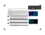
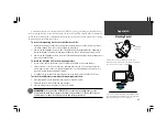
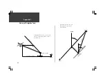
Throughout the United States, WAAS satellites (#35 in this
example) will appear at low elevation angles in the southern
sky. Objects such as buildings, trees, or the aircraft itself can
interfere with reception of WAAS satellites. For aircraft use,
optimum WAAS reception is acheived by installing an
outside antenna.
Summary of Contents for GPSMAP 295
Page 1: ...Introduction 1 GPSMAP 295 Pilot s Guide Reference...
Page 2: ...2 Introduction...
Page 114: ...104 Appendix G...
Page 115: ...Appendix G 105...

