


GPSMAP 4000/5000/6000/7000 Series Weather and XM Satellite Radio Supplement
9
XM WX Satellite Weather and Cellular Weather
5. Complete an action:
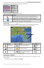
• To view present weather conditions from a local weather service, select
Current Cond.
• To view a local weather forecast, select
Forecast
.
• To view surface wind and barometric pressure information, select
Sea Surface
.
• To view wind and wave information, select
Marine Bulletin
.
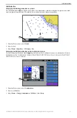
Creating a Waypoint on the Forecast Chart
1. From the Home screen, select
Weather
.
2. Select a weather chart.
3. Complete an action:
• Select a location on the chart.
• Drag the screen to pan to a new location, and select the location on the chart.
4. Select
Create Waypoint
.
5. If you want to name the waypoint or provide information about the waypoint, select the waypoint on the right
side of the screen, and select
edit
.
• Select
Name
, enter the name, and select
Done
.
• Select
Symbol
, and enter a symbol.
• Select
Depth
, enter the depth, and select
Done
.
• Select
Water temp
, enter the water temperature, and select
Done
.
• Select
Comment
, enter the comment, and select
Done
.
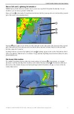
About the Weather Overlay
The weather overlay superimposes weather and weather-related information on the Navigation chart, the Fishing
chart, and the Perspective 3D chart view. The Navigation chart and the Fishing chart can show WX radar, height
of cloud tops (XM weather), infrared satellite data for clouds (cellular weather), lightning, WX buoys, county
warnings, and hurricane warnings. The Perspective 3D chart view can show WX radar.
Weather overlay settings configured for use on one chart are not applied to another chart. The weather overlay
settings for each chart must be configured separately.
Note
: The Fishing chart is available if you use a BlueChart
®
g2 Vision
®
data card, a BlueChart g2 data card, or if
your built-in map supports Fishing charts.
Turning On the Weather Overlay on a Chart
1. From the Home screen, select
Charts
.
2. Select
Navigation Chart
or
Fishing Chart
.
3. Select
Menu
>
Chart Setup
>
Weather
>
on
.
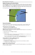
Showing WX Radar Precipitation Data on a Chart
Before you can show WX radar information on a chart, you must turn on the weather overlay
WX radar shows very light rain and snow up to strong thunderstorms in varying shades and colors.
1. From the Home screen, select
Charts
.
2. Select
Navigation Chart
or
Fishing Chart
.
3. Select
Menu
>
Chart Setup
>
Weather
>
WX RADAR
>
on
.
Showing Weather Buoys on a Chart
Before you can show weather buoys on a chart, you must turn on the weather overlay (
1. From the Home screen, select
Charts
.
2. Select
Navigation Chart
or
Fishing Chart
.
3. Select
Menu
>
Chart Setup
>
Weather
>
WX Buoys
>
on
.
Summary of Contents for GPSMAP 4000 Series
Page 1: ...GPSMAP 4000 5000 6000 7000 Series Weather and XM Satellite Radio supplement...
Page 21: ......
Page 22: ......
Page 23: ......